Morogues
Morogues | |
|---|---|
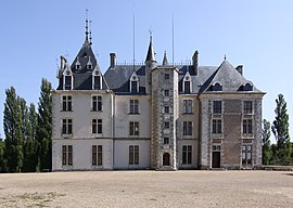 The Château of Maupas | |
show Location of Morogues | |
 Morogues | |
| Coordinates: 47°14′30″N 2°35′55″E / 47.2417°N 2.5986°ECoordinates: 47°14′30″N 2°35′55″E / 47.2417°N 2.5986°E | |
| Country | France |
| Region | Centre-Val de Loire |
| Department | Cher |
| Arrondissement | Bourges |
| Canton | Saint-Germain-du-Puy |
| Intercommunality | CC Terres du Haut Berry |
| Government | |
| • Mayor (2020–2026) | Gérard Clavier[1] |
| Area 1 | 30.53 km2 (11.79 sq mi) |
| Population (Jan. 2018)[2] | 437 |
| • Density | 14/km2 (37/sq mi) |
| Time zone | UTC+01:00 (CET) |
| • Summer (DST) | UTC+02:00 (CEST) |
| INSEE/Postal code | 18156 /18220 |
| Elevation | 200–427 m (656–1,401 ft) (avg. 210 m or 690 ft) |
| 1 French Land Register data, which excludes lakes, ponds, glaciers > 1 km2 (0.386 sq mi or 247 acres) and river estuaries. | |


Morogues (French pronunciation: [mɔʁɔɡ]) is a commune in the Cher department in the Centre-Val de Loire region of France.
Geography[]
An area of forestry, vineyards and farming, comprising the village and a couple of hamlets situated some 15 miles (24 km) northeast of Bourges, at the junction of the D185 with the D59 and D212 roads.
Population[]
| Year | Pop. | ±% |
|---|---|---|
| 1962 | 422 | — |
| 1968 | 492 | +16.6% |
| 1975 | 397 | −19.3% |
| 1982 | 376 | −5.3% |
| 1990 | 456 | +21.3% |
| 1999 | 424 | −7.0% |
| 2008 | 465 | +9.7% |
Sights[]
- The church of St. Symphorien, dating from the twelfth century.
- The fifteenth-century chateau of Maupas.
- A watermill, the “Moulin Quenouille”.
See also[]
- Communes of the Cher department
References[]
- ^ "Répertoire national des élus: les maires". data.gouv.fr, Plateforme ouverte des données publiques françaises (in French). 2 December 2020.
- ^ "Populations légales 2018". INSEE. 28 December 2020.
External links[]
| Wikimedia Commons has media related to Morogues. |
- Official website of Morogues (in French)
| show Communes of the Cher department |
|---|
Categories:
- Communes of Cher (department)