Corquoy
Corquoy | |
|---|---|
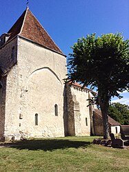 The church of Saint-Martin, in Corquoy | |
show Location of Corquoy | |
 Corquoy | |
| Coordinates: 46°53′54″N 2°17′34″E / 46.8983°N 2.2928°ECoordinates: 46°53′54″N 2°17′34″E / 46.8983°N 2.2928°E | |
| Country | France |
| Region | Centre-Val de Loire |
| Department | Cher |
| Arrondissement | Saint-Amand-Montrond |
| Canton | Trouy |
| Intercommunality | CC Arnon Boischaut Cher |
| Government | |
| • Mayor (2020–2026) | Dominique Burlaud |
| Area 1 | 36.57 km2 (14.12 sq mi) |
| Population (Jan. 2018)[1] | 206 |
| • Density | 5.6/km2 (15/sq mi) |
| Time zone | UTC+01:00 (CET) |
| • Summer (DST) | UTC+02:00 (CEST) |
| INSEE/Postal code | 18073 /18190 |
| Elevation | 128–179 m (420–587 ft) |
| 1 French Land Register data, which excludes lakes, ponds, glaciers > 1 km2 (0.386 sq mi or 247 acres) and river estuaries. | |


Corquoy (French pronunciation: [kɔʁkwa]) is a commune in the Cher department in the Centre-Val de Loire region of France. On 1 January 2019, the former commune Sainte-Lunaise was merged into Corquoy.[2]
Geography[]
An area of farming and forestry comprising a village and two hamlets situated in the Cher River valley some 15 miles (24 km) south of Bourges on the D35 and the D27 roads.
Population[]
| Year | Pop. | ±% |
|---|---|---|
| 1962 | 228 | — |
| 1968 | 250 | +9.6% |
| 1975 | 222 | −11.2% |
| 1982 | 216 | −2.7% |
| 1990 | 236 | +9.3% |
| 1999 | 207 | −12.3% |
| 2008 | 238 | +15.0% |
Sights[]
- The twelfth-century church of St. Martin.
- The thirteenth-century chapel of the old priory of Grandmont.
See also[]
- Communes of the Cher department
References[]
- ^ "Populations légales 2018". INSEE. 28 December 2020.
- ^ Arrêté préfectoral 27 September 2018 (in French), p. 260
| Wikimedia Commons has media related to Corquoy. |
| show Communes of the Cher department |
|---|
Categories:
- Communes of Cher (department)