Clémont
Clémont | |
|---|---|
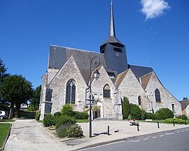 The church in Clémont | |
 Coat of arms | |
show Location of Clémont | |
 Clémont | |
| Coordinates: 47°34′08″N 2°18′29″E / 47.5689°N 2.3081°ECoordinates: 47°34′08″N 2°18′29″E / 47.5689°N 2.3081°E | |
| Country | France |
| Region | Centre-Val de Loire |
| Department | Cher |
| Arrondissement | Vierzon |
| Canton | Aubigny-sur-Nère |
| Intercommunality | Sauldre et Sologne |
| Government | |
| • Mayor (2008–2014) | Thierry de Montbel |
| Area 1 | 50.11 km2 (19.35 sq mi) |
| Population (Jan. 2018)[1] | 715 |
| • Density | 14/km2 (37/sq mi) |
| Time zone | UTC+01:00 (CET) |
| • Summer (DST) | UTC+02:00 (CEST) |
| INSEE/Postal code | 18067 /18410 |
| Elevation | 134–168 m (440–551 ft) (avg. 130 m or 430 ft) |
| 1 French Land Register data, which excludes lakes, ponds, glaciers > 1 km2 (0.386 sq mi or 247 acres) and river estuaries. | |


Clémont is a commune in the Cher department in the Centre-Val de Loire region of France.
Geography[]
A village of lakes, forestry and farming situated in the valley of the river Sauldre, some 35 miles (56 km) north of Bourges at the junction of the D7, D79 and the D923 roads. The commune borders the department of Loiret.
Population[]
| Year | Pop. | ±% |
|---|---|---|
| 1962 | 670 | — |
| 1968 | 670 | +0.0% |
| 1975 | 655 | −2.2% |
| 1982 | 600 | −8.4% |
| 1990 | 631 | +5.2% |
| 1999 | 642 | +1.7% |
| 2008 | 683 | +6.4% |
Sights[]
- The church of St. Etienne, dating from the nineteenth century.
- The chateau of Lauroy, dating from the seventeenth century.
See also[]
- Communes of the Cher department
References[]
- ^ "Populations légales 2018". INSEE. 28 December 2020.
| Wikimedia Commons has media related to Clémont. |
| show Communes of the Cher department |
|---|
Categories:
- Communes of Cher (department)