Veaugues
Veaugues | |
|---|---|
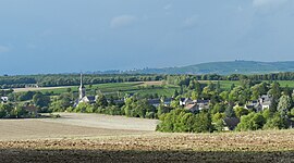 A general view of Veaugues | |
show Location of Veaugues | |
 Veaugues | |
| Coordinates: 47°15′29″N 2°45′31″E / 47.2581°N 2.7586°ECoordinates: 47°15′29″N 2°45′31″E / 47.2581°N 2.7586°E | |
| Country | France |
| Region | Centre-Val de Loire |
| Department | Cher |
| Arrondissement | Bourges |
| Canton | Sancerre |
| Intercommunality | CC Pays Fort Sancerrois Val de Loire |
| Government | |
| • Mayor (2020–2026) | Jean-Yves Pelé |
| Area 1 | 27.92 km2 (10.78 sq mi) |
| Population (Jan. 2018)[1] | 633 |
| • Density | 23/km2 (59/sq mi) |
| Time zone | UTC+01:00 (CET) |
| • Summer (DST) | UTC+02:00 (CEST) |
| INSEE/Postal code | 18272 /18300 |
| Elevation | 180–346 m (591–1,135 ft) |
| 1 French Land Register data, which excludes lakes, ponds, glaciers > 1 km2 (0.386 sq mi or 247 acres) and river estuaries. | |


Veaugues (French pronunciation: [voɡ]) is a commune in the Cher department in the Centre-Val de Loire region of France.
Geography[]
An area of winegrowing, forestry and farming comprising the village and a couple of hamlets situated on the banks of the small Planche-Goddard river, about 24 miles (39 km) northeast of Bourges at the junction of the D86 with the D49, D59 and D955 roads. The commune is one of 14 that grow grapes for the production of Sancerre AOC wine.
Population[]
| Year | Pop. | ±% |
|---|---|---|
| 1962 | 541 | — |
| 1968 | 610 | +12.8% |
| 1975 | 631 | +3.4% |
| 1982 | 603 | −4.4% |
| 1990 | 564 | −6.5% |
| 1999 | 610 | +8.2% |
| 2008 | 653 | +7.0% |
Sights[]
- The church of St. Aignan, dating from the twelfth century.
- The feudal motte.
- A watermill.
See also[]
- Communes of the Cher department
References[]
- ^ "Populations légales 2018". INSEE. 28 December 2020.
| Wikimedia Commons has media related to Veaugues. |
| show Communes of the Cher department |
|---|
Categories:
- Communes of Cher (department)