Eğil
Eğil | |
|---|---|
 | |
 Eğil | |
| Coordinates: 38°15′26″N 40°05′05″E / 38.25722°N 40.08472°ECoordinates: 38°15′26″N 40°05′05″E / 38.25722°N 40.08472°E | |
| Country | Turkey |
| Province | Diyarbakır |
| Government | |
| • Government Appointed Acting Mayor | İdris Arslan |
| • Kaymakam | İdris Arslan |
| Area | |
| • District | 498.91 km2 (192.63 sq mi) |
| Population (2012)[2] | |
| • Urban | 5,069 |
| • District | 23,028 |
| • District density | 46/km2 (120/sq mi) |
| Post code | 21470 |

Eğil (Ottoman Turkish: اکيل,[3] Kurdish: Egil)[4] is a town and district of Diyarbakır Province of Turkey. As of 2018, the district's population is 23,369.[5] The elected mayor Mustafa Akkul of the Peoples' Democratic Party (HDP) was dismissed on the 23 March 2020 and replaced by a trustee.[6] The current Kaymakam is İdris Arslan.[7]
Eğil is an ancient city 50 km away from Diyarbakır with many ancient forts and caves dating to the time of the Armenian kingdom of Sophene. It is identified with Carcathiocerta, the capital of the Kingdom of Sophene, and the ancient Armenian religious center of Angegh-tun (Angełtun).[8] It is known as the "City of Prophets." It has been ruled by the Armenians, the Assyrians, the Romans, the Byzantines, the Abbasids, the Seljuks and the Ottoman Empire.
In 2018 parts of a village re-emerged in Eğil in the Çakırören neighbourhood, after the Dicle Dam suffered water level decrease due to a burst of one of the gates.[9] It is also the location of a supposed tomb of Elisha, which is located in the Kale neighborhood of Eğil.[10]
History[]
Most scholars identify Eğil with the ancient city of Carcathiocerta.[11] The city, with its strategic location overlooking the west bank of the Tigris, is the oldest in the region,[dubious ] with remains dating back to the Assyrian and Hellenistic periods. Later on, the city was known in Armenian as Angł, capital of the district of Angełtun, which was known as Ingilene in Greco-Roman sources. It was part of the larger province of Sophene. Armenian sources described Angł as housing "the tombs of the former kings of Armenia", apparently taking the rulers of Sophene as a branch of the Armenian kings' dynasty. The rock-cut tombs still exist today at Eğil.[11]
Gallery[]
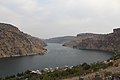
Eğil Dam Reservoir
Eğil Dam Reservoir

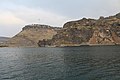
Eğil King Tombs

Eğil King Tombs
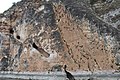
Eğil King Tombs
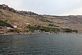
Eğil


References[]
- ^ "Area of regions (including lakes), km²". Regional Statistics Database. Turkish Statistical Institute. 2002. Retrieved 2013-03-05.
- ^ "Population of province/district centers and towns/villages by districts - 2012". Address Based Population Registration System (ABPRS) Database. Turkish Statistical Institute. Retrieved 2013-02-27.
- ^ Tahir Sezen, Osmanlı Yer Adları (Alfabetik Sırayla), T.C. Başbakanlık Devlet Arşivleri Genel Müdürlüğü, Yayın Nu 21, Ankara, p. 163.
- ^ Kürtçe Anamnez - Anamneza bi Kurmancî (PDF) (in Kurdish and Turkish). 2009. p. 55. Retrieved 18 December 2019.
- ^ "Eğil Nüfusu Diyarbakır". www.nufusu.com. Retrieved 2020-01-22.
- ^ "HDP's Eğil Co-Mayor Arrested".
{{cite web}}: CS1 maint: url-status (link) - ^ "Kaymakam İdris Arslan". www.egil.gov.tr. Retrieved 2020-03-25.
{{cite web}}: CS1 maint: url-status (link) - ^ Marciak, Michał (2017). Sophene, Gordyene, and Adiabene: Three Regna Minora of Northern Mesopotamia Between East and West. Brill. pp. 43–44. ISBN 9789004350724.
- ^ AA, Daily Sabah with (2018-12-20). "Drop in dam water reveals submerged village, Elisha's tomb in SE Turkey's Diyarbakır". Daily Sabah. Retrieved 2020-03-25.
- ^ "Ancient Underwater Village Has Been Revealed in Turkey (photos)". armedia.am. Retrieved 2020-03-25.
- ^ a b Marciak, Michał (2014). "The Historical Geography of Sophene". Acta Antiqua. 52 (4): 295–338. doi:10.1556/aant.52.2012.4.1.

- Kurdish settlements in Turkey
- Populated places in Diyarbakır Province
- Districts of Diyarbakır Province