Joué-sur-Erdre
Joué-sur-Erdre
Yaoued | |
|---|---|
Commune | |
 | |
 Coat of arms | |
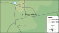
show Location of Joué-sur-Erdre | |
 Joué-sur-Erdre | |
| Coordinates: 47°29′47″N 1°25′08″W / 47.4964°N 1.4189°WCoordinates: 47°29′47″N 1°25′08″W / 47.4964°N 1.4189°W | |
| Country | France |
| Region | Pays de la Loire |
| Department | Loire-Atlantique |
| Arrondissement | Châteaubriant-Ancenis |
| Canton | Nort-sur-Erdre |
| Intercommunality | Pays d'Ancenis |
| Government | |
| • Mayor (2020–2026) | Jean-Pierre Belleil |
| Area 1 | 54.53 km2 (21.05 sq mi) |
| Population (Jan. 2018)[1] | 2,516 |
| • Density | 46/km2 (120/sq mi) |
| Time zone | UTC+01:00 (CET) |
| • Summer (DST) | UTC+02:00 (CEST) |
| INSEE/Postal code | 44077 /44440 |
| Elevation | 7–66 m (23–217 ft) (avg. 37 m or 121 ft) |
| 1 French Land Register data, which excludes lakes, ponds, glaciers > 1 km2 (0.386 sq mi or 247 acres) and river estuaries. | |


Joué-sur-Erdre is a commune in the Loire-Atlantique department in western France.
Etymology[]
Joué is first mentioned as Joseio in 1186.[2][3]
It belongs to the long list of Gallo-Romance toponyms such as Joué, Jouy, Gouy and Occitano-Catalan Gaujac having as origin Gaudiacu cf. Joué-en-Charnie (Sarthe, Gaudiaco 1186) or Joué-Étiau (Maine-et-Loire, Gaudiacus AB 7th, etc.[2] It is a compound of Gaudi(us), a Christian name based on gaudius "joy" and the Gaulish (Celtic) suffix -acum "place, property" cf. Welsh -og.[2]
Its Breton name is Yaoued. The Breton name of the people from Yaoued is Yaouedad (for men) and Yaouedadez (for women).
Sur-Erdre ("Upon-the-Erdre") was added in the 19th century and it refers to the river name Erdre, itself from a Celtic *ered "running stream". The river is mentioned as Erda in the 11th century[4]
Geography[]
Situation[]
Joué-sur-Erdre is at 47°29′47″N 1°25′08″W / 47.49639°N 1.41889°W, in western France in Loire-Atlantique. The commune is 29 km north-west of Ancenis and 30 km north-east of Nantes.
The commune is, as the crow flies, 318 km of Paris.

Relief[]
The highest point in the city is 66 meters above the sea level, the deepest one is seven meters above. The mean elevation is 37 meters above the sea level.
Hydrology[]
The commune is crossed by the Erdre and the Isac rivers.
The was extended in 1835 to reach 200 ha.
Climate[]
Global warming[]
Although the highest point of the commune is 66 meters above the sea level, the mean level is 37 meters. That is to say that the commune is concerned by the global warming and the elevation of the sea level.
Joué-sur-Erdre is among the 69,68% communes concerned by this elevation.[5][6]
Town planning[]
Urban morphology[]
The commune is made up of the principal village and many other hamlets as , , , , , and .

Map of Joué-sur-Erdre.

Map of la Demenure.

Map of la Mulonnière.
Map of la Gicquelière.


Communications and transports[]
The , running from east/west, crosses Joué-sur-Erdre.
The hamlet of Gros Breil is crossed by the railroad.
The nearest airport is in Ancenis.
Adjacent villages[]
| Northwest: Abbaretz | North: La Meilleraye-de-Bretagne | Northeast: Riaillé |
| West: Saffré | Joué-sur-Erdre | East: Trans-sur-Erdre |
| Southwest: Nort-sur-Erdre | South: Les Touches | Southeast: Trans-sur-Erdre |
History[]
In the 9th century, to shield the country from Norman invasion waves, a fort called Alon was built on what is now known as Joué-sur-Erdre.[7]
At the beginning of the 13th century, the castle of Vioreau and its neighbouring lands were called "Joué" referring to the lord who lived in, Hervé de Joué. In this time, Joué was the heart of the greatest seigniory near Nantes with a surface reaching twenty parishes in the 16th century. It was later assimilated in the Barony of Chateaubriant.[7]
Two castles still exist in the parish, Lucinière and la Chauvelière. In the first one used to live the bishops of Nantes from the 15th to the 16th centuries. The castle of la Chauvelière used to belong to the Brittany chancellor.[7]
On 13 August 1487, after the failure of the siege of Nantes (from 19 June to 6 August 1487) hold by the duc de Bretagne, King Charles VIII and Anne of Beaujeu encamped with their troops in Joué.[7]
In 1592, during the Holy League, Joué-sur-Erdre and Nort-sur-Erdre hosted 12,000 French and Spanish troops headed by the Duke of Mercœur.[7]
On 30 May 1847, the village took its current name of Joué-sur-Erdre.[7]
Economy[]
Employment[]
In 2017, the labor force reached 1,162 people. The unemployment rate of the village was 10.9%.[8]
| Farmers | Craftsmen, storekeepers, business managers | Cadre, Intellectual | Professions intermédiaires ('Intermediate occupations') |
Employee | Blue-collar worker | |
|---|---|---|---|---|---|---|
| Joué-sur-Erdre[8] | 2.7% | 4.9% | 11.4% | 25.5% | 28.1% | 26.7% |
| National average[9] | 1.6% | 6.7% | 18.2% | 26.0% | 27.6% | 19.9% |
Politics and administration[]
Political tendencies and results[]
French European Constitution referendum of 2005[]
During the European Constitution referendum which took place on 29 May 2005, there were 40,39% voting "yes" and 59,61% voting "no". The abstention rate was 26,04%.[10]
French presidential election of 2007[]
During the first round Nicolas Sarkozy obtained 27,74% of the votes and Ségolène Royal obtained 25,12%. During the second round 53,06% of the votes were obtained by des voix furent remportées par Nicolas Sarkozy against 46,94% for Ségolène Royal. The participation rate was 86,48% (nationwide : 83,97%) and spoilt vote represented 3,75% of the electors (nationwide : 4,20%).
French legislative election of 2007[]
Joué-sur-Erdre is part of the Loire-Atlantique's 5th constituency.
During the second round Michel Ménard was elected.
| Candidate | Party | % | Votes |
|---|---|---|---|
| Michel Ménard | PS | 51,11 % | 36,891 |
| UMP | 48,89 % | 35,292 |
French municipal elections of 2008[]
Joué-sur-Erdre's population is between 1500 and 2500 inhabitants, thus they elect 19 counsellors.
The new mayor is Jean-Pierre Belleil.
List of mayors[]
| Term | Name | Political Party | Notes |
|---|---|---|---|
| 1800 - 1809 | Eugène François Roussel | ||
| 1810–1814 | François Lecudon | Notary. | |
| 1815 - December 13, 1820 | Aimé-Désiré Anneau | Notary. Dead on December 13, 1820, he was 38. | |
| 1821 - January 1833 | François Priou | Geometrician | |
| February 1833 - August 1840 | Jacques-Désiré Marbin | ||
| August 1840 - June - 1844 | Pierre Guillaume Louis Calice | Châtelain de l'Auvinière | |
| November 1844 - September 1870 | Marc Jacques Pierre Nouais | ||
| May 1871 - 1878 | Jean-Baptiste Nouais | ||
| March 1878 - ? | Amaury de Goyon Matignon de Marcé | Marquis. Mayor during 1881, 1886 and 1891 censuses. | |
| ? | Mr Nouais | Mayor during 1896 and 1901 censuses. | |
| ? | Amaury de Goyon | ? | Marquis. Mayor during 1906 census and in 1918. |
| ? | ? | ? | ? |
| ? - March 2001 | Isabelle Le Gualès de Mézaubran | ||
| March 2001 - March 2008 | Hervé Lubert | DVD | |
| March 2008 - in office | Jean-Pierre Belleil | Farmer |
Environmental politics[]
The allée de Chênes ("alley of Oaks") of the , also called "la Grande Avenue", is a classified environmental site since February 9, 1949.[13][14] It shelters tercentenaries oaks.
Population[]
|
| |||||||||||||||||||||||||||||||||||||||||||||||||||||||||||||||||||||||||||||||||
| Source: EHESS[15] and INSEE[16] | ||||||||||||||||||||||||||||||||||||||||||||||||||||||||||||||||||||||||||||||||||
As of 2017, there are 956 households in Joué-sur-Erdre. Of these, 25.5% consist of a single person, 26.3% of couples without children, 37.6% of couples with children and 9.0% of single parent households.[8]
The median income was €19,930 in 2017,[8] which is below the national average of €21,110.[9]
Education[]
There are two schools in Joué-sur-Erdre : the École primaire privée Saint Louis de Gonzague and the École Roger et Renée Jolivot.[17]

Health[]
Joué-sur-Erdre is home to a Fire and Emergency Center.
Housing[]
As of 2017, there are 1,166 dwellings in Joué-sur-Erdre. Among these 80.7% are main residences, and only 2.7% are apartments.[8] 81.0% of the main residences are owned by their occupant.[8]
Culture and heritage[]
Sights[]
Civil monuments[]
The castel of Vioreau ; built in 1202.[7] It remains only ruins.
The built in the 14th and 19th centuries. Its chapel, its orangery, its dining room and its internal decoration are historic monuments since December 9, 1985.
The castel of la Chauvelière, 17th and 19th centuries, used to be own by the Brittany chancellor.
Vestiges of the fountain Saint-Léger from 17th-18th centuries[7]
The houses of workers (1717) are in La Vallée.[7]
The city hall is located in an old presbytery built by Father Tiger in 1784. It is the city hall since 1987.[7]
The Hôtel des trois rois where Kings slept, including François Ier (May 1532), Henri II (on 12 July 1551), Charles IX and Catherine de Médicis (on 15 and 16 October 1565).[7]
Churches[]
There are two churches in Joué-sur-Erdre :
- the église Saint-Léger of Joué built in 1883.[7]
- the église de Notre-Dame-des-Langueurs, (also called Notre-Dame de la Pitié) built in the beginning of the 20th century. See The works of Jean Fréour. Sculptor of work in Notre-Dame-des-Langueurs church.

The église de Saint Léger
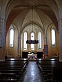
The église de Notre-Dame-des-Langueurs

The église de Notre-Dame-des-Langueurs


Heraldry[]
 |
The coat of arms of Joué-sur-Erdre is blazonned : D'or à la bande ondée d'azur. |
Parks[]
Joué-sur-Erdre hosts two lacs, the , and the « Little Vioreau » which regularize the water level of the Canal de Nantes à Brest.
Cultural events[]
Each year the commune celebrate the "Pardon".
Sports and leisure activities[]
The lake Vioreau allows people to practice several sport activities such as water sports with the ASS Cercle de Voile de Vioreau.
See also[]
- Communes of the Loire-Atlantique department
References[]
- ^ "Populations légales 2018". INSEE. 28 December 2020.
- ^ Jump up to: a b c Rostaing & Dauzat 1968
- ^ Joué-sur-Erdre sur KerOfis
- ^ Nègre 1990, p. 38.
- ^ "Quelles seront les principales communes concernées par l'élévation du niveau de la mer dans le département loire-atlantique, suite au réchauffement climatique ?". sos-climat.com (in French). Archived from the original on December 2, 2008. Retrieved March 24, 2009.
- ^ Map showing what happen if the sea level rose of 14 meters.
- ^ Jump up to: a b c d e f g h i j k l {{cite web Its Breton name is Yaoued. The Breton name of the people from Yaoued is Yaouedad (for men) and Yaouedadez (for women). |url=http://www.infobretagne.com/joue-sur-erdre.htm |title=Étymologie et histoire de Joué-sur-Erdre |work= infobretagne.com |access-date=March 15, 2009 }}
- ^ Jump up to: a b c d e f "Dossier complet: Commune de Joué-sur-Erdre (44077)". INSEE. June 2020. Retrieved August 31, 2020.
- ^ Jump up to: a b Dossier complet: France métropolitaine, INSEE
- ^ Source : JdN
- ^ Jump up to: a b Source : JdN
- ^ Jump up to: a b Source : JdN
- ^ "Liste des sites classés". site de la préfecture de la Loire-Atlantique. Archived from the original on December 6, 2008. Retrieved March 19, 2009.
- ^ "Sites Classés et Inscrits". site du ministère de l'écologie, Direction Régionale de l'Environnement des Pays de la Loire. Archived from the original on December 8, 2008. Retrieved March 19, 2009.
- ^ Des villages de Cassini aux communes d'aujourd'hui: Commune data sheet Joué-sur-Erdre, EHESS. (in French)
- ^ Population en historique depuis 1968, INSEE
- ^ "Établissements scolaires à Joué-sur-Erdre". aucoeurdesecoles.com. Archived from the original on October 7, 2011. Retrieved March 15, 2009.
External links[]
- Official website
- Joué-sur-Erdre on the IGN
- Joué on the Communauté de communes du pays d'Ancenis
- Aerial photos (Panoramio)
- Map.
- Census archives of Joué-sur-Erdre
| Wikimedia Commons has media related to Joué-sur-Erdre. |
- Communes of Loire-Atlantique