Saint-Brevin-les-Pins
Saint-Brevin-les-Pins | |
|---|---|
Commune | |
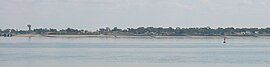 Coastline of Saint-Brevin-les-Pins, seen from Saint-Nazaire | |
 Coat of arms | |
show Location of Saint-Brevin-les-Pins | |
 Saint-Brevin-les-Pins | |
| Coordinates: 47°14′55″N 2°09′56″W / 47.2486°N 2.1656°WCoordinates: 47°14′55″N 2°09′56″W / 47.2486°N 2.1656°W | |
| Country | France |
| Region | Pays de la Loire |
| Department | Loire-Atlantique |
| Arrondissement | Saint-Nazaire |
| Canton | Saint-Brevin-les-Pins |
| Intercommunality | Sud-Estuaire |
| Government | |
| • Mayor (2020–2026) | Yannick Haury |
| Area 1 | 19.29 km2 (7.45 sq mi) |
| Population (Jan. 2018)[1] | 14,118 |
| • Density | 730/km2 (1,900/sq mi) |
| Time zone | UTC+01:00 (CET) |
| • Summer (DST) | UTC+02:00 (CEST) |
| INSEE/Postal code | 44154 /44250 |
| Elevation | 0–39 m (0–128 ft) |
| 1 French Land Register data, which excludes lakes, ponds, glaciers > 1 km2 (0.386 sq mi or 247 acres) and river estuaries. | |


Saint-Brevin-les-Pins (French pronunciation: [sɛ̃ bʁevɛ̃ le pɛ̃] (![]() listen); also Saint-Brévin-les-Pins; Breton: Sant-Brewenn) is a commune in the Loire-Atlantique department in western France.
listen); also Saint-Brévin-les-Pins; Breton: Sant-Brewenn) is a commune in the Loire-Atlantique department in western France.
Population[]
|
|
See also[]
- Communes of the Loire-Atlantique department
References[]
- ^ "Populations légales 2018". INSEE. 28 December 2020.
| Wikimedia Commons has media related to Saint-Brevin-les-Pins. |
| show Authority control |
|---|
This Loire-Atlantique geographical article is a stub. You can help Wikipedia by . |
Categories:
- Communes of Loire-Atlantique
- Loire-Atlantique geography stubs