Saint-Aubin-des-Châteaux
Saint-Aubin-des-Châteaux | |
|---|---|
Commune | |
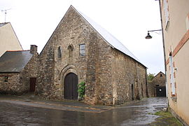 Chapel of the Templars | |
 Coat of arms | |
show Location of Saint-Aubin-des-Châteaux | |
 Saint-Aubin-des-Châteaux | |
| Coordinates: 47°43′15″N 1°29′06″W / 47.7208°N 1.485°WCoordinates: 47°43′15″N 1°29′06″W / 47.7208°N 1.485°W | |
| Country | France |
| Region | Pays de la Loire |
| Department | Loire-Atlantique |
| Arrondissement | Châteaubriant-Ancenis |
| Canton | Châteaubriant |
| Intercommunality | Châteaubriant-Derval |
| Government | |
| • Mayor (2020–2026) | Daniel Rabu |
| Area 1 | 47.56 km2 (18.36 sq mi) |
| Population (Jan. 2018)[1] | 1,784 |
| • Density | 38/km2 (97/sq mi) |
| Time zone | UTC+01:00 (CET) |
| • Summer (DST) | UTC+02:00 (CEST) |
| INSEE/Postal code | 44153 /44110 |
| Elevation | 32–92 m (105–302 ft) (avg. 65 m or 213 ft) |
| 1 French Land Register data, which excludes lakes, ponds, glaciers > 1 km2 (0.386 sq mi or 247 acres) and river estuaries. | |


Saint-Aubin-des-Châteaux is a commune in the Loire-Atlantique department in western France.
Geography[]
The village is located in the northwestern part of the commune on the right bank of the river Chère, which flows southwest through the commune.
Population[]
|
|
See also[]
- Communes of the Loire-Atlantique department
References[]
- ^ "Populations légales 2018". INSEE. 28 December 2020.
| Wikimedia Commons has media related to Saint-Aubin-des-Châteaux. |
This Loire-Atlantique geographical article is a stub. You can help Wikipedia by . |
Categories:
- Communes of Loire-Atlantique
- Loire-Atlantique geography stubs