Avessac
Avessac | |
|---|---|
Commune | |
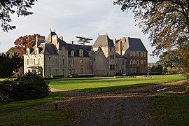 Château de Pordor | |
show Location of Avessac | |
 Avessac | |
| Coordinates: 47°39′15″N 1°59′18″W / 47.6542°N 1.9883°WCoordinates: 47°39′15″N 1°59′18″W / 47.6542°N 1.9883°W | |
| Country | France |
| Region | Pays de la Loire |
| Department | Loire-Atlantique |
| Arrondissement | Châteaubriant-Ancenis |
| Canton | Pontchâteau |
| Intercommunality | Redon Agglomération |
| Government | |
| • Mayor (2020–2026) | Hubert du Plessis |
| Area 1 | 76.49 km2 (29.53 sq mi) |
| Population (Jan. 2018)[1] | 2,468 |
| • Density | 32/km2 (84/sq mi) |
| Time zone | UTC+01:00 (CET) |
| • Summer (DST) | UTC+02:00 (CEST) |
| INSEE/Postal code | 44007 /44460 |
| Elevation | 0–81 m (0–266 ft) (avg. 76 m or 249 ft) |
| 1 French Land Register data, which excludes lakes, ponds, glaciers > 1 km2 (0.386 sq mi or 247 acres) and river estuaries. | |


Avessac is a commune in the Loire-Atlantique department in western France.
Population[]
| Year | Pop. | ±% |
|---|---|---|
| 1793 | 2,299 | — |
| 1800 | 2,012 | −12.5% |
| 1806 | 1,740 | −13.5% |
| 1821 | 2,084 | +19.8% |
| 1831 | 2,370 | +13.7% |
| 1836 | 2,339 | −1.3% |
| 1841 | 2,422 | +3.5% |
| 1846 | 2,464 | +1.7% |
| 1851 | 2,541 | +3.1% |
| 1856 | 2,489 | −2.0% |
| 1861 | 2,834 | +13.9% |
| 1866 | 3,210 | +13.3% |
| 1872 | 3,427 | +6.8% |
| 1876 | 3,425 | −0.1% |
| 1881 | 3,695 | +7.9% |
| 1886 | 3,647 | −1.3% |
| 1891 | 3,616 | −0.9% |
| 1896 | 3,703 | +2.4% |
| 1901 | 3,732 | +0.8% |
| 1906 | 3,678 | −1.4% |
| 1911 | 3,549 | −3.5% |
| 1921 | 3,098 | −12.7% |
| 1926 | 3,137 | +1.3% |
| 1931 | 3,042 | −3.0% |
| 1936 | 2,845 | −6.5% |
| 1946 | 2,759 | −3.0% |
| 1954 | 2,541 | −7.9% |
| 1962 | 2,496 | −1.8% |
| 1968 | 2,405 | −3.6% |
| 1975 | 2,356 | −2.0% |
| 1982 | 2,395 | +1.7% |
| 1990 | 2,233 | −6.8% |
| 1999 | 2,154 | −3.5% |
| 2006 | 2,357 | +9.4% |
| 2009 | 2,409 | +2.2% |
| 2017 | 2,476 | +2.8% |
See also[]
- Communes of the Loire-Atlantique department
References[]
- ^ "Populations légales 2018". INSEE. 28 December 2020.
| Wikimedia Commons has media related to Avessac. |
This Loire-Atlantique geographical article is a stub. You can help Wikipedia by . |
Categories:
- Communes of Loire-Atlantique
- Loire-Atlantique geography stubs