Sautron
Sautron | |
|---|---|
 L'hôtel de ville. | |
show Location of Sautron | |
 Sautron | |
| Coordinates: 47°15′52″N 1°40′00″W / 47.2644°N 1.6667°WCoordinates: 47°15′52″N 1°40′00″W / 47.2644°N 1.6667°W | |
| Country | France |
| Region | Pays de la Loire |
| Department | Loire-Atlantique |
| Arrondissement | Nantes |
| Canton | Saint-Herblain-1 |
| Intercommunality | Nantes Métropole |
| Government | |
| • Mayor (2020–2026) | Marie-Cécile Gessant[1] |
| Area 1 | 17.28 km2 (6.67 sq mi) |
| Population (Jan. 2018)[2] | 8,451 |
| • Density | 490/km2 (1,300/sq mi) |
| Demonym(s) | Sautronnaise, Sautronnais |
| Time zone | UTC+01:00 (CET) |
| • Summer (DST) | UTC+02:00 (CEST) |
| INSEE/Postal code | 44194 /44880 |
| Elevation | 25–80 m (82–262 ft) |
| Website | http://www.sautron.fr/ |
| 1 French Land Register data, which excludes lakes, ponds, glaciers > 1 km2 (0.386 sq mi or 247 acres) and river estuaries. | |


Sautron (French pronunciation: [sotʁɔ̃] (![]() listen); Breton: Saotron) is a commune in the Loire-Atlantique département in western France.
listen); Breton: Saotron) is a commune in the Loire-Atlantique département in western France.
Geography[]

Position of Sautron in the département of Loire-Atlantique
Sautron is located 10 km north west of Nantes, close to the Nantes-Vannes expressway.
Surrounding communes are Vigneux-de-Bretagne, Orvault, Saint-Herblain and Couëron.
According to the classification established by INSEE, Sautron is a commune urbaine (urban commune), one of 19 communes in the suburban area of Nantes.
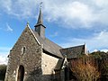
Sites and monuments[]

The church

The Château des Croix
Chapelle de Bongarant


See also[]
- Communes of the Loire-Atlantique department
References[]
- ^ "Répertoire national des élus: les maires". data.gouv.fr, Plateforme ouverte des données publiques françaises (in French). 2 December 2020. Retrieved 7 December 2020.
- ^ "Populations légales 2018". INSEE. 28 December 2020.
External links[]
| Wikimedia Commons has media related to Sautron. |
| show Authority control |
|---|
This Loire-Atlantique geographical article is a stub. You can help Wikipedia by . |
Categories:
- Communes of Loire-Atlantique
- Loire-Atlantique geography stubs