Kars
Kars | |
|---|---|
| Kars Municipality Kars Belediyesi | |
 Top: Cathedral of Kars, Castle of Kars (left to right) Bottom: Panorama view of Kars, overview of Karacaören from Kars Castle. | |
 Kars Location of Kars | |
| Coordinates: 40°36′28″N 43°05′45″E / 40.60778°N 43.09583°ECoordinates: 40°36′28″N 43°05′45″E / 40.60778°N 43.09583°E | |
| Country | |
| Region | Eastern Anatolia |
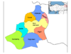
| Province | Kars |
| Government | |
| • Governor | Eyüp Tepe |
| • Acting Mayor | Eyüp Tepe (State-appointed trustee) |
| Area | |
| • District | 1,804.58 km2 (696.75 sq mi) |
| Elevation | 1,768 m (5,801 ft) |
| Population (2012)[2] | |
| • Urban | 78,100 |
| • District | 111,597 |
| • District density | 62/km2 (160/sq mi) |
| Time zone | UTC+3 (TRT) |
| Area code(s) | (+474) |
| Website | Kars Municipality |


Kars (Armenian: Կարս or Ղարս,[3] Kurdish: Qers,[4] Azerbaijani: Qars) is a city in northeast Turkey and the capital of Kars Province. Its population is 73,836 as of 2011.
Kars was in the ancient region known as Chorzene, (in Greek Χορζηνή) in classical historiography (Strabo), part of Kingdom of Armenia (antiquity),[5] in Ayrarat province.
Etymology[]
The city's name may be derived from the Armenian word հարս (hars), meaning "bride",[6] or from կառուց բերդ (kaṛuts berd), "Kaṛuts Fortress".[citation needed]. Another hypothesis has it that the name derives from the Georgian word კარი (kari), meaning "the gate" as was the case for other border region strongholds.[7][verification needed]
History[]
Medieval period[]
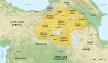
Little is known of the early history of Kars beyond the fact that, during medieval times, it had its own dynasty of Armenian rulers and was the capital of a region known as Vanand. Medieval Armenian historians referred to the city by a variety of names, including "Karuts' K'aghak'" (Kars city), "Karuts' Berd", "Amrots'n Karuts'" (both meaning Kars Fortress) and "Amurn Karuts'" (Impenetrable Kars).[3] At some point in the ninth century (at least by 888) it became part of the territory of the Armenian Bagratunis. Kars was the capital of Bagratid Kingdom of Armenia between 928 and 961.[8] During this period the town's cathedral, later known as the Church of the Holy Apostles, was built.[9]
In 963, shortly after the Bagratuni seat was transferred to Ani, Kars became the capital of a separate independent kingdom, again called Vanand. However, the extent of its actual independence from the Kingdom of Ani is uncertain: it was always in the possession of the relatives of the rulers of Ani, and, after Ani's capture by the Byzantine Empire in 1045, the Bagratuni title "King of Kings" held by the ruler of Ani was transferred to the ruler of Kars. In 1064, just after the capture of Ani by Alp Arslan (leader of the Seljuk Turks), the Armenian king of Kars, Gagik-Abas, paid homage to the victorious Turks so that they would not lay siege to his city. In 1065 Gagik-Abas ceded his kingdom to the Byzantine Empire, but soon after Kars was taken by the Seljuk Turks.[3]
The Seljuks quickly relinquished direct control over Kars and it became a small emirate whose territory corresponded closely to that of Vanand, and which bordered the similarly created but larger Shaddadid emirate centered at Ani. The Kars emirate was a vassal of the Saltukids in Erzurum, whose forces were effective in opposing Georgian attempts at seizing Kars. Thus, it was only in 1206 that Zakare of the Zakarids-Mkhargrzeli succeeded in capturing Kars, joining it to their fiefdom of Ani.[10] It was conquered in 1242 by the Mongols; was regained by Georgian Kingdom during the reign of George V the Brilliant (1314–1346), it remained part of the Kingdom before its disintegration, which then passed into the hands of Georgian Atabegs belonging to the House of Jaqeli.[citation needed] In 1387 the city surrendered to Timur (Tamerlane) and its fortifications were damaged. Anatolian beyliks followed for some time after that, until it firstly fell into the hands of the Kara Koyunlu and subsequent Ak Koyunlu. After the Ak Koyunlu, as it went naturally for almost all their former territories, the city fell into the hands of the newly established Safavid dynasty of Iran, founded by king Ismail I. Following the Peace of Amasya of 1555 that followed through the Ottoman-Safavid War of 1533-1555, the city was declared neutral, and its existing fortress was destroyed.[11][12] In 1585, during the Ottoman-Safavid War of 1579-1590, the Ottomans took the city alongside Tabriz.[13] On June 8, 1604, during the next bout of hostilities between the two archrivals, the Ottoman-Safavid War of 1603-1618, Safavid ruler Abbas I retook the city from the Ottomans.[14] The fortifications of the city were rebuilt by the Ottoman Sultan Murad III and were strong enough to withstand a siege by Nader Shah of Persia, in 1731.[15] It became the head of a sanjak in the Ottoman Erzurum Vilayet.[15] In August 1745, a huge Ottoman army was routed at Kars by Nader Shah during the Ottoman-Persian War of 1743-1746.[16] As a result, the Turks fled westwards, raiding their own lands as they went.[16]
Russian administration[]


In 1807 Kars successfully resisted an attack by the Russian Empire. During a break between the Russian campaigns in the region conducted against the Ottomans, in 1821, commander-in-chief Abbas Mirza of Qajar Iran occupied Kars,[17] further igniting the Ottoman-Persian War of 1821-1823. After another Russian siege in 1828 the city was surrendered by the Ottomans on June 23, 1828 to the Russian general Count Ivan Paskevich, 11,000 men becoming prisoners of war.[15] At the end of the war it returned to Ottoman control for diplomatic reasons, Russia gaining only two border forts. During the Crimean War an Ottoman garrison led by British officers including General William Fenwick Williams kept the Russians at bay during a protracted siege; but after the garrison had been devastated by cholera and food supplies had depleted, the town was surrendered to General Mouravieff in November 1855.[15]
The city's significance increased as the Ottoman and Russian empires contested its possession. The fortress was stormed by the Russians in the Battle of Kars during the Russo-Turkish War, 1877-78[15] under generals Loris-Melikov and Ivan Lazarev. Following the war, Kars was transferred to Russia by the Treaty of San Stefano. Kars became the capital of the Kars Oblast (province), comprising the districts of Kars, Ardahan, Kaghisman, and Oltu, which was the most southwesterly extension of the Russian Transcaucasus. In the following years the Russians supported the fortification of Kars.[18]
From 1878 to 1881 more than 82,000 Muslims from formerly Ottoman-controlled territory migrated to the Ottoman Empire. Among those there were more than 11,000 people from the city of Kars. At the same time, many Armenians and Pontic Greeks (here usually called Caucasus Greeks) migrated to the region from the Ottoman Empire and other regions of Transcaucasia. According to the Russian census data, by 1897 Armenians formed 49.7%, Russians 26.3%, Caucasus Greeks 11.7%, Poles 5.3% and Turks 3.8%.[19]
World War I[]

In the First World War, the city was one of the main objectives of the Ottoman army during the lost Battle of Sarikamish in the Caucasus Campaign. Russia ceded Kars, Ardahan and Batum to the Ottoman Empire under the Treaty of Brest-Litovsk on 3 March 1918. However, by then Kars was under the effective control of Armenian and non-Bolshevik Russian forces. The Ottoman Empire captured Kars on 25 April 1918,[20] but under the Armistice of Mudros (October 1918) was required to withdraw to the pre-war frontier[21] and Kars came under control of the First Republic of Armenia.[22] The Ottomans refused to relinquish Kars; its military governor instead established a government, the Provisional National Government of the Southwestern Caucasus, led by Fahrettin Pirioglu, that claimed Turkish sovereignty over Kars and Turkic-speaking regions as far as Batumi and Alexandropol (Gyumri). Much of the region fell under the administrative control of Armenia in January 1919 but the pro-Turkish government remained in the city until a joint operation launched by British and Armenian troops dissolved it on 19 April 1919, arresting its leaders and sending them to Malta.[23] In May 1919 Kars came under the full administration of the Armenian Republic and became the capital of its Vanand province.
Skirmishes between the Turkish revolutionaries and Armenian border troops in Olti took place during the summer of 1920. In the autumn of that year four Turkish divisions under the command of General Kâzım Karabekir invaded the Armenian Republic, triggering the Turkish-Armenian War.[24] Kars had been fortified to withstand a lengthy siege but, to the astonishment of all, was taken with little resistance by Turkish forces on 30 October 1920, in what some modern scholars have called one of the worst military fiascoes in Armenian history.[25] The terms of the Treaty of Alexandropol, signed by the representatives of Armenia and Turkey on 2 December 1920, forced Armenia to give back all the Ottoman territories granted to it in the Treaty of Sèvres.
After the Bolshevik advance into Armenia, the Treaty of Alexandropol was superseded by the Treaty of Kars (October 23, 1921), signed between Turkey and the Soviet Union. The treaty allowed for Soviet annexation of Adjara in exchange for Turkish control of the regions of Kars, Igdir, and Ardahan. The Treaty of Kars established peaceful relations between the two nations, but as early as 1939, some British diplomats noted[citation needed] indications that the Soviet Union was not satisfied with the established border. The Treaty of Kars, signed in 1921 by the Government of the Grand National Assembly and by the Soviet republics of Armenia, Azerbaijan and Georgia, established the current north-eastern boundaries of Turkey. The treaty included de jure provisions guaranteeing the Armenian residents right to relinquish Turkish nationality, leave the territory freely and take with them either their goods or the proceeds of their sale, but by some accounts formerly Armenian lands had de facto become state property as a consequence of the treaty.[26]
After World War II[]

After World War II, the Soviet Union attempted to annul the Kars treaty and regain the Kars region and the adjoining region of Ardahan. On June 7, 1945, Soviet Foreign Minister Vyacheslav Molotov told the Turkish ambassador to Moscow Selim Sarper that the regions should be returned to the Soviet Union, on behalf of the Georgian and Armenian republics. Turkey found itself in a difficult position: it wanted good relations with the Soviet Union, but at the same time they refused to give up the territories. Turkey itself was in no condition to fight a war with the Soviet Union, which had emerged as a superpower after the second world war. By the autumn of 1945, Soviet troops in the Caucasus were ordered to prepare for a possible invasion of Turkey. Prime Minister Winston Churchill objected to these territorial claims, while President Harry Truman initially felt that the matter should not concern other parties. With the onset of the Cold War, however, the United States came to see Turkey as a useful ally against Soviet expansion and began to support it financially and militarily. By 1948 the Soviet Union dropped its claims to Kars and the other regions.[27]
Recent history[]
In April 1993, Turkey closed its Kars border crossing with Armenia, in a protest against the capture of Kelbajar district of Azerbaijan by Armenian forces during the First Nagorno-Karabakh War.[28] Since then the land border between Armenia and Turkey has remained closed. In 2006, former Kars mayor Naif Alibeyoğlu said that opening the border would boost the local economy and reawaken the city.[29] Despite unsuccessful attempts to establish diplomatic relations between the two countries in 2009,[30] there remained opposition and pressure from the local population against the re-opening of the border.[31] Under pressure from Azerbaijan, and the local population, including the 20% ethnic Azerbaijani minority, the Turkish foreign minister Ahmet Davutoğlu reiterated in 2010 and 2011 that opening the border with Armenia was out of question.[32][33] As of 2014, the border remains closed.[34]
The last elected mayor of Kars was Ayhan Bilgen of the Peoples' Democratic Party (HDP), who was elected in 2019, and arrested and deposed in 2020. He was replaced by the governor of Kars Province, Eyüp Tepe, as a government-appointed trustee.[35][36][37][38]
Demographics[]
According to Turkey's 2011 Statistical Yearbook, the area has been depopulating because of migration to bigger cities.[39] In Istanbul alone, there are 269,388 people from Kars, more than three times the city's population.[40][41]
Today, Kars has a mixed population of Azerbaijanis, Kurds and Turks.[32]
The Azerbaijanis are mainly composed of the Terekeme and Qarapapaq sub-ethnic groups.[42] The Shia Azerbaijanis make up 20% of the city's population.[43]
Most of the population in Kars is Sunni Muslim, mainly the Kurds and Turks, and the minority is Shiite Muslim, mainly among the Azerbaijanis.
| Year | Total | Turks | Armenians | Others |
|---|---|---|---|---|
| 1878[44] | 4,244 | 2,835 (66.8%) | 1,031 (24.4%) | 378 Caucasus Greeks (8.9%) |
| 1886[45] | 3,939 | 841 (21.4%) | 2,483 (63%) | 322 Caucasus Greeks (8.2%), 247 Russians (6.3%) |
| 1897[19] | 20,805 | 786 (3.8%) | 10,332 (49.7%) | 5,478 Russians (26.3%), 1,084 Poles (5.2%), 733 Caucasus Greeks (3.5%), 486 Tatars (2.3%) |
| 1916[46] | 30,514 | 1,210 (3.9%) | 25,665 (84.1%) | 1,487 Russians (4.9%), 1,828 other Christians (5.9%), 298 other Muslims, 25 Jews |
| 1970[3] | 54,000 | |||
| 1990[47] | 78,455 | |||
| 2000[48] | 78,473 | |||
| 2013[48] | 78,101 |
Government[]


The ethnic make-up of Kars is also reflected in politics, with the Turks and Azerbaijanis often voting for the nationalist MHP and the Kurds often voting for the pro-Kurdish HDP. On 30 March 2014, Murtaza Karaçanta (MHP) was elected mayor. During the June 2015 elections, Kars was won by the pro-Kurdish HDP, becoming the largest political party in both the city and the province of Kars. The last elected mayor was Ayhan Bilgen from the HDP until he was deposed in October 2020.[35]
Climate[]
Kars has a humid continental climate (Köppen: Dfb, Trewartha: Dcb). It experiences significant seasonal and diurnal temperature variation, due to its location away from large bodies of water, its high elevation and location, where the high plateau of Eastern Anatolia converges with the Lesser Caucasus mountain range.
Summers are generally brief and quite warm with cool nights. The average high temperature in August is 27 °C (81 °F).
Winters are very cold. The average low January temperature is −15 °C (5 °F), and temperatures can plummet to −30 °C (−22 °F) during the winter months. Kars experiences frequent and sometimes heavy snowfall, with four months of snow cover on average.[citation needed]
Due to its geographical location, the city itself has a slightly milder climate compared to the surrounding region. Some hills and peaks in the province, especially around the Sarıkamış region, are subarctic (Köppen: Dfc, Trewartha: Ec) due to the higher elevation of the region. Summers and winters are colder in these areas, with winter temperatures reaching −40 °C (−40 °F) more regularly.[citation needed]
| hideClimate data for Kars (1991–2020, extremes 1931–2020) | |||||||||||||
|---|---|---|---|---|---|---|---|---|---|---|---|---|---|
| Month | Jan | Feb | Mar | Apr | May | Jun | Jul | Aug | Sep | Oct | Nov | Dec | Year |
| Record high °C (°F) | 8.4 (47.1) |
12.0 (53.6) |
19.1 (66.4) |
25.0 (77.0) |
27.0 (80.6) |
31.6 (88.9) |
35.4 (95.7) |
35.4 (95.7) |
32.6 (90.7) |
26.8 (80.2) |
21.9 (71.4) |
15.9 (60.6) |
35.4 (95.7) |
| Average high °C (°F) | −3.2 (26.2) |
−1.2 (29.8) |
4.9 (40.8) |
12.3 (54.1) |
17.3 (63.1) |
22.2 (72.0) |
26.3 (79.3) |
27.3 (81.1) |
23.0 (73.4) |
16.1 (61.0) |
7.5 (45.5) |
−0.4 (31.3) |
12.7 (54.9) |
| Daily mean °C (°F) | −9.4 (15.1) |
−7.7 (18.1) |
−1.0 (30.2) |
5.7 (42.3) |
10.4 (50.7) |
14.5 (58.1) |
17.9 (64.2) |
18.4 (65.1) |
14.1 (57.4) |
8.2 (46.8) |
0.6 (33.1) |
−6.2 (20.8) |
5.5 (41.9) |
| Average low °C (°F) | −14.8 (5.4) |
−13.4 (7.9) |
−6.3 (20.7) |
−0.2 (31.6) |
4.3 (39.7) |
7.4 (45.3) |
10.5 (50.9) |
10.7 (51.3) |
6.1 (43.0) |
1.5 (34.7) |
−4.8 (23.4) |
−11.2 (11.8) |
−0.8 (30.6) |
| Record low °C (°F) | −36.7 (−34.1) |
−37.0 (−34.6) |
−31.5 (−24.7) |
−22.6 (−8.7) |
−7.0 (19.4) |
−4.0 (24.8) |
0.1 (32.2) |
−1.9 (28.6) |
−4.4 (24.1) |
−17.5 (0.5) |
−30.0 (−22.0) |
−35.0 (−31.0) |
−37.0 (−34.6) |
| Average precipitation mm (inches) | 23.2 (0.91) |
21.4 (0.84) |
33.1 (1.30) |
57.0 (2.24) |
83.6 (3.29) |
75.0 (2.95) |
65.1 (2.56) |
45.1 (1.78) |
29.7 (1.17) |
44.6 (1.76) |
26.6 (1.05) |
25.6 (1.01) |
530.0 (20.87) |
| Average precipitation days | 6.77 | 6.00 | 8.37 | 12.70 | 17.57 | 12.93 | 10.57 | 9.33 | 7.13 | 10.03 | 6.40 | 6.97 | 114.8 |
| Average relative humidity (%) | 83 | 85 | 78 | 68 | 65 | 65 | 63 | 55 | 57 | 62 | 73 | 83 | 70 |
| Mean monthly sunshine hours | 105.4 | 132.8 | 164.3 | 183.0 | 226.3 | 273.0 | 316.2 | 303.8 | 249.0 | 192.2 | 147.0 | 102.3 | 2,395.3 |
| Mean daily sunshine hours | 3.4 | 4.7 | 5.3 | 6.1 | 7.3 | 9.1 | 10.2 | 9.8 | 8.3 | 6.2 | 4.9 | 3.3 | 6.5 |
| Source 1: Turkish State Meteorological Service[49] | |||||||||||||
| Source 2: Weatherbase[50] | |||||||||||||
Sports[]
The town has a football club Kars S.K.. Bandy, a sport which does not exist in Turkey today, was once played here.[51]
Education[]
Kars hosts the Kafkas University, which was established in 1992.[52]
Transport[]

Kars is served by a main highway from Erzurum, and lesser roads run north to Ardahan and south to Igdir. The town has an airport (Kars Harakani Airport), with daily direct flights to Ankara and Istanbul. Kars is served by a station on the Turkish Railways (TCDD) that links it to Erzurum. This line was originally laid when Kars was within the Russian Empire and connected the city to nearby Alexandropol and Tiflis, with a wartime, narrow-gauge extension running to Erzurum. Turkey's border crossings with Armenia, including the rail link, the Kars-Gyumri-Tbilisi railway, have regrettably been closed since April 1993. Turkey's border with Armenia was closed down after Armenia occupied the Nagorno Karabakh region in Azerbaijan. (As of September 2018, Turkey maintains that the border will remain closed until Armenia ends its occupation).[53] Construction on a new line, the Kars–Tbilisi–Baku railway, intended to connect Turkey with Georgia and Azerbaijan, began in 2010. The line became operational on October 30, 2017.[54] The line connects Kars to Akhalkalaki in Georgia, from where trains will continue to Tbilisi, and Baku in Azerbaijan.[55]
Places of interest[]
Kars Citadel[]

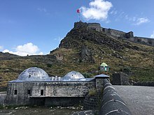
The Castle of Kars (Turkish: Kars Kalesi), also known as the Citadel, sits at the top a rocky hill overlooking Kars. Its walls date back to the Bagratuni Armenian period (there is surviving masonry on the north side of the castle) but it probably took on its present form during the thirteenth century when Kars was ruled by the Zak'arid dynasty.
The walls bear crosses in several places, including a Khachkar with a building inscription in Armenian on the easternmost tower, so the much repeated statement that Kars castle was built by Ottoman Sultan Murad III during the war with Persia, at the close of the sixteenth century, is inaccurate. However, Murad probably ordered to reconstruct much of the city walls (they are similar to those that the Ottoman army constructed at Ardahan). During the eighteenth century at the Battle of Kars (1745) a crushing defeat was inflicted upon the Ottoman army by the Persian conqueror, Nader Shah, not far from the city of Kars.
By the nineteenth century the citadel had lost most of its defensive purpose and a series of outer fortresses and defensive works were constructed to encircle Kars – this new defensive system proved particularly notable during the Siege of Kars in 1855.
Other historical structures[]


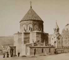
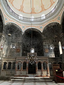
Below the castle is a mosque, formerly the Armenian church known as Surb Arak'elots, the Church of the Holy Apostles. Built in the 930s, it has a tetraconch plan (a square with four semicircular apses) surmounted by a spherical dome on a cylindrical drum. On the exterior, the drum of contains bas-relief depictions of twelve figures, usually interpreted as representing the Twelve Apostles. The dome has a conical roof. The church was converted to a mosque in 1579, and then converted into a Russian Orthodox church in the 1880s. The Russians built porches in front of the church's three entrances, and an elaborate clocktower (now demolished) next to the church. The church was used as a warehouse from the 1930s, and it housed a small museum from 1963 until the late 1970s. Then the building was left to itself for about two decades, until it was converted into a mosque in 1993. In the same district of Kars are two other ruined Armenian churches. A Russian church from the 1900s was converted to a mosque in the 1980s after serving as a school gymnasium.[57]
The Grand Mosque of Kars is the largest historic mosque in the city. Built by the Seljuks, it was restored by the Ottomans in 1579.
The "Taşköprü" (Stone Bridge) is a bridge over the Kars river, built in 1725. Close to the bridge are three old bath-houses, none of them operating any longer.
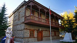
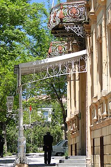
As a settlement at the juncture of Turkish, Armenian, Georgian, Kurdish and Russian cultures, the buildings of Kars come in a variety of architectural styles. Most Russian-era buildings in Kars are identical in architectural style to those of Gyumri in Armenia. Orhan Pamuk in the novel Snow, set in Kars, makes repeated references to "the Russian houses", built "in a Baltic style"[citation needed], whose like cannot be seen anywhere else in Turkey, and deplores the deteriorating condition of these houses.
- The Mansion of Ahmet Tevfik Pasha (Ahmet Tevfik Paşa Konağı)
- The Stone Bridge (Taşköprü)
- The Topchuoglu Bath House (Topçuoğlu Hamamı)
- The Ilbeoglu Bath House (İlbeyoğlu Hamamı)
- The Mazlumaga Bath House (Mazlumağa Hamamı)
- The House of Namık Kemal (Namık Kemal Evi)
- The Palace of Beylerbeyi (Beylerbeyi Sarayı)
- The Mansion of Pasha (Paşa Konağı)
- The Cemetery of Arap Baba (Arap Baba Şehitliği)
- The Mosque of Yusuf Pasha (Yusuf Paşa Camii)
- The Mosque of Evliya (Evliya Camii)
- The Tomb of Ebul Hasan-i Harakani (Ebul Hasan-i Harakani Türbesi)
- The Mosque of Fethiye (Fethiye Camii)
- The Mansion of Gazi Ahmet Muhtar Pasha (Gazi Ahmet Paşa Konağı)
Notable natives[]

- Abas I of Armenia, Armenian king
- Atrpet (1860–1937), Armenian novelist and writer
- Hayran-î-Dil Kadınefendi (1846–1898), wife of Ottoman sultan Abdülaziz and mother of Sultan Abdülmecid II
- İbrahim Aydın (1874–1948), military leader and civil servant
- Ivan Isakov (1894–1967), Soviet Armenian military commander, chief of staff and Admiral of the Fleet in the Soviet Navy
- Yeghishe Charents (1897–1937), Armenian poet
- Hovhannes Zardaryan (1918–1992), Armenian painter
- Varlam Avanesov, Armenian bolshevik politician
- Kelime Aydın Çetinkaya (1982), cross country skier
- Gülsüm Tatar (1985), world and European champion female boxer
- – famous Turkish actress and model; 1997 Miss Turkey winner of Azerbaijani descent
- Yavuz Bingöl – famous Turkish folk music singer and actor
- Tamer Karadağlı – a Turkish actor
- Gökhan Saki – K1 Fighter
- Emine Evdal, Kurdish writer
- Qenatê Kurdo, Kurdish writer
- Peter Makaroff (1894 – 1970), politician, peace activist, and world federalist
International relations[]
Twin towns – Sister cities[]
The municipality of Kars has developed sister city relationships with following cities at home and abroad:[58]
In popular culture[]
- Kars is the setting of the 2002 novel Kar (Snow) by Orhan Pamuk.
- Yerkir Nairi (Երկիր Նաիրի) novel by Yeghishe Charents is dedicated to the public persons and places of Kars.
- Modest Mussorgsky composed the march "The Capture of Kars" to commemorate Russia's victory there in 1855.
- The film Kosmos (Cosmos) by Reha Erdem was filmed in and around Kars.
- In 1857 the settlement of Wellington in Ontario, Canada renamed itself Kars in honor of the Canadian-born General William Fenwick Williams who organized the defense of Kars during its 1855 siege.
References[]
- ^ "Area of regions (including lakes), km²". Regional Statistics Database. Turkish Statistical Institute. 2002. Retrieved 2013-03-05.
- ^ "Population of province/district centers and towns/villages by districts - 2012". Address Based Population Registration System (ABPRS) Database. Turkish Statistical Institute. Retrieved 2013-02-27.
- ^ Jump up to: a b c d Arakelyan, Babken; Vardanyan, Vrezh; Khalpakhchyan, Hovhannes (1979). "Կարս [Kars]". Armenian Soviet Encyclopedia Volume 5 (in Georgian). Yerevan: Armenian Encyclopedia. pp. 342–343.
- ^ Adem Avcıkıran (2009). Kürtçe Anamnez Anamneza bi Kurmancî (PDF) (in Turkish and Kurdish). p. 57. Retrieved 17 December 2019.
- ^ Strabo. "Geography Stabo - Book XI - Chapter XIV". Retrieved 2011-05-30.
- ^ Room, Adrian (2003). Placenames of the World. McFarland. p. 178. ISBN 0-7864-1814-1.
- ^ Ring, Trudy; Salkin, Robert M.; La Boda, Sharon (1996). International Dictionary of Historic Places: Southern Europe. Taylor & Francis. p. 357. ISBN 1-884964-02-8.
- ^ Bloom, Jonathan M.; Blair, Sheila, eds. (2009). The Grove Encyclopedia of Islamic Art and Architecture, Volume 3. Oxford: Oxford University Press. p. 371. ISBN 978-0-19-530991-1.
- ^ (in Armenian) Harutyunyan, Varazdat M. "Chartarapetutyun" [Architecture] in Hay Zhoghovrdi Patmutyun [History of the Armenian People], eds. Tsatur Aghayan et al. Yerevan: Armenian Academy of Sciences, 1976, vol. 3, pp. 374–375.
- ^ Lordkipanidze & Hewitt 1987, p. 135.
- ^ Mikaberidze, Alexander Conflict and Conquest in the Islamic World: A Historical Encyclopedia, Volume 1. ABC-CLIO, 31 jul. 2011 ISBN 1598843362 p 698
- ^ Mikaberidze, Alexander (2015). Historical Dictionary of Georgia (2 ed.). Rowman & Littlefield. p. xxxi. ISBN 978-1442241466.
- ^ Endress, Gerhard Islam: An Historical Introduction page 194. Edinburgh University Press, 2002 ISBN 978-0748616206
- ^ Somel, Selcuk Aksin. (2003). Historical Dictionary of the Ottoman Empire page XXXV. Scarecrow Press, 13 feb. 2003 ISBN 978-0810866065
- ^ Jump up to: a b c d e Chisholm, Hugh, ed. (1911). . Encyclopædia Britannica. 15 (11th ed.). Cambridge University Press. p. 683.
- ^ Jump up to: a b Kohn, George Childs. "Dictionary of Wars" Routledge, 2013. ISBN 978-1135954949 p 506
- ^ Aksan, Virginia. Ottoman Wars, 1700-1870: An Empire Besieged Routledge, 2014, p. 463 ISBN 978-1317884033
- ^ Erickson, Edward J. (2001). Ordered to Die: A History of the Ottoman Army in the First World War. Greenwood Publishing Group. pp. 184. ISBN 978-0-313-31516-9.
- ^ Jump up to: a b Первая всеобщая перепись населения Российской Империи 1897 г. Распределение населения по родному языку и уездам Российской Империи кроме губерний Европейской России (in Russian). Demoscope Weekly. Retrieved 8 April 2014.
- ^ admina. "The Fall of Kars – April 25, 1918 | Aniarc". Retrieved 2020-04-03.
- ^ "The Armistice Convention with Turkey" (PDF). germanhistorydocs.ghi-dc. Retrieved 3 April 2020.
- ^ Hovannisian, Richard G. (1971). The Republic of Armenia: The first year, 1918-1919. University of California Press. pp. 222. ISBN 978-0-520-01805-1.
- ^ Hovannisian, Richard G. (1971). The Republic of Armenia, Vol. I: The First Year, 1918–1919. Berkeley: University of California Press. pp. 197–227. ISBN 0-520-01984-9.
- ^ Hovannisian, Richard G. (1996). The Republic of Armenia, Vol. IV: Between Crescent and Sickle, Partition and Sovietization. Berkeley: University of California Press. pp. 182ff. ISBN 0-520-08804-2.
- ^ Hovannisian. Republic of Armenia, Vol. IV, pp. 253–261.
- ^ Morack, Ellinor (2017-03-14). The Dowry of the State?: The Politics of Abandoned Property and the Population Exchange in Turkey 1921-1945. University if Bamberg Press. p. 167. ISBN 9783863094638.
- ^ Krikorian, Robert O. (2011), "Kars-Ardahan and Soviet Armenian Irredentism, 1945–1946," in Armenian Kars and Ani, ed. Richard G. Hovannisian. Costa Mesa, CA: Mazda Publishers, pp. 393–409.
- ^ Panico, Christopher; Rone, Jemera (1994). Bloodshed in the Caucasus: Escalation of the Armed Conflict in Nagorno Karabakh. Human Rights Watch/Helsinki Watch. p. 74. ISBN 1-56432-142-8.
Turkey cut all routes to Armenia in April 1993, after the Karabakh Armenian army - with alleged support from Russian and Armenian armies - seized Kelbajar province of Azerbaijan.
- ^ "Kars battles for access to Armenia and beyond", Turkish Daily News, July 30th 2006.
- ^ Staff (11 October 2009). "Turkey, Armenia to Reopen Border". The Wall Street Journal. Archived from the original on 12 October 2009.
- ^ Mammadli, Sabuhi (1 May 2009). "Border Turks Want Door to Armenia Kept Shut". CRS Issue 491. Institute for War and Peace Reporting. Archived from the original on 23 September 2012. Note: archive not available until mid-2013.
- ^ Jump up to: a b "Armenia border opening out of question, says Davutoğlu". Today's Zaman. 19 July 2010. Archived from the original on 23 September 2012. Note: archive not available until mid-2013.
- ^ "Two vast and ugly blocks of stone". The Economist. 13 January 2011.
- ^ "Turkish, Armenian journalists want the border opened". Today's Zaman. 3 June 2012. Archived from the original on 23 September 2012. Note: archive not available until mid-2013.
- ^ Jump up to: a b "Kars Seçim Sonuçları - 31 Mart 2019 Yerel Seçimleri". www.sabah.com.tr. Retrieved 2019-09-12.
- ^ "Turkish police detain dozens of HDP members, including Mayor Bilgen, over 2014 Kobane protests". www.duvarenglish.com. Retrieved 2020-09-25.
- ^ "Ayhan Bilgen sacked by the ministry of Interior". Milliyet (in Turkish). 2020-10-02. Retrieved 2020-10-02.
- ^ "Trustee replaces Kars mayor dismissed in pro-PKK probe targeting 2014 Kobani riots". Daily Sabah. Retrieved 2020-10-02.
- ^ Turkish Statistical Institute (2011). "The provinces with highest out-migration according to their net migration rate" (pdf). Turkey in Statistics 2011 (The Summary of Turkey's Statistical Yearbook 2011). p. 15.
- ^ "İstanbul'un nüfus bilgileri açıklandı". Sabah.
- ^ "Archived copy". Archived from the original on 2014-03-13. Retrieved 2014-03-13.CS1 maint: archived copy as title (link)
- ^ (in Russian) Azeris. Great Soviet Encyclopedia
- ^ "Two vast and ugly blocks of stone". economist.com. The Economist. 13 January 2011. Retrieved 29 January 2021.
- ^ Mirzoyan, Sonya; Badem, Candan (2013). The Construction of the Tiflis-Aleksandropol-Kars Railway (1895-1899): [English]. Institute for Historical Justice and Reconciliation. p. 7. ISBN 9789491145032.
At the end of 1878, the indigenous population of the city of Kars included 2,835 Turks, 1,031 Armenians and. 378 Greeks.
- ^ Свод статистических данных о населении Закавказского края, извлечённых из посемейных списков 1886 года, г. Тифлис, 1893. Available online here
- ^ Caucasian Calendar, 1916. pp. 198-201
- ^ The new encyclopædia Britannica, Volume 6, p. 751
- ^ Jump up to: a b "Kars". Encyclopædia Britannica. Archived from the original on 8 April 2014.
Pop. (2000) 78,473; (2013 est.) 78,100.
- ^ "Resmi İstatistikler: İllerimize Ait Mevism Normalleri (1991–2020)" (in Turkish). Turkish State Meteorological Service. Retrieved 11 April 2021.
- ^ "Kars, Turkey Travel Weather Averages (Weatherbase)". Weatherbase.
- ^ Grigoryan, Aleksandr. В хоккей играют настоящие армяне. Noev Kovcheg (in Russian). Archived from the original on 8 April 2014.
- ^ "Kafkas University - Kafkas". www.admissionglobal.com. Retrieved 2017-11-03.
- ^ "Turkey will not open Armenia border amid Karabakh occupation: Erdoğan - Turkey News". Hürriyet Daily News.
- ^ "Baku-Tbilisi-Kars (BTK) railway track becomes operational to carry Chinese goods to Europe". dnd.com.pk. 30 October 2017. Retrieved 27 February 2018.
- ^ Railway Gazette International February 2009 p54 with map
- ^ "Burası cami oldu, burada ayin olmaz". Milliyet (in Turkish). 2008-06-24.
Vakıflar Genel Müdürlüğü, 1993 yılında kiliseyi Diyanet İşleri Başkanlığı'na devretti. Böylece kilise, yıllar yine cami olarak kullanılmaya başlandı ve adı yine Kümbet Cami olarak değiştirildi.
- ^ "THE CATHEDRAL OF KARS: Holy Apostles Church (Surb Arak'elots)." VirtualANI. December 7, 2000.
- ^ "Kars Belediyesi'nin çalışmaları" (in Turkish). Siyasal Birikim. 8 October 2007. Archived from the original on 8 April 2014. Retrieved 8 April 2014.
68- KARDEŞ ŞEHİR: Belediyemiz Kardeş Şehir İlişkisi kurulması konusunda gerekli girişimlerde bulunarak yurt içinde Bursa ve Edirne Belediyeleri ile yurt dışında ise Azerbaycan'ın Gence Belediyesi, Almanya'nın Wesel Belediyesi, Norveç'in Kirkenes Belediyesi, Gürcistan'ın Kutaisi Belediyesi ile kardeş şehir ilişkisi kurulmuştur.
- ^ "Twin-cities of Azerbaijan". Azerbaijans.com. Retrieved 2013-08-09.
Further reading[]
- Gurallar, Neşe (2020). "Russian Modernization in East Anatolia: The Case of Kars". Muqarnas Online. 37 (1): 247–264. doi:10.1163/22118993-00371P09.
External links[]
| Wikimedia Commons has media related to Kars. |
| Wikivoyage has a travel guide for Kars. |
- Pictures of the city and the nearby city of Ani
- 700+ pictures of city, Kümbet Camii, Kale and Ani
- Kars Governor's Office
- The official city guide of the Kars municipality
- Kars News
- Kars Guide and Photo Album by Luc Wouters
- Kars Weather Forecast Information
- Treaty of Kars
- Atlas of Conflicts: The Treaty of Kars and Its Geopolitical Implications on Armenia by Dr. Andrew Andersen, Ph.D.
- VirtualANI - A history and description of the city of Kars
- Armenian History and Presence in Kars
- HitchHikers Handbook's guide to Kars
- 3D Model of the Cathedral
- Kars preservation project summary at Global Heritage Fund
- Explore Kars with Google Earth on Global Heritage Network
- Awarded "EDEN - European Destinations of Excellence" non traditional tourist destination 2009
| show Kars in Kars Province of Turkey |
|---|
| show Authority control |
|---|
- Kars
- Armenian Highlands
- Former capitals of Armenia
- Districts of Kars Province
- Kurdish settlements in Turkey