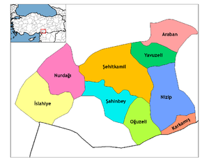
İslâhiye
Islahiye | |
|---|---|
 Islahiye Location of Islahiye in Turkey | |
| Coordinates: 37°01′30″N 36°38′04.20″E / 37.02500°N 36.6345000°ECoordinates: 37°01′30″N 36°38′04.20″E / 37.02500°N 36.6345000°E | |
| Country | |
| Region | Southeastern Anatolia |
| Province | Gaziantep |
| Government | |
| • Mayor | Kemal Vural (AKP) |
| Area | |
| • District | 817.65 km2 (315.70 sq mi) |
| Population (2012)[2] | |
| • Urban | 32,342 |
| • District | 66,193 |
| • District density | 81/km2 (210/sq mi) |
| Time zone | UTC+2 (EET) |
| • Summer (DST) | UTC+3 (EEST) |
| Postal code | 27800 |
| Area code(s) | +(90)342 |
| Website | islahiye.bl.tr |

Districts of Gaziantep
Islahiye is a town and district of Gaziantep Province in southeastern Turkey. It is a railway border crossing into Syria. Near İslâhiye is the site of ancient Nicopolis.[3]
The railway station of Islahiye is the last stop on the railway to Damascus in Syria. Since March 2001, a regular train line runs once a week between Syria and Iran via Islahiye.[4]
The state road ![]() D.825, which connects Gaziantep with Antakya, runs through Islahiye.
D.825, which connects Gaziantep with Antakya, runs through Islahiye.
See also[]
References[]
- ^ "Area of regions (including lakes), km²". Regional Statistics Database. Turkish Statistical Institute. 2002. Retrieved 2013-03-05.
- ^ "Population of province/district centers and towns/villages by districts - 2012". Address Based Population Registration System (ABPRS) Database. Turkish Statistical Institute. Retrieved 2013-02-27.
- ^ Lund University. Digital Atlas of the Roman Empire.
- ^ "Ulaşım" (in Turkish). Islahiye Kaymakamlığı. Retrieved March 15, 2009.
Categories:
- Syria–Turkey border crossings
- Populated places in Gaziantep Province
- Districts of Gaziantep Province
- Kurdish settlements in Turkey
- Islahiye District
- Southeastern Anatolia Region geography stubs

