Aumale
Aumale | |
|---|---|
 The town centre and church in Aumale | |
 Coat of arms | |
show Location of Aumale | |
 Aumale | |
| Coordinates: 49°46′17″N 1°45′11″E / 49.7714°N 1.7531°ECoordinates: 49°46′17″N 1°45′11″E / 49.7714°N 1.7531°E | |
| Country | France |
| Region | Normandy |
| Department | Seine-Maritime |
| Arrondissement | Dieppe |
| Canton | Gournay-en-Bray |
| Intercommunality | CC Aumale - Blangy-sur-Bresle |
| Government | |
| • Mayor (2020–2026) | Virginie Lucot-Avril[1] |
| Area 1 | 9.06 km2 (3.50 sq mi) |
| Population (Jan. 2018)[2] | 2,013 |
| • Density | 220/km2 (580/sq mi) |
| Time zone | UTC+01:00 (CET) |
| • Summer (DST) | UTC+02:00 (CEST) |
| INSEE/Postal code | 76035 /76390 |
| Elevation | 106–212 m (348–696 ft) (avg. 130 m or 430 ft) |
| 1 French Land Register data, which excludes lakes, ponds, glaciers > 1 km2 (0.386 sq mi or 247 acres) and river estuaries. | |


Aumale (French pronunciation: [omal]), formerly known as Albemarle,[3] is a commune in the Seine-Maritime department in the Normandy region in north-western France. It lies on the River Bresle.
History[]
The town's Latin name was Alba Marla. It was raised by William the Bastard into a county, for his half-sister, Adelaide of Normandy. It was then held by various Norman and English nobles until its confiscation in 1196 by Philip II of France. Thereafter it was held by the houses of Dammartin, Castile, Harcourt, and Lorraine. In 1547, it was raised to the status of a duchy for Francis of Lorraine. It passed to the house of Savoy, from whom Louis XIV purchased the title in 1675 in order to bestow it upon one of his bastards as an appanage. In 1769, it passed to the House of Orléans.[3] The English Earls of Albemarle, meanwhile, also derive their name from the area.[3]
Geography[]
A village of farming and associated light industry, situated in the valley of the Bresle of the Norman Pays de Bray in Normandy on the border with Picardy. It is around 34 miles (55 km) southeast of Dieppe at the junction of the D 916, D 920, D 929 and D 49 roads. The A29 autoroute (Saint-Quentin-Beuzeville) passes through the commune's northern sector. Aumale station, on the Beauvais – Le Tréport-Mers railway line, is served by local TER trains.
Heraldry[]
 |
The arms of Aumale are blazoned : Argent, on a fess azure, 3 fleurs de lys Or.
|
Population[]
| Year | 1962 | 1968 | 1975 | 1982 | 1990 | 1999 | 2006 | 2015 |
|---|---|---|---|---|---|---|---|---|
| Population | 2716 | 2833 | 2825 | 2876 | 2690 | 2577 | 2544 | 2177 |
| From the year 1962 on: No double counting—residents of multiple communes (e.g. students and military personnel) are counted only once. | ||||||||
Places of interest[]
- The church of Saints Peter and Paul, dating from the sixteenth century.
- The sixteenth-century Hôtel de ville (town hall).
- A seventeenth-century Hospital.
- The chapel of Our Lady of the Cardonnoy, dating from the thirteenth century.
- The seventeenth-century château du Bois Robin
- The tower and buildings of the 16th-century abbey.
Twin towns[]
See also[]
- Communes of the Seine-Maritime department
- Counts and Dukes of Aumale
References[]
- ^ "Répertoire national des élus: les maires". data.gouv.fr, Plateforme ouverte des données publiques françaises (in French). 2 December 2020.
- ^ "Populations légales 2018". INSEE. 28 December 2020.
- ^ Jump up to: a b c "Baynes, T. S., ed. (1878). . Encyclopædia Britannica. 3 (9th ed.). New York: Charles Scribner's Sons. p. 85.
External links[]
| Wikimedia Commons has media related to Aumale (Seine-Maritime). |
- Aumale official website (in French)
- . Encyclopædia Britannica. 2 (11th ed.). 1911. p. 921.
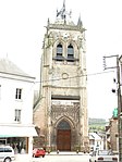
Aumale church

North side of the church
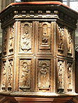
Sculpted wood panels on the pulpit

The Bresle river by the Moulin du Roy

The Bresle Viaduct, 755m long, constructed during 2002–2004 to carry the A29 motorway


| show Communes of the Seine-Maritime department |
|---|
| show Authority control |
|---|
- Communes of Seine-Maritime
- Dieppe geography stubs