Belleville-en-Caux
Belleville-en-Caux | |
|---|---|
 Coat of arms | |
show Location of Belleville-en-Caux | |
 Belleville-en-Caux | |
| Coordinates: 49°42′32″N 0°59′18″E / 49.7089°N 0.9883°ECoordinates: 49°42′32″N 0°59′18″E / 49.7089°N 0.9883°E | |
| Country | France |
| Region | Normandy |
| Department | Seine-Maritime |
| Arrondissement | Dieppe |
| Canton | Luneray |
| Intercommunality | CC Terroir de Caux |
| Government | |
| • Mayor (2020–2026) | Denis Guillebert[1] |
| Area 1 | 4.38 km2 (1.69 sq mi) |
| Population (Jan. 2018)[2] | 728 |
| • Density | 170/km2 (430/sq mi) |
| Time zone | UTC+01:00 (CET) |
| • Summer (DST) | UTC+02:00 (CEST) |
| INSEE/Postal code | 76072 /76890 |
| Elevation | 89–162 m (292–531 ft) (avg. 145 m or 476 ft) |
| 1 French Land Register data, which excludes lakes, ponds, glaciers > 1 km2 (0.386 sq mi or 247 acres) and river estuaries. | |


Belleville-en-Caux is a commune in the Seine-Maritime department in the Normandy region in northern France.
Geography[]
A village of farming and light industry situated by the banks of the river Saâne in the Pays de Caux, some 17 miles (27 km) south of Dieppe, at the junction of the D203 and the D25 roads.
Heraldry[]
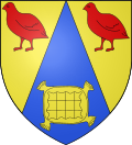 |
The arms of Belleville-en-Caux are blazoned : Azure chapé, a cushion Or, on each chapé a partridge gules.
|
Population[]
| Year | 1962 | 1968 | 1975 | 1982 | 1990 | 1999 | 2006 |
|---|---|---|---|---|---|---|---|
| Population | 185 | 210 | 261 | 305 | 330 | 357 | 516 |
| From the year 1962 on: No double counting—residents of multiple communes (e.g. students and military personnel) are counted only once. | |||||||
Places of interest[]
- The church of St. Wandrille, dating from the eleventh century.
See also[]
- Communes of the Seine-Maritime department
References[]
- ^ "Répertoire national des élus: les maires". data.gouv.fr, Plateforme ouverte des données publiques françaises (in French). 2 December 2020.
- ^ "Populations légales 2018". INSEE. 28 December 2020.
| Wikimedia Commons has media related to Belleville-en-Caux. |
| show Communes of the Seine-Maritime department |
|---|
Categories:
- Communes of Seine-Maritime
- Dieppe geography stubs