Bois-Himont
From Wikipedia, the free encyclopedia
Commune in Normandy, France
Bois-Himont | |
|---|---|
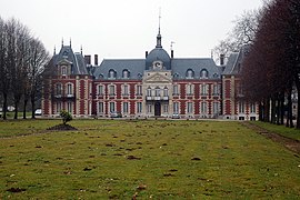 The chateau in Bois-Himont | |
 Coat of arms | |
 Bois-Himont  Bois-Himont | |
Coordinates:  49°35′08″N 0°42′10″E / 49.5856°N 0.7028°E / 49.5856; 0.7028Coordinates: 49°35′08″N 0°42′10″E / 49.5856°N 0.7028°E / 49.5856; 0.7028 49°35′08″N 0°42′10″E / 49.5856°N 0.7028°E / 49.5856; 0.7028Coordinates: 49°35′08″N 0°42′10″E / 49.5856°N 0.7028°E / 49.5856; 0.7028 | |
| Country | France |
| Region | Normandy |
| Department | Seine-Maritime |
| Arrondissement | Rouen |
| Canton | Yvetot |
| Government | |
| • Mayor (2020–2026) | Louis Eudier |
| Area 1 | 5.84 km2 (2.25 sq mi) |
| Population (Jan. 2018)[1] | 470 |
| • Density | 80/km2 (210/sq mi) |
| Time zone | UTC+01:00 (CET) |
| • Summer (DST) | UTC+02:00 (CEST) |
| INSEE/Postal code | 76110 /76190 |
| Elevation | 65–150 m (213–492 ft) (avg. 140 m or 460 ft) |
| 1 French Land Register data, which excludes lakes, ponds, glaciers > 1 km2 (0.386 sq mi or 247 acres) and river estuaries. | |

Bois-Himont is a commune in the Seine-Maritime department in the Normandy region in northern France.
Geography[]
A farming village situated in the Pays de Caux, some 28 miles (45 km) northwest of Rouen at the junction of the D104 and the D33 roads.
Population[]
| Year | 1962 | 1968 | 1975 | 1982 | 1990 | 1999 | 2006 |
|---|---|---|---|---|---|---|---|
| Population | 181 | 193 | 182 | 312 | 334 | 392 | 434 |
| From the year 1962 on: No double counting—residents of multiple communes (e.g. students and military personnel) are counted only once. | |||||||
Places of interest[]
- The church of St.Laurent, dating from the thirteenth century.
- A fifteenth-century chapel.
- The eighteenth-century chateau, nowadays a hotel and conference centre.
See also[]
- Communes of the Seine-Maritime department
References[]
- ^ "Populations légales 2018". INSEE. 28 December 2020.
External links[]
| Wikimedia Commons has media related to Bois-Himont. |
- The Chateau de Bois-Himont Archived 2011-10-05 at the Wayback Machine (in French)
show
Communes of the Seine-Maritime department | |
|---|---|
|
This Rouen geographical article is a stub. You can help Wikipedia by . |
- v
- t
Retrieved from ""
Categories:
- Communes of Seine-Maritime
- Rouen geography stubs
Hidden categories:
- Articles with short description
- Short description is different from Wikidata
- Infobox mapframe without OSM relation ID on Wikidata
- Coordinates on Wikidata
- Pages using infobox settlement with image map1 but not image map
- Commons category link is on Wikidata
- Webarchive template wayback links
- Articles with French-language sources (fr)
- Articles with BNF identifiers
- All stub articles
- Pages using the Kartographer extension