Brusque, Aveyron
show This article may be expanded with text translated from the corresponding article in French. (December 2008) Click [show] for important translation instructions. |
Brusque | |
|---|---|
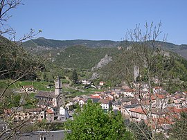 A general view of Brusque | |
 Coat of arms | |
show Location of Brusque | |
 Brusque | |
| Coordinates: 43°46′10″N 2°57′02″E / 43.7694°N 2.9506°ECoordinates: 43°46′10″N 2°57′02″E / 43.7694°N 2.9506°E | |
| Country | France |
| Region | Occitanie |
| Department | Aveyron |
| Arrondissement | Millau |
| Canton | Causses-Rougiers |
| Government | |
| • Mayor (2020–2026) | Hélène Ros-Chico |
| Area 1 | 36.18 km2 (13.97 sq mi) |
| Population (Jan. 2018)[1] | 268 |
| • Density | 7.4/km2 (19/sq mi) |
| Time zone | UTC+01:00 (CET) |
| • Summer (DST) | UTC+02:00 (CEST) |
| INSEE/Postal code | 12039 /12360 |
| Elevation | 416–1,080 m (1,365–3,543 ft) (avg. 452 m or 1,483 ft) |
| 1 French Land Register data, which excludes lakes, ponds, glaciers > 1 km2 (0.386 sq mi or 247 acres) and river estuaries. | |


Brusque (French pronunciation: [bʁysk]; Occitan: Brusca) is a commune in the Aveyron department in southern France.
Geography[]
The commune is traversed by the Dourdou de Camarès River.
Population[]
| Year | Pop. | ±% |
|---|---|---|
| 1962 | 545 | — |
| 1968 | 594 | +9.0% |
| 1975 | 540 | −9.1% |
| 1982 | 527 | −2.4% |
| 1990 | 422 | −19.9% |
| 1999 | 366 | −13.3% |
| 2008 | 314 | −14.2% |
See also[]
References[]
- ^ "Populations légales 2018". INSEE. 28 December 2020.
| Wikimedia Commons has media related to Brusque, Aveyron. |
| show Authority control |
|---|
This Aveyron geographical article is a stub. You can help Wikipedia by . |
Categories:
- Communes of Aveyron
- Aveyron geography stubs