Bures-en-Bray
Bures-en-Bray | |
|---|---|
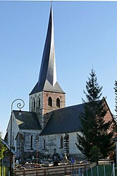 The church in Bures-en-Bray | |
show Location of Bures-en-Bray | |
 Bures-en-Bray | |
| Coordinates: 49°46′44″N 1°20′09″E / 49.7789°N 1.3358°ECoordinates: 49°46′44″N 1°20′09″E / 49.7789°N 1.3358°E | |
| Country | France |
| Region | Normandy |
| Department | Seine-Maritime |
| Arrondissement | Dieppe |
| Canton | Neufchâtel-en-Bray |
| Intercommunality | CC Londinières |
| Government | |
| • Mayor (2020–2026) | Jacky Lévêque |
| Area 1 | 10.99 km2 (4.24 sq mi) |
| Population (Jan. 2018)[1] | 325 |
| • Density | 30/km2 (77/sq mi) |
| Time zone | UTC+01:00 (CET) |
| • Summer (DST) | UTC+02:00 (CEST) |
| INSEE/Postal code | 76148 /76660 |
| Elevation | 47–201 m (154–659 ft) (avg. 83 m or 272 ft) |
| Website | www |
| 1 French Land Register data, which excludes lakes, ponds, glaciers > 1 km2 (0.386 sq mi or 247 acres) and river estuaries. | |


Bures-en-Bray (French pronunciation: [byʁ ɑ̃ bʁɛ], literally Bures in Bray) is a commune in the Seine-Maritime department in the Normandy region in northern France.
Geography[]
A farming village situated in the Pays de Bray, 20 miles (32 km) southeast of Dieppe, at the junction of the D1 with the D114 and D12 roads. The river Béthune flows through the middle of the village.
Population[]
| Year | 1962 | 1968 | 1975 | 1982 | 1990 | 1999 | 2006 |
|---|---|---|---|---|---|---|---|
| Population | 428 | 434 | 343 | 301 | 318 | 266 | 313 |
| From the year 1962 on: No double counting—residents of multiple communes (e.g. students and military personnel) are counted only once. | |||||||
Places of interest[]
- The church of St. Aignan, dating from the twelfth century.
- The sixteenth century manorhouse de Tourpes.
- The motte of a feudal castle from the twelfth century.[2]
See also[]
- Communes of the Seine-Maritime department
References[]
- ^ "Populations légales 2018". INSEE. 28 December 2020.
- ^ Decorde, Jean-Eugène (1872). "Histoire de Bures-en-Bray".
External links[]
| Wikimedia Commons has media related to Bures-en-Bray. |
- Bures-en-Bray sur le site de l'Institut géographique national (in French)
- Histoire de Bures-en-Bray par J.-E. DeCorde. (in French)
| show Communes of the Seine-Maritime department |
|---|
| show Authority control |
|---|
Categories:
- Communes of Seine-Maritime
- Dieppe geography stubs