Civray, Cher
This article does not cite any sources. (July 2016) |
Civray | |
|---|---|
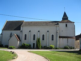 The church in Civray | |
 Coat of arms | |
show Location of Civray | |
 Civray | |
| Coordinates: 46°58′05″N 2°10′30″E / 46.9681°N 2.175°ECoordinates: 46°58′05″N 2°10′30″E / 46.9681°N 2.175°E | |
| Country | France |
| Region | Centre-Val de Loire |
| Department | Cher |
| Arrondissement | Bourges |
| Canton | Chârost |
| Intercommunality | Fercher - Pays florentais |
| Government | |
| • Mayor (2008–2014) | Serge Jeanzac |
| Area 1 | 40.87 km2 (15.78 sq mi) |
| Population (Jan. 2018)[1] | 913 |
| • Density | 22/km2 (58/sq mi) |
| Time zone | UTC+01:00 (CET) |
| • Summer (DST) | UTC+02:00 (CEST) |
| INSEE/Postal code | 18066 /18290 |
| Elevation | 125–162 m (410–531 ft) (avg. 155 m or 509 ft) |
| 1 French Land Register data, which excludes lakes, ponds, glaciers > 1 km2 (0.386 sq mi or 247 acres) and river estuaries. | |


Civray is a commune in the Cher department in the Centre-Val de Loire region of France.
Geography[]
A farming area comprising the village and several hamlets situated in the valley of the river Pontet some 15 miles (24 km) southwest of Bourges at the junction of the N151 with the D88, D184 and D84 roads.
Population[]
| Year | Pop. | ±% |
|---|---|---|
| 1962 | 832 | — |
| 1968 | 893 | +7.3% |
| 1975 | 840 | −5.9% |
| 1982 | 813 | −3.2% |
| 1990 | 1,023 | +25.8% |
| 1999 | 1,004 | −1.9% |
| 2008 | 994 | −1.0% |
Sights[]
- The church of St. Pierre, dating from the twelfth century.
- Traces of a medieval castle.
See also[]
- Communes of the Cher department
References[]
- ^ "Populations légales 2018". INSEE. 28 December 2020.
| Wikimedia Commons has media related to Civray (Cher). |
| show Communes of the Cher department |
|---|
| show Authority control |
|---|
Categories:
- Communes of Cher (department)