Culan
Culan | |
|---|---|
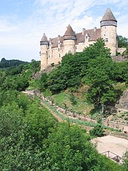 The Château de Culan | |
 Coat of arms | |
show Location of Culan | |
 Culan | |
| Coordinates: 46°32′54″N 2°21′00″E / 46.5483°N 2.35°ECoordinates: 46°32′54″N 2°21′00″E / 46.5483°N 2.35°E | |
| Country | France |
| Region | Centre-Val de Loire |
| Department | Cher |
| Arrondissement | Saint-Amand-Montrond |
| Canton | Châteaumeillant |
| Government | |
| • Mayor (2020–2026) | Nicolas Nauleau |
| Area 1 | 20.23 km2 (7.81 sq mi) |
| Population (Jan. 2018)[1] | 732 |
| • Density | 36/km2 (94/sq mi) |
| Time zone | UTC+01:00 (CET) |
| • Summer (DST) | UTC+02:00 (CEST) |
| INSEE/Postal code | 18083 /18270 |
| Elevation | 220–332 m (722–1,089 ft) (avg. 270 m or 890 ft) |
| 1 French Land Register data, which excludes lakes, ponds, glaciers > 1 km2 (0.386 sq mi or 247 acres) and river estuaries. | |


Culan is a commune in the Cher département in the Centre-Val de Loire region of France.
It is best known for its 12th-15th century medieval castle, the Château de Culan, one of the oldest castles still occupied in the world. The castle has beautiful medieval gardens and it is open to visitors every day from Easter until November.
Geography[]
The commune is a farming area comprising the village and a few hamlets situated by the banks of the Arnon river, in the south of the département some 35 miles (56 km) south of Bourges and at the junction of the D997 with the D943, D4 and D65 roads.
Population[]
| Year | Pop. | ±% |
|---|---|---|
| 1962 | 1,261 | — |
| 1968 | 1,310 | +3.9% |
| 1975 | 1,164 | −11.1% |
| 1982 | 1,055 | −9.4% |
| 1990 | 932 | −11.7% |
| 1999 | 822 | −11.8% |
| 2008 | 796 | −3.2% |
Sights[]
- The church of St. Vincent, dating from the seventeenth century
- The castle
- A watermill
- A nineteenth-century viaduct

The village of Culan
See also[]
- Château de Culan
- Communes of the Cher department
References[]
- ^ "Populations légales 2018". INSEE. 28 December 2020.
External links[]
| Wikimedia Commons has media related to Culan. |
- Website of the Château de Culan (in French)
| show Communes of the Cher department |
|---|
| show Authority control |
|---|
Categories:
- Communes of Cher (department)
- Berry, France