Denizli
Denizli | |
|---|---|
 View of the city from above | |
 Emblem of Denizli Metropolitan Municipality | |
 Denizli Location of Denizli | |
| Coordinates: 37°46′N 29°05′E / 37.767°N 29.083°ECoordinates: 37°46′N 29°05′E / 37.767°N 29.083°E | |
| Country | |
| Region | Aegean Region |
| Province | Denizli Province |
| Government | |
| • Mayor | Osman Zolan[3] (AKP) |
| Area | |
| • District | 798.75 km2 (308.40 sq mi) |
| Elevation | 324 m (1,063 ft) |
| Population (2012)[2] | |
| • Metropolitan municipality | 1.027.783 |
| • Urban | 646.278 |
| • District | 554,424 |
| • District density | 690/km2 (1,800/sq mi) |
| Time zone | UTC+3 (TRT) |
| Postal code | 20x xx |
| Area code(s) | (0090) 258 |
| Licence plate | 20 |
| Website | [4] |


Denizli, Ancient Greek: (Αττούδα) is an industrial city in the southwestern part of Turkey and the eastern end of the alluvial valley formed by the river Büyük Menderes, where the plain reaches an elevation of about three hundred and fifty metres (1,148 ft). Denizli is located in the country's Aegean Region.
The city has a population of about 646,278 (2018 census). This is a jump from 389,000 in 2007, due to the merger of 13 municipalities and 10 villages when the area under Denizli Municipality jurisdiction increased almost fivefold and the population around 50 percent. Denizli (Municipality) is the capital city of Denizli Province.
Denizli has seen economic development in the last few decades, mostly due to textile production and exports.[5][6]
Denizli also attracts visitors to the nearby mineral-coated hillside hot spring of Pamukkale, and with red color thermal water spa hotels , just 5 kilometres (3 miles) north of Pamukkale. Recently, Denizli became a major domestic tourism destination due to the various types of thermal waters in Sarayköy, Central/Denizli (where Karahayıt and Pamukkale towns are located), Akköy (Gölemezli), Buldan (Yenicekent), and Çardak districts.
The ancient ruined city of Hierapolis, as well as ruins of the city of Laodicea on the Lycus, the ancient metropolis of Phrygia. Also in the depending of Honaz, about 10 mi (16 km) west of Denizli is, what was, in the 1st century AD, the city of Colossae.
The weather is hot in Denizli in summers, whereas in winters, it may occasionally be very cold with snow on the mountains that surround the city. Some years, snow can be observed in the urban areas. Springs and autumns are rainy, mild climate, warm.
History[]


In antiquity, it was an important Greek town, called Attouda (Αττούδα), that existed through the ancient Greek and Roman eras; it was near the cities (Hierapolis and Laodicea on the Lycus) and flourished through the Byzantine period.
The city was conquered by the Turks. The inhabitants of Laodicea were also resettled here in the Seljuk period.[7]
Ibn Battuta visited the city, noting that "In it there are seven mosques for the observance of Friday prayers, and it has splendid gardens, perennial streams, and gushing springs. Most of the artisans there are Greek women, for in it are many Greeks who are subject to the Muslims and who pay dues to the sultan, including the jizyah, and other taxes."[8]
In the 17th century, the Turkish traveler Evliya Çelebi visited Denizli and recorded the town as follows: "The city is called by Turks as (Denizli) (which means has abundant of water sources like sea in Turkish) as there are several rivers and lakes around it. In fact it is a four-day trip from the sea. Its fortress is of square shape built on flat ground. It has no ditches. Its periphery is 470 steps long. It has four gates. These are: painters gate in North, saddle-makers gate in the East, new Mosque gate in the South, and vineyard gate in the West. There are some fifty armed watchmen in the fortress, and they attend the shop. The main city is outside the fortress with 44 districts and 3600 houses. There are 57 small and large mosques and district masjids, 7 madrasahs, 7 children's schools, 6 baths and 17 dervish lodges. As everybody lives in vineyards the upper classes and ordinary people do not flee from each other."[citation needed]
The city lived in peace for centuries without being involved in wars in a direct manner. Following World War I during the Independence War, the Greek forces managed to come as close as Sarayköy, a small town 20 km (12 mi) northwest of Denizli, but did not venture into Denizli. The most widespread symbols of Denizli province are of textile industry.[citation needed]
Climate[]
Denizli has a Mediterranean climate (Köppen: Csa or Trewartha: Cs), with hot, dry summers and mild to cool, rainy winters. The inland areas, like Çardak, Bozkurt, Çivril, and Çal districts/counties of the province are cooler and have a higher elevation than the seaside, western part of the Province. Therefore, there are climatic differences within the province and even in the Denizli urbanized area.[citation needed] The land is open to winds coming from the Aegean Sea as the mountains are perpendicular to the coastline.
| hideClimate data for Denizli (1991–2020, extremes 1957–2020) | |||||||||||||
|---|---|---|---|---|---|---|---|---|---|---|---|---|---|
| Month | Jan | Feb | Mar | Apr | May | Jun | Jul | Aug | Sep | Oct | Nov | Dec | Year |
| Record high °C (°F) | 22.6 (72.7) |
25.9 (78.6) |
30.8 (87.4) |
35.8 (96.4) |
39.5 (103.1) |
44.1 (111.4) |
43.9 (111.0) |
44.4 (111.9) |
41.6 (106.9) |
36.9 (98.4) |
29.9 (85.8) |
26.6 (79.9) |
44.4 (111.9) |
| Average high °C (°F) | 10.7 (51.3) |
12.7 (54.9) |
16.5 (61.7) |
21.3 (70.3) |
27.0 (80.6) |
32.3 (90.1) |
35.7 (96.3) |
35.7 (96.3) |
31.0 (87.8) |
24.7 (76.5) |
17.8 (64.0) |
12.2 (54.0) |
23.1 (73.6) |
| Daily mean °C (°F) | 6.2 (43.2) |
7.6 (45.7) |
10.7 (51.3) |
15.1 (59.2) |
20.2 (68.4) |
25.1 (77.2) |
28.3 (82.9) |
28.2 (82.8) |
23.5 (74.3) |
17.9 (64.2) |
11.9 (53.4) |
7.7 (45.9) |
16.9 (62.4) |
| Average low °C (°F) | 2.7 (36.9) |
3.6 (38.5) |
6.0 (42.8) |
9.7 (49.5) |
14.2 (57.6) |
18.6 (65.5) |
21.6 (70.9) |
21.5 (70.7) |
17.2 (63.0) |
12.5 (54.5) |
7.5 (45.5) |
4.4 (39.9) |
11.6 (52.9) |
| Record low °C (°F) | −10.5 (13.1) |
−11.4 (11.5) |
−7.0 (19.4) |
−2.0 (28.4) |
2.7 (36.9) |
7.9 (46.2) |
12.6 (54.7) |
11.6 (52.9) |
6.6 (43.9) |
−0.8 (30.6) |
−4.5 (23.9) |
−10.4 (13.3) |
−11.4 (11.5) |
| Average precipitation mm (inches) | 85.7 (3.37) |
69.7 (2.74) |
63.8 (2.51) |
54.8 (2.16) |
47.9 (1.89) |
31.8 (1.25) |
16.3 (0.64) |
12.1 (0.48) |
15.7 (0.62) |
37.1 (1.46) |
57.8 (2.28) |
81.1 (3.19) |
573.8 (22.59) |
| Average precipitation days | 11.70 | 10.93 | 11.23 | 10.07 | 9.67 | 5.77 | 2.93 | 2.83 | 3.57 | 6.70 | 7.67 | 12.17 | 95.2 |
| Mean monthly sunshine hours | 111.6 | 130.0 | 173.6 | 207.0 | 272.8 | 321.0 | 359.6 | 325.5 | 264.0 | 207.7 | 147.0 | 102.3 | 2,622.1 |
| Mean daily sunshine hours | 3.6 | 4.6 | 5.6 | 6.9 | 8.8 | 10.7 | 11.6 | 10.5 | 8.8 | 6.7 | 4.9 | 3.3 | 7.2 |
| Source: Turkish State Meteorological Service[9] | |||||||||||||
Denizli today[]
Economy[]


During World War I, Denizli mined chromium.[10]
Transportation[]
Denizli Çardak Airport is about 45 minutes drive from the city center.
The extension of İzmir-Aydın highway to Denizli has been announced for several years. Initial infrastructure was laid in Aydın, but the rest is still forthcoming. The present Aydın-Denizli road, has a very high level of traffic, especially trucks, with each town along the road possessing its own industrial zone.
Places of interest[]
- Laodicea ad Lycum - 6 km (4 mi) north of Denizli near the village of Eskihisar. The city was established by Seleucid King, Antiochus II in honor of his wife, Laodice. This trading city was famous for its woolen and cotton cloths. A letter written by a Laodecian says: "I am happy. I have fortune and I am not in need of anything." Following a large earthquake which destroyed the city, what remains of the ancient city are one of the seven churches of Asia Minor, the stadium, the amphitheatre and the odeon, the cistern and the aqueduct. (see further Laodicean Church)
- Hierapolis and Pamukkale World Heritage Sites -20 km (12 mi) north of Denizli Pamukkale traventines. The city of Hierapolis was founded by the Pergamon King Eumenes II in 190 BC. Its closeness to Laodicea led to commercial and military rivalry. The town was built in Greek style. Despite suffering a violent earthquake in 17 AD, it reached its peak during the Roman and Byzantine periods. It was reconstructed during the 2nd and 3rd centuries in stone from quarries in the area, in a Roman style. The town had its most glorious years during the reign of Roman Emperors Septimius Severus and Caracalla and became an episcopal seat during the expansion of Christianity. However, as a result of several earthquakes, the most violent of which was in 1354, a great part of the town was destroyed, and its people migrated.
- The Seljuq caravanserai Akhan, which is 6 km (4 mi) from Denizli City on the Ankara highway, and a great part of which still remains, was constructed by Karasungur bin Abdullah in 1253-54 when he was acting as the commander of Ladik. It was recently restored along with the Ottoman konaks nearby and is set to become a visitor's attraction by its own right.
- Honaz mountain is a popular picnic excursion for Denizli's people in summer.
- The nearby village of Goncalı, which is on the railway line, is another excursion. People come to eat the charcoal-grilled thinly-cut kebab called çöp şiş, preferably with the local süzme yoghurt and a glass of rakı.
- There is a statue of Atatürk at Çınar Meydanı in the city centre.
- is located close to the Yenişehir neighborhood. The tomb of the 12th century Turkish commander of the Seljuk akıncı unit is located there. Many locals enjoy visiting and making prayers at the tomb especially on weekends.
- , Teraspark AVM, located in Yenişehir. Teraspark AVM is the biggest shopping center in Denizli.
- , Forum Çamlık AVM, located in the heart of the city centre, Demokrasi Meydanı/Square and surrounded by residential areas, welcomes more than 450,000 people within a catchment area of 20 minutes. The design of Forum Çamlık was inspired by the rich architectural elements that are unique to Province of Denizli. Local stones like Denizli travertine and marble are used for the cladding of many buildings. The visitors will enjoy a detailed artwork, small ponds, squares and rich landscaping features. Given its wide range of shop mix and entertainment facilities, including theaters/cinemas, the centre became a very important destination for visitors in Denizli and neighbouring cities.
Sport[]
Merkezefendi Belediyesi Denizli Basket represents Merkezefendi and Denizli in Turkish Basketball Super League (BSL).
Denizlispor is the football team that represents Denizli in the Turkish First League.
Administration[]


List of districts and 2016 census. [11]
| District | Population (2016) |
|---|---|
| Merkezefendi | 287,852 |
| Pamukkale | 337,444 |
| Acıpayam | 55,279 |
| Babadağ | 6,498 |
| Baklan | 5,632 |
| Bekilli | 7,045 |
| Beyağaç | 6,611 |
| Bozkurt | 12,715 |
| Buldan | 27,335 |
| Çal | 19,431 |
| Çameli | 18,238 |
| Çardak | 8,798 |
| Çivril | 60,721 |
| Güney | 10,197 |
| Honaz | 32,136 |
| Kale | 20,465 |
| Sarayköy | 30,173 |
| Serinhisar | 14,600 |
| Tavas | 44,517 |
| Grand total | 1,005,687 |
Notable people[]
- Veli Acar, Football player
- Sezen Aksu, Pop singer
- Ugur Aktas, Football player
- Cengiz Bektaş, Architect and writer
- Sıla Gençoğlu, Pop singer
- Hasan Güngör, Olympic medalist in wrestling
- Aysel Gürel, Turkish songwriter and theater actress.
- Levent Kartop, Football player
- Recep Niyaz, Football player
- Yavuz Özkan, Football player
- Sarp Sanin, Rock singer
- Osman Sınav, producer, director, screenwriter, and the advertiser is.
- Bayram Şit, Olympic medalist in wrestling
- Hasan Ali Toptaş, Author
- Kemal Türkler, Trade union leader and politician
- Tuba Ünsal, Turkish actress and model
- , Board Certified Pathologist
- , Surgeon
- , Doctor
- Kerem Yılmazer, Turkish theater and movie actor, voice actor
- , burada yaşayan birisi.
Ancient sites of Denizli[]
International relations[]
Twin towns — sister cities[]
Denizli is twinned with:
|
See also[]
References[]
- ^ "Area of regions (including lakes), km²". Regional Statistics Database. Turkish Statistical Institute. 2002. Retrieved 2013-03-05.
- ^ "Turkey: Major cities and provinces". citypopulation.de. Retrieved 2015-02-08.
- ^ https://www.denizli.bel.tr/Default.aspx?k=biyografi
- ^ "Denizli, Turkey - Denizli - Woonplaats, Maatschappij en overheid". Facebook. Retrieved 2013-09-01.
- ^ Bernard Fingleton; Ayda Eraydın; Raffaele Paci; Bilge Armatlı Köroğlu; Burak Beyhan (2003). Regional Economic Growth, SMEs and the Wider Europe, Chapter 11: The changing role of SMEs in the regional growth process: The case of Denizli. Ashgate Publishing. p. 229. ISBN 0-7546-3613-5.
- ^ Hüseyin Özgür, Pamukkale University. "Integration of a Local Economy to the Global and European Markets through Export–Led Growth and Specialized Textile Products Export: Home Textile Production in Denizli – Turkey" (PDF). University of Lodz. Archived from the original (PDF) on 2007-06-30. Retrieved 2007-04-18.
- ^ John Freely, The western shores of Turkey: discovering the Aegean and Mediterranean coasts, 2004. ISBN 1-85043-618-5. p. 182.
- ^ Battutah, Ibn (2002). The Travels of Ibn Battutah. London: Picador. pp. 105, 309. ISBN 9780330418799.
- ^ "Resmi İstatistikler: İllerimize Ait Mevism Normalleri (1991–2020)" (in Turkish). Turkish State Meteorological Service. Retrieved 1 May 2021.
- ^ Prothero, G.W. (1920). Anatolia. London: H.M. Stationery Office. p. 104.
- ^ "2016 Yılı Adrese Dayalı Nüfus Kayıt Sistemi Sonuçları" (PDF). . Retrieved 2017-09-10.
- ^ "Kardeş Şehirler". Bursa Büyükşehir Belediyesi Basın Koordinasyon Merkez. Tüm Hakları Saklıdır. Retrieved 2013-07-27.
External links[]
| Wikimedia Commons has media related to Denizli. |
 Denizli travel guide from Wikivoyage
| show Denizli in Denizli Province of Turkey |
|---|

| Rank | Name | Province | Pop. | Rank | Name | Province | Pop. | ||
|---|---|---|---|---|---|---|---|---|---|
 Istanbul 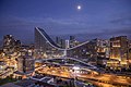 Ankara |
1 | Istanbul | Istanbul | 14,744,519 | 11 | Mersin | Mersin | 1,005,455 |  İzmir  Bursa |
| 2 | Ankara | Ankara | 4,871,884 | 12 | Urfa | Şanlıurfa | 921,978 | ||
| 3 | İzmir | İzmir | 2,938,546 | 13 | Eskişehir | Eskişehir | 752,630 | ||
| 4 | Bursa | Bursa | 2,074,799 | 14 | Denizli | Denizli | 638,989 | ||
| 5 | Adana | Adana | 1,753,337 | 15 | Kahramanmaraş | Kahramanmaraş | 632,487 | ||
| 6 | Gaziantep | Gaziantep | 1,663,273 | 16 | Samsun | Samsun | 625,410 | ||
| 7 | Antalya | Antalya | 1,311,471 | 17 | Malatya | Malatya | 618,831 | ||
| 8 | Konya | Konya | 1,130,222 | 18 | İzmit | Kocaeli | 570,077 | ||
| 9 | Kayseri | Kayseri | 1,123,611 | 19 | Adapazarı | Sakarya | 492,027 | ||
| 10 | Diyarbakır | Diyarbakır | 1,047,286 | 20 | Erzurum | Erzurum | 422,389 | ||
| Authority control |
|---|
- Denizli
- Cities in Turkey
- Districts of Denizli Province
- Populated places in Denizli Province