Gonfreville-Caillot
Gonfreville-Caillot | |
|---|---|
 The church in Gonfreville-Caillot | |
 Coat of arms | |
show Location of Gonfreville-Caillot | |
 Gonfreville-Caillot | |
| Coordinates: 49°39′10″N 0°26′29″E / 49.6528°N 0.4414°ECoordinates: 49°39′10″N 0°26′29″E / 49.6528°N 0.4414°E | |
| Country | France |
| Region | Normandy |
| Department | Seine-Maritime |
| Arrondissement | Le Havre |
| Canton | Saint-Romain-de-Colbosc |
| Intercommunality | CC Campagne de Caux |
| Government | |
| • Mayor (2020–2026) | Christian Leroux |
| Area 1 | 4.22 km2 (1.63 sq mi) |
| Population (Jan. 2018)[1] | 361 |
| • Density | 86/km2 (220/sq mi) |
| Time zone | UTC+01:00 (CET) |
| • Summer (DST) | UTC+02:00 (CEST) |
| INSEE/Postal code | 76304 /76110 |
| Elevation | 112–134 m (367–440 ft) (avg. 129 m or 423 ft) |
| 1 French Land Register data, which excludes lakes, ponds, glaciers > 1 km2 (0.386 sq mi or 247 acres) and river estuaries. | |


Gonfreville-Caillot is a commune in the Seine-Maritime department in the Normandy region in northern France.
Geography[]
A small farming village situated in the Pays de Caux, some 19 miles (31 km) northeast of Le Havre, at the junction of the D452 and D75 roads.
Heraldry[]
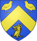 |
The arms of Gonfreville-Caillot are blazoned : Azure, a chevron between 2 quail respectant and a griffon's head erased Or.
|
Population[]
| Year | 1962 | 1968 | 1975 | 1982 | 1990 | 1999 | 2006 |
|---|---|---|---|---|---|---|---|
| Population | 132 | 157 | 124 | 215 | 251 | 262 | 309 |
| From the year 1962 on: No double counting—residents of multiple communes (e.g. students and military personnel) are counted only once. | |||||||
Places of interest[]
- The church of St.Maur, dating from the seventeenth century.
- The remains of a feudal motte.
See also[]
- Communes of the Seine-Maritime department
References[]
- ^ "Populations légales 2018". INSEE. 28 December 2020.
| Wikimedia Commons has media related to Gonfreville-Caillot. |
| show Communes of the Seine-Maritime department |
|---|
Categories:
- Communes of Seine-Maritime
- Le Havre geography stubs