Longeaux
From Wikipedia, the free encyclopedia
Commune in Grand Est, France
Longeaux | |
|---|---|
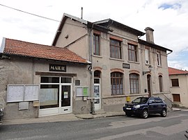 The town hall in Longeaux | |
 Coat of arms | |
 Longeaux  Longeaux | |
Coordinates:  48°38′51″N 5°20′28″E / 48.6475°N 5.3411°E / 48.6475; 5.3411Coordinates: 48°38′51″N 5°20′28″E / 48.6475°N 5.3411°E / 48.6475; 5.3411 48°38′51″N 5°20′28″E / 48.6475°N 5.3411°E / 48.6475; 5.3411Coordinates: 48°38′51″N 5°20′28″E / 48.6475°N 5.3411°E / 48.6475; 5.3411 | |
| Country | France |
| Region | Grand Est |
| Department | Meuse |
| Arrondissement | Bar-le-Duc |
| Canton | Ligny-en-Barrois |
| Intercommunality | |
| Government | |
| • Mayor (2008–2014) | Jackie Fonroques |
| Area 1 | 7.49 km2 (2.89 sq mi) |
| Population (Jan. 2018)[1] | 225 |
| • Density | 30/km2 (78/sq mi) |
| Time zone | UTC+01:00 (CET) |
| • Summer (DST) | UTC+02:00 (CEST) |
| INSEE/Postal code | 55300 /55500 |
| Elevation | 228–347 m (748–1,138 ft) (avg. 240 m or 790 ft) |
| 1 French Land Register data, which excludes lakes, ponds, glaciers > 1 km2 (0.386 sq mi or 247 acres) and river estuaries. | |

Longeaux is a commune in the Meuse department in Grand Est in north-eastern France.
See also[]
References[]
- ^ "Populations légales 2018". INSEE. 28 December 2020.
| Wikimedia Commons has media related to Longeaux. |
This Meuse geographical article is a stub. You can help Wikipedia by . |
- v
- t
Retrieved from ""
Categories:
- Communes of Meuse (department)
- Meuse (department) geography stubs
Hidden categories:
- Articles with short description
- Short description is different from Wikidata
- Infobox mapframe without OSM relation ID on Wikidata
- Coordinates on Wikidata
- Pages using infobox settlement with image map1 but not image map
- Commons category link from Wikidata
- Articles with BNF identifiers
- All stub articles
- Pages using the Kartographer extension