Louppy-le-Château
Louppy-le-Château | |
|---|---|
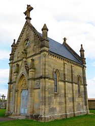 The cemetery chapel in Louppy-le-Château | |
 Coat of arms | |
show Location of Louppy-le-Château | |
 Louppy-le-Château | |
| Coordinates: 48°52′04″N 5°04′37″E / 48.8678°N 5.0769°ECoordinates: 48°52′04″N 5°04′37″E / 48.8678°N 5.0769°E | |
| Country | France |
| Region | Grand Est |
| Department | Meuse |
| Arrondissement | Bar-le-Duc |
| Canton | Revigny-sur-Ornain |
| Intercommunality | CC de l'Aire à l'Argonne |
| Government | |
| • Mayor (2008–2014) | Émile Thouvenin |
| Area 1 | 18.76 km2 (7.24 sq mi) |
| Population (Jan. 2018)[1] | 158 |
| • Density | 8.4/km2 (22/sq mi) |
| Time zone | UTC+01:00 (CET) |
| • Summer (DST) | UTC+02:00 (CEST) |
| INSEE/Postal code | 55304 /55800 |
| Elevation | 163–232 m (535–761 ft) (avg. 196 m or 643 ft) |
| 1 French Land Register data, which excludes lakes, ponds, glaciers > 1 km2 (0.386 sq mi or 247 acres) and river estuaries. | |


Louppy-le-Château is a commune in the Meuse department in Grand Est in north-eastern France.
Geography[]
The village lies in the middle of the commune, on the left bank of The Chée, which flows northwestward through the middle of the commune.
See also[]
References[]
- ^ "Populations légales 2018". INSEE. 28 December 2020.
| Wikimedia Commons has media related to Louppy-le-Château. |
This Meuse geographical article is a stub. You can help Wikipedia by . |
Categories:
- Communes of Meuse (department)
- Meuse (department) geography stubs