Meraux, Louisiana
Meraux | |
|---|---|
Census-designated place | |
 Location in St. Bernard Parish and the state of Louisiana. | |
| Coordinates: 29°55′39″N 89°55′07″W / 29.92750°N 89.91861°WCoordinates: 29°55′39″N 89°55′07″W / 29.92750°N 89.91861°W | |
| Country | United States |
| State | Louisiana |
| Parish | St. Bernard |
| Area | |
| • Total | 4.8 sq mi (12 km2) |
| • Land | 4.2 sq mi (11 km2) |
| • Water | 0.6 sq mi (2 km2) |
| Elevation | 7 ft (2 m) |
| Population (2000) | |
| • Total | 10,192 |
| • Density | 2,100/sq mi (820/km2) |
| Time zone | UTC-6 (CST) |
| • Summer (DST) | UTC-5 (CDT) |
| Area code(s) | 504 |

Meraux is a census-designated place (CDP) in St. Bernard Parish, Louisiana, United States. The population was 10,192 at the 2000 census. It is part of the New Orleans–Metairie–Kenner Metropolitan Statistical Area.
History[]
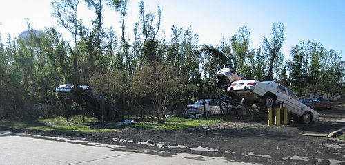
In 2005, the town was devastated by storm surge and wind associated with Hurricane Katrina which destroyed the Mississippi River-Gulf Outlet Canal (MRGO) levee.
Geography[]
Meraux is located at 29°55′39″N 89°55′7″W / 29.92750°N 89.91861°W (29.927561, -89.918508).[1] According to the United States Census Bureau, the CDP has a total area of 4.8 square miles (12.4 km2), of which 4.2 square miles (10.8 km2) is land and 0.6 square mile (1.6 km2) (12.94%) is water.
Demographics[]
2020 census[]
| Race | Number | Percentage |
|---|---|---|
| White (non-Hispanic) | 4,427 | 65.06% |
| Black or African American (non-Hispanic) | 1,005 | 14.77% |
| Native American | 40 | 0.59% |
| Asian | 152 | 2.23% |
| Other/Mixed | 308 | 4.53% |
| Hispanic or Latino | 872 | 12.82% |
As of the 2020 United States census, there were 6,804 people, 2,184 households, and 1,632 families residing in the CDP.
2000 census[]
As of the census[3] of 2000, there were 10,192 people, 3,707 households, and 2,772 families residing in the CDP. The population density was 2,447.8 people per square mile (946.0/km2). There were 3,793 housing units at an average density of 911.0 per square mile (352.0/km2). The racial makeup of the CDP was 92.71% White, 3.66% African American, 0.47% Native American, 1.63% Asian, 0.33% from other races, and 1.20% from two or more races. Hispanic or Latino of any race were 4.07% of the population.
There were 3,707 households, out of which 38.8% had children under the age of 18 living with them, 59.6% were married couples living together, 11.5% had a female householder with no husband present, and 25.2% were non-families. 21.8% of all households were made up of individuals, and 10.8% had someone living alone who was 65 years of age or older. The average household size was 2.75 and the average family size was 3.23.
In the CDP, the population was spread out, with 27.4% under the age of 18, 8.7% from 18 to 24, 31.7% from 25 to 44, 22.5% from 45 to 64, and 9.7% who were 65 years of age or older. The median age was 35 years. For every 100 females, there were 91.1 males. For every 100 females age 18 and over, there were 87.6 males.
The median income for a household in the CDP was $45,732, and the median income for a family was $52,408. Males had a median income of $38,727 versus $24,004 for females. The per capita income for the CDP was $17,951. About 6.4% of families and 9.1% of the population were below the poverty line, including 7.8% of those under age 18 and 11.3% of those age 65 or over.
Education[]
Residents are zoned to schools in the St. Bernard Parish Public Schools.
As of 2007, Chalmette High School serves the population.
References[]
- ^ "US Gazetteer files: 2010, 2000, and 1990". United States Census Bureau. 2011-02-12. Retrieved 2011-04-23.
- ^ "Explore Census Data". data.census.gov. Retrieved 2021-12-28.
- ^ "U.S. Census website". United States Census Bureau. Retrieved 2008-01-31.
External links[]
| Wikimedia Commons has media related to Meraux, Louisiana. |
Municipalities and communities of St. Bernard Parish, Louisiana, United States | ||
|---|---|---|
Parish seat: Chalmette | ||
| CDPs | 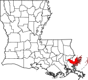 | |
| Other communities | ||
| Ghost towns | ||
| ||

- Census-designated places in St. Bernard Parish, Louisiana
- Census-designated places in Louisiana
- Census-designated places in New Orleans metropolitan area
- Louisiana populated places on the Mississippi River