Evangeline Parish, Louisiana
This article needs additional citations for verification. (May 2008) |
Evangeline Parish | |
|---|---|
Parish | |
| Parish of Evangeline | |
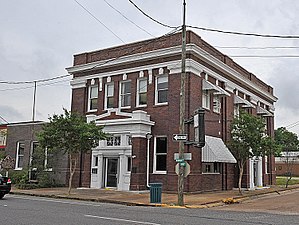 Evangeline Bank and Trust Co. Building, Ville Platte, Louisiana | |
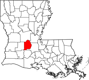 Location within the U.S. state of Louisiana | |
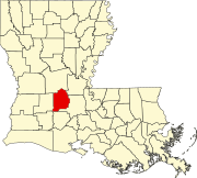
 Louisiana's location within the U.S. | |
| Coordinates: 30°44′N 92°25′W / 30.73°N 92.41°W | |
| Country | |
| State | |
| Founded | 1910 |
| Named for | Acadian heroine of the poem "Evangeline" |
| Seat | Ville Platte |
| Largest city | Ville Platte |
| Area | |
| • Total | 680 sq mi (1,800 km2) |
| • Land | 662 sq mi (1,710 km2) |
| • Water | 17 sq mi (40 km2) 2.5% |
| Population (2010) | |
| • Total | 33,984 |
| • Estimate (2018) | 33,443 |
| • Density | 50/sq mi (19/km2) |
| Time zone | UTC−6 (Central) |
| • Summer (DST) | UTC−5 (CDT) |
| Congressional district | 5th |

Evangeline Parish (French: Paroisse d'Évangéline) is a parish located in the U.S. state of Louisiana. As of the 2010 census, the population was 33,984.[1] The parish seat is Ville Platte.[2]
History[]
The parish was created out of lands formerly belonging to St. Landry Parish in 1910.[3] The majority of the area was originally settled by French Canadian colonists and former colonial marines (coureurs de bois) from such outposts as Fort Toulouse and Fort Kaskaskia and later included 19th-century French-speaking soldiers and immigrant families.
The early generations were born in colonial French colonies, which included the enormous Louisiana territory ('Upper and Lower' Louisiana) known as "la Nouvelle France", and later were born under Spanish rule.
Many people of Evangeline are primarily of French, English, and Spanish descent from Louisiana's colonial period. Examples of the French family names are Fontenot, Brignac, Ardoin, Bordelon, Vidrine, Courville, Gaspard, LaFleur, Chataignier, Dupre, Berza, Manuel, Ratelle, Fuselier, Landreneau, Andrepont, Guillory, Soileau, LeBas, and Gobert, among others. People of Spanish Canary Islands heritage (Isleños) can be observed to have settled in the Parish as well, bringing names like Aguillard, Casaneuva, De Soto, Ortego, Rozas, and Segura. Many English Americans as colonists came from the Eastern United States to settle in the newly purchased Louisiana Territory often married into Acadian families. Some prominent English surnames include Chapman, Kershaw, Young, Reed, Langley, Tate and Buller.
A few Acadians such as François Pitre and his wife settled the area between Evangeline and St. Landry parishes, preferring the rich pre-American and pre-Civil War era Cajun planter's lifestyle over that of the humble and isolated existence of their Acadiana cousins.
The parish was named Evangeline in honor of Henry Wadsworth Longfellow's narrative poem, Evangeline. It was from this poem that founding father Paulin Fontenot was to propose the namesake of "Evangeline" for this parish, allegedly foreseeing an emerging American tourism centered upon the Acadian saga. (See Ville Platte Gazette, Sept. 2010) In 19th-century American literature, she would gain popularity through Hollywood's interest, and thus began the embryonic 'Acadian-based' tourism which sprang up in St. Martinville. Evangeline Parish is mentioned in the Randy Newman song "Louisiana 1927", in which he described the Great Mississippi Flood which covered it with six feet of water.
Ville Platte, Louisiana, the seat of Evangeline Parish, was itself so named by one of Napoleon Bonaparte's former soldiers, Adjutant Major Marcellin Garand (1781-1852), of Savoy, France. (See Napoleon's Soldiers In America, by Simone de la Souchere-Delery, 1999).
Geography[]
According to the U.S. Census Bureau, the parish has a total area of 680 square miles (1,800 km2), of which 662 square miles (1,710 km2) is land and 17 square miles (44 km2) (2.5%) is water.[4]
Major highways[]
 Interstate 49
 U.S. Highway 190
 U.S. Highway 167
 Louisiana Highway 10
 Louisiana Highway 13
 Louisiana Highway 29
Adjacent parishes[]
- Rapides Parish (north)
- Avoyelles Parish (northeast)
- St. Landry Parish (east)
- Acadia Parish (south)
- Allen Parish (west)
National protected area[]
State parks[]
Demographics[]
| Historical population | |||
|---|---|---|---|
| Census | Pop. | %± | |
| 1920 | 23,485 | — | |
| 1930 | 25,483 | 8.5% | |
| 1940 | 30,497 | 19.7% | |
| 1950 | 31,629 | 3.7% | |
| 1960 | 31,639 | 0.0% | |
| 1970 | 31,932 | 0.9% | |
| 1980 | 33,343 | 4.4% | |
| 1990 | 33,274 | −0.2% | |
| 2000 | 35,434 | 6.5% | |
| 2010 | 33,984 | −4.1% | |
| 2018 (est.) | 33,443 | [5] | −1.6% |
| U.S. Decennial Census[6] 1790-1960[7] 1900-1990[8] 1990-2000[9] 2010-2013[1] | |||
As of the 2010 United States Census, there were 33,984 people living in the parish. 69.0% were White, 28.3% Black or African American, 0.3% Asian, 0.3% Native American, 1.0% of some other race and 1.1% of two or more races. 2.3% were Hispanic or Latino (of any race). 40.0% were of French, French Canadian or Cajun ancestry and 9.1% identified as having American ancestry.[10]
As of the census[11] of 2000, there were 35,434 people, 12,736 households, and 9,157 families living in the parish. The population density was 53 people per square mile (21/km2). There were 14,258 housing units at an average density of 22 per square mile (8/km2). The racial makeup of the parish was 70.42% White, 28.57% Black or African American, 0.23% Native American, 0.14% Asian, 0.01% Pacific Islander, 0.18% from other races, and 0.46% from two or more races. 1.04% of the population were Hispanic or Latino of any race. 25.71% reported speaking French or Cajun French at home, the highest percentage of any Louisiana parish.[12]
There were 12,736 households, out of which 38.00% had children under the age of 18 living with them, 52.30% were married couples living together, 15.50% had a female householder with no husband present, and 28.10% were non-families. 25.80% of all households were made up of individuals, and 11.90% had someone living alone who was 65 years of age or older. The average household size was 2.64 and the average family size was 3.19.
In the parish the population was spread out, with 29.60% under the age of 18, 9.60% from 18 to 24, 27.60% from 25 to 44, 20.40% from 45 to 64, and 12.80% who were 65 years of age or older. The median age was 34 years. For every 100 females there were 99.40 males. For every 100 females age 18 and over, there were 98.10 males.
The median income for a household in the parish was $20,532, and the median income for a family was $27,243. Males had a median income of $30,386 versus $16,793 for females. The per capita income for the parish was $11,432. About 27.20% of families and 32.20% of the population were below the poverty line, including 39.10% of those under age 18 and 31.00% of those age 65 or over.
Education[]
Public Schools in Evangeline Parish are operated by the Evangeline Parish School Board.
- Bayou Chicot Elementary School (Grades PK-8) (Ville Platte)
- Chataignier Elementary School (Grades PK-8) (Chataignier)
- James Stephens Montessori School (Grades PK-6) (Ville Platte)
- Mamou Elementary School (Grades PK-4) (Mamou)
- Vidrine Elementary School (Grades PK-8) (Ville Platte)
- Ville Platte Elementary School (Grades PK-4) (Ville Platte)
- W. W. Stewart Elementary (Grades PK-4) (Basile)
- Basile High School (Grades 5-12) (Basile)
- Mamou High School (Grades 5-12) (Mamou)
- Pine Prairie High School (Grades 9-12) (Pine Prairie)
- Ville Platte High School (Grades 5-12) (Ville Platte)
- Evangeline Central School (Grades 4-12) (Ville Platte)
Evangeline Parish is also served by the Diocese of Lafayette with one school:
- Sacred Heart School (Grades K-12) (Ville Platte)
Additionally, Evangeline Parish is served by one unaffiliated private school:
- Christian Heritage Academy (Grade K) (Ville Platte)
Evangeline Parish is served by one institutions of higher education:
- South Louisiana Community College service area,[13] C. B. Coreil Campus (Ville Platte
Communities[]

City[]
- Ville Platte (parish seat and largest municipality)
Towns[]
Villages[]
Unincorporated areas[]
Census-designated places[]
Other unincorporated communities[]
- Bayou Chicot
- Saint Landry
- Tate Cove
- Belaire Cove
- Beaver
- Lone Pine
- Lake Cove
Notable people[]
- Amédé Ardoin, Creole singer and Cajun accordion virtuoso
- Winston De Ville - noted genealogist and publisher of hundreds of articles and numerous books
- Eric LaFleur, lawyer and Senator and sponsor of several important bills and represented historic Senate Resolution #30
- , a Ville Platte pharmacist who has represented Evangeline and St. Landry parishes in the Louisiana House of Representatives since 2008[14]
- - Evangeline Parish Clerk of Court, 1956-2012
Politics[]
See also[]
Sources[]
- Title: The Cajunization of French Louisiana: Forging a Regional Identity.
Authors: Trepanier, Cecyle Source: 'Geographical Journal'; Jul 91, Vol. 157 Issue 2, p161, 11p, 2 charts, 10 maps
- French, Cajun, Creole, Houma : a primer on francophone Louisiana / Carl A. Brasseaux.
- https://www.webcitation.org/query?url=http://www.geocities.com/old_time_time/many.htm&date=2009-10-25+23:58:31
- A history of Evangeline : its land, its men and its women who made it a beautiful place to live, Robert Gahn, Sr. ; edited by Revon John Reed, Sr. Baton Rouge, LA : Claitor's, c 1972
- La Voix des Prairies, Evangeline Genealogical and Historical Society.
- Bonnes Nouvelles : good news about people, places and things in Evangeline Parish. Ville Platte, La. : Bonnes Nouvelles, 1993-
- Fort Toulouse : The French Outpost at the Alabamas on the Coosa, Gregory A. Thomas
- Louisiana's French Creole Culinary & Linguistic Traditions: Facts vs. Fiction Before And Since Cajunization, John laFleur II, Brian Costello w/ Dr. Ina Fandrich 2013
- Louisiana's Creole French People, Our Food, Language & Culture: 500 Years of Culture copyright 2014, John laFleur II
National Guard[]
The 1086th Transportation Company of the 165th CSS (Combat Service Support) Battalion resides in Ville Platte, Louisiana. This unit belongs to the 139th RSG (regional support group).
References[]
- ^ Jump up to: a b "State & County QuickFacts". United States Census Bureau. Archived from the original on June 6, 2011. Retrieved August 9, 2013.
- ^ "Find a County". National Association of Counties. Archived from the original on May 31, 2011. Retrieved 2011-06-07.
- ^ "Evangeline Parish". Center for Cultural and Eco-Tourism. Retrieved September 4, 2014.
- ^ "2010 Census Gazetteer Files". United States Census Bureau. August 22, 2012. Archived from the original on September 28, 2013. Retrieved August 20, 2014.
- ^ "Population and Housing Unit Estimates". Retrieved October 29, 2019.
- ^ "U.S. Decennial Census". United States Census Bureau. Retrieved August 20, 2014.
- ^ "Historical Census Browser". University of Virginia Library. Retrieved August 20, 2014.
- ^ "Population of Counties by Decennial Census: 1900 to 1990". United States Census Bureau. Retrieved August 20, 2014.
- ^ "Census 2000 PHC-T-4. Ranking Tables for Counties: 1990 and 2000" (PDF). United States Census Bureau. Retrieved August 20, 2014.
- ^ "American FactFinder"
- ^ "U.S. Census website". United States Census Bureau. Retrieved 2008-01-31.
- ^ "Language Map Data Center". www.mla.org. Retrieved 2018-03-09.
- ^ "Our Colleges". Louisiana's Technical and Community Colleges. Retrieved 2021-06-03.
- ^ "H. Bernard LeBas". house.louisiana.gov. Retrieved May 7, 2015.[permanent dead link]
- ^ Leip, David. "Dave Leip's Atlas of U.S. Presidential Elections". uselectionatlas.org. Retrieved 2018-03-09.
External links[]
- Evangeline Parish School Board
- Evangeline Parish Tourism Commission
- City of Ville Platte
- Evangeline Parish Library
- Pascal Fuselier's articles
- Tournoi
Geology
- Snead, J., P. V. Heinrich, and R. P. McCulloh, 2002, Ville Platte 30 x 60 minute geologic quadrangle. Louisiana Geological Survey, Baton Rouge, Louisiana.
| show Places adjacent to Evangeline Parish, Louisiana |
|---|
| show Municipalities and communities of Evangeline Parish, Louisiana, United States |
|---|
Coordinates: 30°44′N 92°25′W / 30.73°N 92.41°W
| show Authority control |
|---|
- Louisiana parishes
- Evangeline Parish, Louisiana
- Parishes in Acadiana
- Acadiana
- 1910 establishments in Louisiana
- Populated places established in 1910