Vermilion Parish, Louisiana
Vermilion Parish | |
|---|---|
Parish | |
| Parish of Vermilion | |
 Museum at Gueydan, Louisiana | |
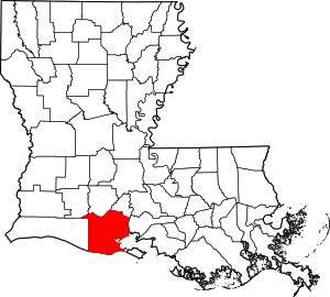 Location within the U.S. state of Louisiana | |
 Louisiana's location within the U.S. | |
| Coordinates: 29°49′N 92°19′W / 29.81°N 92.31°W | |
| Country | |
| State | |
| Founded | 1844 |
| Named for | Vermilion River and Bay |
| Seat | Abbeville |
| Largest city | Abbeville |
| Area | |
| • Total | 1,542 sq mi (3,990 km2) |
| • Land | 1,173 sq mi (3,040 km2) |
| • Water | 369 sq mi (960 km2) 24% |
| Population (2010) | |
| • Total | 57,999 |
| • Estimate (2019) | 59,865 |
| • Density | 38/sq mi (15/km2) |
| Time zone | UTC−6 (Central) |
| • Summer (DST) | UTC−5 (CDT) |
| Congressional district | 3rd |
| Website | vermilionparishpolicejury |

Vermilion Parish (French: Paroisse de Vermillion) is a parish located in the U.S. state of Louisiana, created in 1844.[1] The parish seat is Abbeville.[2] Vermilion Parish is part of the Lafayette metropolitan statistical area, and located in southern Acadiana. At the 2010 U.S. census, the population was 57,999;[3] the 2019 American Community Survey estimated its population was 59,865.[4]
Vermilion and neighboring Cameron parishes are represented in the Louisiana State Senate by the Republican Jonathan W. Perry of Kaplan. In the past several decades, much of the southern portion of the parish has been swept away by water erosion, especially after Hurricane Katrina and Hurricane Rita in 2005.
History[]
Indigenous peoples lived in the area for thousands of years, from different cultures. By historic times, the Chitimacha and Atakapa inhabited the area and were the American Indians encountered by Spanish and French explorers and settlers. The tribes' numbers were drastically reduced as a result of exposure to European diseases to which they had no immunity.
French, Spanish, enslaved Africans, and French-Canadians from Acadia expelled after the Seven Years' War won by Great Britain, had all entered the area by the end of the 18th century. As the population became mostly Cajun, the primary language was French for years. In the mid- to late 19th century, they were joined by European Americans; immigrants from Italy, recruited to work on the plantations, as well as Jewish immigrants from Germany and eastern Europe,[why?] who tended to settle in towns and become merchants.
Geography[]
According to the U.S. Census Bureau, the parish has a total area of 1,542 square miles (3,990 km2), of which 1,173 square miles (3,040 km2) is land and 369 square miles (960 km2) (24%) is water.[5] It is the fifth-largest parish in Louisiana by total area. The Gulf of Mexico is located to the south of the parish.
Major highways[]
 U.S. Highway 167
 Louisiana Highway 13
 Louisiana Highway 14
 Louisiana Highway 82
Adjacent parishes[]
- Acadia Parish (north)
- Lafayette Parish (northeast)
- Iberia Parish (east)
- Cameron Parish (west)
- Jefferson Davis Parish (northwest)
Communities[]
Cities[]
Towns[]
Village[]
Unincorporated communities[]
Demographics[]
| Historical population | |||
|---|---|---|---|
| Census | Pop. | %± | |
| 1850 | 3,409 | — | |
| 1860 | 4,324 | 26.8% | |
| 1870 | 4,528 | 4.7% | |
| 1880 | 8,728 | 92.8% | |
| 1890 | 14,234 | 63.1% | |
| 1900 | 20,705 | 45.5% | |
| 1910 | 26,390 | 27.5% | |
| 1920 | 26,482 | 0.3% | |
| 1930 | 33,684 | 27.2% | |
| 1940 | 37,750 | 12.1% | |
| 1950 | 36,929 | −2.2% | |
| 1960 | 38,855 | 5.2% | |
| 1970 | 43,071 | 10.9% | |
| 1980 | 48,458 | 12.5% | |
| 1990 | 50,055 | 3.3% | |
| 2000 | 53,807 | 7.5% | |
| 2010 | 57,999 | 7.8% | |
| 2019 (est.) | 59,865 | [6] | 3.2% |
| U.S. Decennial Census[7] 1790-1960[8] 1900-1990[9] 1990-2000[10] 2010-2013[3] | |||
Home to a number of Cajun peoples, at the 2000 U.S. census,[11] there were 53,807 people, 19,832 households, and 14,457 families residing in the parish. The population density was 46 people per square mile (18/km2). At the 2019 American Community Survey, there were 59,865 people living in the parish, up from 57,999 at the 2010 U.S. census.[4]
In 2000, were 22,461 housing units at an average density of 19 per square mile (7/km2). The racial makeup of the parish was 82.68% White, 14.17% Black or African American, 0.30% Native American, 1.82% Asian, 0.01% Pacific Islander, 0.26% from other races, and 0.76% from two or more races; 1.38% of the population were Hispanic or Latin American of any race; 24.89% reported speaking French or Cajun French at home, while 1.64% speak Vietnamese and 1.02% Spanish. In 2019, the racial and ethnic makeup was 81.4% non-Hispanic white, 14.5% Black and African American, 0.5% Native American, 2.0% Asian, 0.1% Pacific Islander, 0.4% some other race, and 1.1% from two or more races. An estimated 3.5% of the population were Hispanic and Latin American of any race.[4]
At the 2000 U.S. census, there were 19,832 households, out of which 37.10% had children under the age of 18 living with them, 55.50% were married couples living together, 13.00% had a female householder with no husband present, and 27.10% were non-families. 23.10% of all households were made up of individuals, and 10.90% had someone living alone who was 65 years of age or older. The average household size was 2.67 and the average family size was 3.16. The 2019 American Community Survey determined there were 22,086 households and 26,586 housing units; there was a home-ownership rate of 77% and the median housing value was $122,200. The median gross rent from 2015 to 2019 was $685.
In 2019, the median income for a household in the parish was $51,945; males had a median income of $53,658 versus $33,327 for females.[4] About 21.3% of the children under 18 lived at or below the poverty line, and 17.6% of the total population was below the poverty line. The median income for a household in the parish was $29,500, and the median income for a family was $36,093 in 2000. Males had a median income of $31,044 versus $18,710 for females. The per capita income for the parish was $14,201. About 17.40% of families and 22.10% of the population were below the poverty line, including 30.00% of those under age 18 and 21.40% of those age 65 or over.
Education[]
Vermilion Parish School Board operates public schools in the parish. However, the schools serving Delcambre are located in Vermilion Parish and are operated by Iberia Parish School System.
Schools[]
Public Schools that are run by the Vermilion Parish School Board include:
- Cecil Picard Elementary (Grades PK-5) (Maurice)
- Dozier Elementary (Grades PK-5) (Erath)
- Eaton Park Elementary (Grades PK-2) (Abbeville)
- Forked Island - E. Broussard Elementary (Grades PK-8) (Abbeville)
- Indian Bayou Elementary (Grades PK-5) (Rayne)
- James A. Herod Elementary (Grades 3–5) (Abbeville)
- Jesse Owens Elementary (Grades PK-5) (Gueydan)
- Kaplan Elementary (Grades PK-4) (Kaplan)
- Leblanc Elementary (Grades PK-5) (Abbeville)
- Meaux Elementary (Grades PK-5) (Abbeville)
- Seventh Ward Elementary (Grades PK-5) (Abbeville)
- Erath Middle (Grades 6–8) (Erath)
- J. H. Williams Middle (Grades 6–8) (Abbeville)
- North Vermilion Middle (Grades 6–8) (Maurice)
- Rene A. Rost Middle (Grades 5–8) (Kaplan)
- Abbeville High (Grades 9-12) (Abbeville)
- Erath High School (Grades 9-12) (Erath)
- Gueydan High (Grades 6-12) (Gueydan)
- Kaplan High (Grades 9-12) (Kaplan)
- North Vermilion High (Grades 9-12) (Maurice)
Vermilion Parish is also served by the Diocese of Lafayette with three schools:
- Maltrait Memorial School (Grades PK-8) (Kaplan)
- Mt. Carmel Catholic School (Grades PK-8) (Abbeville)
- Vermilion Catholic High School (Grades 9-12) (Abbeville)
Additionally, Vermilion Parish is served by two unaffiliated private school:
- Harvest Time Christian Academy (Grades PK-12) (Abbeville)
- Lighthouse Christian High School (Grades 9-12) (Abbeville)
Vermilion Parish is served by one institution of higher education:
- South Louisiana Community College service area,[12] Gulf Area Campus (Abbeville)
Politics[]
See also[]
| Wikimedia Commons has media related to Vermilion Parish, Louisiana. |
References[]
- ^ "Vermilion Parish". Center for Cultural and Eco-Tourism. Retrieved September 5, 2014.
- ^ "Find a County". National Association of Counties. Archived from the original on May 31, 2011. Retrieved 2011-06-07.
- ^ Jump up to: a b "State & County QuickFacts". United States Census Bureau. Retrieved August 18, 2013.
- ^ Jump up to: a b c d "Geography Profile: Vermilion Parish, Louisiana". data.census.gov. Retrieved 2021-08-10.
- ^ "2010 Census Gazetteer Files". United States Census Bureau. August 22, 2012. Archived from the original on September 28, 2013. Retrieved September 2, 2014.
- ^ "Population and Housing Unit Estimates". Retrieved August 10, 2021.
- ^ "U.S. Decennial Census". United States Census Bureau. Retrieved September 2, 2014.
- ^ "Historical Census Browser". University of Virginia Library. Retrieved September 2, 2014.
- ^ "Population of Counties by Decennial Census: 1900 to 1990". United States Census Bureau. Retrieved September 2, 2014.
- ^ "Census 2000 PHC-T-4. Ranking Tables for Counties: 1990 and 2000" (PDF). United States Census Bureau. Retrieved September 2, 2014.
- ^ "U.S. Census website". United States Census Bureau. Retrieved 2008-01-31.
- ^ "Our Colleges". Louisiana's Technical and Community Colleges. Retrieved 2021-06-03.
- ^ Leip, David. "Dave Leip's Atlas of U.S. Presidential Elections". Uselectionatlas.org. Retrieved 2 December 2017.
External links[]
- Heinrich, P. V., 2006, White Lake 30 x 60 minute geologic quadrangle. Louisiana Geological Survey, Baton Rouge, Louisiana.
- Heinrich, P. V., J. Snead, and R. P. McCulloh, 2003, Crowley 30 x 60 minute geologic quadrangle. Louisiana Geological Survey, Baton Rouge, Louisiana.
- Official website
- Vermilion Historical Society
- Vermilion Parish Sheriff's Office
| show Places adjacent to Vermilion Parish, Louisiana |
|---|
| show Municipalities and communities of Vermilion Parish, Louisiana, United States |
|---|

| show Authority control |
|---|
- Louisiana parishes
- Vermilion Parish, Louisiana
- Parishes in Acadiana
- Acadiana
- 1844 establishments in Louisiana
- Populated places established in 1844