Molagnies
Molagnies | |
|---|---|
 Coat of arms | |
show Location of Molagnies | |
 Molagnies | |
| Coordinates: 49°31′16″N 1°43′24″E / 49.5211°N 1.7233°ECoordinates: 49°31′16″N 1°43′24″E / 49.5211°N 1.7233°E | |
| Country | France |
| Region | Normandy |
| Department | Seine-Maritime |
| Arrondissement | Dieppe |
| Canton | Gournay-en-Bray |
| Intercommunality | CC 4 rivières |
| Government | |
| • Mayor (2020–2026) | Christian Ducrocq[1] |
| Area 1 | 4.65 km2 (1.80 sq mi) |
| Population (Jan. 2018)[2] | 186 |
| • Density | 40/km2 (100/sq mi) |
| Time zone | UTC+01:00 (CET) |
| • Summer (DST) | UTC+02:00 (CEST) |
| INSEE/Postal code | 76440 /76220 |
| Elevation | 97–183 m (318–600 ft) (avg. 101 m or 331 ft) |
| 1 French Land Register data, which excludes lakes, ponds, glaciers > 1 km2 (0.386 sq mi or 247 acres) and river estuaries. | |


Molagnies is a commune in the Seine-Maritime department in the Normandy region in northern France.
Geography[]
A small farming village situated by the banks of the Epte river in the Pays de Bray, some 31 miles (50 km) east of Rouen on the D57 road and at the border with the department of Oise.
Heraldry[]
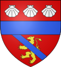 |
The arms of Molagnies are blazoned : Gules, a lion tail raised Or, overall a bend azure, and on a chief gules 3 escallops argent, and ??? a fess azure.
|
Population[]
| Year | Pop. | ±% p.a. |
|---|---|---|
| 1968 | 84 | — |
| 1975 | 75 | −1.61% |
| 1982 | 83 | +1.46% |
| 1990 | 119 | +4.61% |
| 1999 | 149 | +2.53% |
| 2007 | 152 | +0.25% |
| 2012 | 179 | +3.32% |
| 2017 | 167 | −1.38% |
| Source: INSEE[3] | ||
Places of interest[]
- The church of St. Manvieu, dating from the thirteenth century.
- A fifteenth century manorhouse.
See also[]
- Communes of the Seine-Maritime department
References[]
- ^ Liste des maires du département de la Seine-Maritime, 10 August 2020
- ^ "Populations légales 2018". INSEE. 28 December 2020.
- ^ Population en historique depuis 1968, INSEE
| Wikimedia Commons has media related to Molagnies. |
| show Communes of the Seine-Maritime department |
|---|
Categories:
- Communes of Seine-Maritime
- Dieppe geography stubs