Montaigu, Jura
Montaigu | |
|---|---|
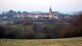 A general view of Montaigu | |
 Coat of arms | |
show Location of Montaigu | |
 Montaigu | |
| Coordinates: 46°39′37″N 5°34′10″E / 46.6603°N 5.5694°ECoordinates: 46°39′37″N 5°34′10″E / 46.6603°N 5.5694°E | |
| Country | France |
| Region | Bourgogne-Franche-Comté |
| Department | Jura |
| Arrondissement | Lons-le-Saunier |
| Canton | Poligny |
| Government | |
| • Mayor (2014–2020) | Martial Vincent |
| Area 1 | 7.10 km2 (2.74 sq mi) |
| Population (Jan. 2018)[1] | 422 |
| • Density | 59/km2 (150/sq mi) |
| Time zone | UTC+01:00 (CET) |
| • Summer (DST) | UTC+02:00 (CEST) |
| INSEE/Postal code | 39348 /39570 |
| Elevation | 270–544 m (886–1,785 ft) |
| 1 French Land Register data, which excludes lakes, ponds, glaciers > 1 km2 (0.386 sq mi or 247 acres) and river estuaries. | |


Montaigu is a commune in the Jura department in Bourgogne-Franche-Comté in eastern France.
Geography[]
The Vallière forms the commune's north-eastern border.
See also[]
References[]
- ^ "Populations légales 2018". INSEE. 28 December 2020.
| Wikimedia Commons has media related to Montaigu (Jura). |
This Jura geographical article is a stub. You can help Wikipedia by . |
Categories:
- Communes of Jura (department)
- Jura (department) geography stubs