Motteville
From Wikipedia, the free encyclopedia
Commune in Normandy, France
Motteville | |
|---|---|
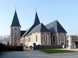 The church in Motteville | |
 Motteville  Motteville | |
Coordinates:  49°38′10″N 0°51′22″E / 49.6361°N 0.8561°E / 49.6361; 0.8561Coordinates: 49°38′10″N 0°51′22″E / 49.6361°N 0.8561°E / 49.6361; 0.8561 49°38′10″N 0°51′22″E / 49.6361°N 0.8561°E / 49.6361; 0.8561Coordinates: 49°38′10″N 0°51′22″E / 49.6361°N 0.8561°E / 49.6361; 0.8561 | |
| Country | France |
| Region | Normandy |
| Department | Seine-Maritime |
| Arrondissement | Rouen |
| Canton | Yvetot |
| Intercommunality | CC Plateau de Caux-Doudeville-Yerville |
| Government | |
| • Mayor (2020–2026) | Eric Halbourg |
| Area 1 | 8.68 km2 (3.35 sq mi) |
| Population (Jan. 2018)[1] | 778 |
| • Density | 90/km2 (230/sq mi) |
| Time zone | UTC+01:00 (CET) |
| • Summer (DST) | UTC+02:00 (CEST) |
| INSEE/Postal code | 76456 /76970 |
| Elevation | 135–157 m (443–515 ft) (avg. 150 m or 490 ft) |
| 1 French Land Register data, which excludes lakes, ponds, glaciers > 1 km2 (0.386 sq mi or 247 acres) and river estuaries. | |

Motteville is a commune in the Seine-Maritime department in the Normandy region in northern France.
Geography[]
A farming village situated in the Pays de Caux, some 22 miles (35 km) northwest of Rouen at the junction of the D20, D89, D53 and the D336 roads. SNCF operates a TER (train) train service here.
Population[]
| Year | Pop. | ±% p.a. |
|---|---|---|
| 1968 | 604 | — |
| 1975 | 620 | +0.37% |
| 1982 | 666 | +1.03% |
| 1990 | 706 | +0.73% |
| 1999 | 730 | +0.37% |
| 2007 | 730 | +0.00% |
| 2012 | 787 | +1.52% |
| 2017 | 791 | +0.10% |
| Source: INSEE[2] | ||
Places of interest[]
- The church of St.Michel, dating from the thirteenth century.
- The Château Henri IV
- The sixteenth century fortified manorhouse.
See also[]
- Communes of the Seine-Maritime department
References[]
- ^ "Populations légales 2018". INSEE. 28 December 2020.
- ^ Population en historique depuis 1968, INSEE
External links[]
| Wikimedia Commons has media related to Motteville. |
- Official website of the commune (in French)
show
Communes of the Seine-Maritime department | |
|---|---|
|
This Rouen geographical article is a stub. You can help Wikipedia by . |
- v
- t
Retrieved from ""
Categories:
- Communes of Seine-Maritime
- Rouen geography stubs
Hidden categories:
- Articles with short description
- Short description is different from Wikidata
- Infobox mapframe without OSM relation ID on Wikidata
- Coordinates on Wikidata
- Pages using infobox settlement with image map1 but not image map
- Commons category link from Wikidata
- Articles with French-language sources (fr)
- Articles with BNF identifiers
- All stub articles
- Pages using the Kartographer extension