Muchedent
From Wikipedia, the free encyclopedia
Commune in Normandy, France
Muchedent | |
|---|---|
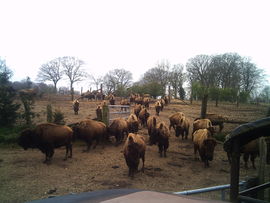 The bison farm | |
 Muchedent  Muchedent | |
Coordinates:  49°46′21″N 1°10′59″E / 49.7725°N 1.1831°E / 49.7725; 1.1831Coordinates: 49°46′21″N 1°10′59″E / 49.7725°N 1.1831°E / 49.7725; 1.1831 49°46′21″N 1°10′59″E / 49.7725°N 1.1831°E / 49.7725; 1.1831Coordinates: 49°46′21″N 1°10′59″E / 49.7725°N 1.1831°E / 49.7725; 1.1831 | |
| Country | France |
| Region | Normandy |
| Department | Seine-Maritime |
| Arrondissement | Dieppe |
| Canton | Luneray |
| Intercommunality | CC Terroir de Caux |
| Government | |
| • Mayor (2020–2026) | Christine Cressent[1] |
| Area 1 | 7.05 km2 (2.72 sq mi) |
| Population (Jan. 2018)[2] | 129 |
| • Density | 18/km2 (47/sq mi) |
| Time zone | UTC+01:00 (CET) |
| • Summer (DST) | UTC+02:00 (CEST) |
| INSEE/Postal code | 76458 /76590 |
| Elevation | 43–176 m (141–577 ft) (avg. 60 m or 200 ft) |
| 1 French Land Register data, which excludes lakes, ponds, glaciers > 1 km2 (0.386 sq mi or 247 acres) and river estuaries. | |

Muchedent is a commune in the Seine-Maritime department in the Normandy region in north-western France.
Geography[]
A small farming village situated by the banks of the river Varenne in the Pays de Caux, some 13 miles (21 km) south of Dieppe at the junction of the D77, the D154 and the D476 roads.
Population[]
| Year | Pop. | ±% p.a. |
|---|---|---|
| 1968 | 112 | — |
| 1975 | 115 | +0.38% |
| 1982 | 96 | −2.55% |
| 1990 | 117 | +2.50% |
| 1999 | 129 | +1.09% |
| 2007 | 118 | −1.11% |
| 2012 | 139 | +3.33% |
| 2017 | 131 | −1.18% |
| Source: INSEE[3] | ||
Places of interest[]
- The bison farm.
- The church of St. Pierre, dating from the eleventh century.
- A nineteenth century château.
See also[]
- Communes of the Seine-Maritime department
References[]
- ^ Maires au 17-06-2020, data.gouv.fr, accessed 7 December 2020
- ^ "Populations légales 2018". INSEE. 28 December 2020.
- ^ Population en historique depuis 1968, INSEE
External links[]
| Wikimedia Commons has media related to Muchedent. |
- Website of the bison farm (in French)
show
Communes of the Seine-Maritime department | |
|---|---|
|
This Dieppe geographical article is a stub. You can help Wikipedia by . |
- v
- t
Retrieved from ""
Categories:
- Communes of Seine-Maritime
- Dieppe geography stubs
Hidden categories:
- Articles with short description
- Short description is different from Wikidata
- Infobox mapframe without OSM relation ID on Wikidata
- Coordinates on Wikidata
- Pages using infobox settlement with image map1 but not image map
- Commons category link from Wikidata
- Articles with French-language sources (fr)
- Articles with BNF identifiers
- All stub articles
- Pages using the Kartographer extension