Mur-de-Barrez
show This article may be expanded with text translated from the corresponding article in French. (December 2008) Click [show] for important translation instructions. |
Mur-de-Barrez | |
|---|---|
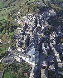 An aerial view of Mur-de-Barrez | |
 Coat of arms | |
show Location of Mur-de-Barrez | |
 Mur-de-Barrez | |
| Coordinates: 44°50′35″N 2°39′44″E / 44.8431°N 2.6622°ECoordinates: 44°50′35″N 2°39′44″E / 44.8431°N 2.6622°E | |
| Country | France |
| Region | Occitanie |
| Department | Aveyron |
| Arrondissement | Rodez |
| Canton | Aubrac et Carladez |
| Government | |
| • Mayor (2008–2014) | Alain Cézac |
| Area 1 | 20.18 km2 (7.79 sq mi) |
| Population (Jan. 2018)[1] | 730 |
| • Density | 36/km2 (94/sq mi) |
| Time zone | UTC+01:00 (CET) |
| • Summer (DST) | UTC+02:00 (CEST) |
| INSEE/Postal code | 12164 /12600 |
| Elevation | 653–953 m (2,142–3,127 ft) (avg. 780 m or 2,560 ft) |
| 1 French Land Register data, which excludes lakes, ponds, glaciers > 1 km2 (0.386 sq mi or 247 acres) and river estuaries. | |


Mur-de-Barrez is a commune in the Aveyron department in southern France.
Population[]
| Year | Pop. | ±% |
|---|---|---|
| 1962 | 1,277 | — |
| 1968 | 1,280 | +0.2% |
| 1975 | 1,305 | +2.0% |
| 1982 | 1,235 | −5.4% |
| 1990 | 1,109 | −10.2% |
| 1999 | 880 | −20.6% |
| 2008 | 821 | −6.7% |
See also[]
References[]
- ^ "Populations légales 2018". INSEE. 28 December 2020.
| Wikimedia Commons has media related to Mur-de-Barrez. |
| show Authority control |
|---|
This Aveyron geographical article is a stub. You can help Wikipedia by . |
Categories:
- Communes of Aveyron
- Aveyron geography stubs