Murasson
show This article may be expanded with text translated from the corresponding article in French. (December 2008) Click [show] for important translation instructions. |
Murasson | |
|---|---|
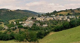 A general view of Murasson | |
show Location of Murasson | |
 Murasson | |
| Coordinates: 43°45′40″N 2°45′54″E / 43.7611°N 2.765°ECoordinates: 43°45′40″N 2°45′54″E / 43.7611°N 2.765°E | |
| Country | France |
| Region | Occitanie |
| Department | Aveyron |
| Arrondissement | Millau |
| Canton | Causses-Rougiers |
| Government | |
| • Mayor (2020–2026) | Michèle Sicard |
| Area 1 | 40.25 km2 (15.54 sq mi) |
| Population (Jan. 2018)[1] | 202 |
| • Density | 5.0/km2 (13/sq mi) |
| Time zone | UTC+01:00 (CET) |
| • Summer (DST) | UTC+02:00 (CEST) |
| INSEE/Postal code | 12163 /12370 |
| Elevation | 473–1,013 m (1,552–3,323 ft) (avg. 600 m or 2,000 ft) |
| 1 French Land Register data, which excludes lakes, ponds, glaciers > 1 km2 (0.386 sq mi or 247 acres) and river estuaries. | |


Murasson (French pronunciation: [myʁasɔ̃]) is a commune in the Aveyron department in southern France.
Population[]
|
|
See also[]
References[]
- ^ "Populations légales 2018". INSEE. 28 December 2020.
| Wikimedia Commons has media related to Murasson. |
| show Authority control |
|---|
This Aveyron geographical article is a stub. You can help Wikipedia by . |
Categories:
- Communes of Aveyron
- Aveyron geography stubs