Norville
From Wikipedia, the free encyclopedia
For other uses, see Norville (disambiguation).
Commune in Normandy, France
Norville | |
|---|---|
 The church in Norville | |
 Norville  Norville | |
Coordinates:  49°28′35″N 0°38′23″E / 49.4764°N 0.6397°E / 49.4764; 0.6397Coordinates: 49°28′35″N 0°38′23″E / 49.4764°N 0.6397°E / 49.4764; 0.6397 49°28′35″N 0°38′23″E / 49.4764°N 0.6397°E / 49.4764; 0.6397Coordinates: 49°28′35″N 0°38′23″E / 49.4764°N 0.6397°E / 49.4764; 0.6397 | |
| Country | France |
| Region | Normandy |
| Department | Seine-Maritime |
| Arrondissement | Le Havre |
| Canton | Port-Jérôme-sur-Seine |
| Intercommunality | Caux Seine Agglo |
| Government | |
| • Mayor (2020–2026) | Reynald Hauchard[1] |
| Area 1 | 11.69 km2 (4.51 sq mi) |
| Population (Jan. 2018)[2] | 993 |
| • Density | 85/km2 (220/sq mi) |
| Time zone | UTC+01:00 (CET) |
| • Summer (DST) | UTC+02:00 (CEST) |
| INSEE/Postal code | 76471 /76330 |
| Elevation | 0–131 m (0–430 ft) (avg. 50 m or 160 ft) |
| 1 French Land Register data, which excludes lakes, ponds, glaciers > 1 km2 (0.386 sq mi or 247 acres) and river estuaries. | |

Norville is a commune in the Seine-Maritime department in the Normandy region in northern France.
Geography[]
A farming village in the Pays de Caux, situated by the banks of the river Seine, some 23 miles (37 km) east yof Le Havre, at the junction of the D81 and D281 roads.
Population[]
| Year | Pop. | ±% p.a. |
|---|---|---|
| 1968 | 674 | — |
| 1975 | 825 | +2.93% |
| 1982 | 836 | +0.19% |
| 1990 | 827 | −0.14% |
| 1999 | 807 | −0.27% |
| 2007 | 886 | +1.17% |
| 2012 | 902 | +0.36% |
| 2017 | 987 | +1.82% |
| Source: INSEE[3] | ||
Places of interest[]
- The church of St. Martin, dating from the thirteenth century.
- A fifteenth century manorhouse .
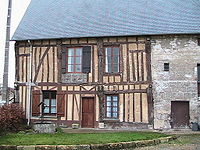
The manor
See also[]
- Communes of the Seine-Maritime department
References[]
- ^ "Répertoire national des élus: les maires". data.gouv.fr, Plateforme ouverte des données publiques françaises (in French). 2 December 2020.
- ^ "Populations légales 2018". INSEE. 28 December 2020.
- ^ Population en historique depuis 1968, INSEE
| Wikimedia Commons has media related to Norville. |
show
Communes of the Seine-Maritime department | |
|---|---|
|
| show Authority control | |
|---|---|
| General |
|
| National libraries | |
This Le Havre geographical article is a stub. You can help Wikipedia by . |
- v
- t
Retrieved from ""
Categories:
- Communes of Seine-Maritime
- Le Havre geography stubs
Hidden categories:
- CS1 French-language sources (fr)
- Articles with short description
- Short description is different from Wikidata
- Infobox mapframe without OSM relation ID on Wikidata
- Coordinates on Wikidata
- Pages using infobox settlement with image map1 but not image map
- Commons category link from Wikidata
- Articles with VIAF identifiers
- Articles with BNF identifiers
- Articles with WorldCat-VIAF identifiers
- All stub articles
- Pages using the Kartographer extension