Omonville
From Wikipedia, the free encyclopedia
Commune in Normandy, France
Omonville | |
|---|---|
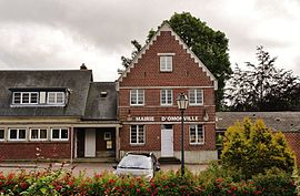 The town hall in Omonville | |
 Omonville  Omonville | |
Coordinates:  49°47′52″N 1°02′53″E / 49.7978°N 1.0481°E / 49.7978; 1.0481Coordinates: 49°47′52″N 1°02′53″E / 49.7978°N 1.0481°E / 49.7978; 1.0481 49°47′52″N 1°02′53″E / 49.7978°N 1.0481°E / 49.7978; 1.0481Coordinates: 49°47′52″N 1°02′53″E / 49.7978°N 1.0481°E / 49.7978; 1.0481 | |
| Country | France |
| Region | Normandy |
| Department | Seine-Maritime |
| Arrondissement | Dieppe |
| Canton | Luneray |
| Intercommunality | CC Terroir de Caux |
| Government | |
| • Mayor (2020–2026) | René Havard[1] |
| Area 1 | 2.83 km2 (1.09 sq mi) |
| Population (Jan. 2018)[2] | 265 |
| • Density | 94/km2 (240/sq mi) |
| Time zone | UTC+01:00 (CET) |
| • Summer (DST) | UTC+02:00 (CEST) |
| INSEE/Postal code | 76485 /76730 |
| Elevation | 104–131 m (341–430 ft) (avg. 124 m or 407 ft) |
| 1 French Land Register data, which excludes lakes, ponds, glaciers > 1 km2 (0.386 sq mi or 247 acres) and river estuaries. | |

Omonville is a commune in the Seine-Maritime department in the Normandy region in northern France.
Geography[]
A farming village situated in the Pays de Caux at the junction of the D102 and the D927 roads, some 10 miles (16 km) south of Dieppe.
Population[]
| Year | Pop. | ±% p.a. |
|---|---|---|
| 1968 | 285 | — |
| 1975 | 278 | −0.35% |
| 1982 | 291 | +0.66% |
| 1990 | 263 | −1.26% |
| 1999 | 255 | −0.34% |
| 2007 | 273 | +0.86% |
| 2012 | 268 | −0.37% |
| 2017 | 262 | −0.45% |
| Source: INSEE[3] | ||
Places of interest[]
- The church of Notre-Dame, dating from the nineteenth century.
- The château and park.
See also[]
- Communes of the Seine-Maritime department
References[]
- ^ Liste des maires du département de la Seine-Maritime, 10 August 2020
- ^ "Populations légales 2018". INSEE. 28 December 2020.
- ^ Population en historique depuis 1968, INSEE
| Wikimedia Commons has media related to Omonville. |
show
Communes of the Seine-Maritime department | |
|---|---|
|
This Dieppe geographical article is a stub. You can help Wikipedia by . |
- v
- t
Retrieved from ""
Categories:
- Communes of Seine-Maritime
- Dieppe geography stubs
Hidden categories:
- Articles with short description
- Short description is different from Wikidata
- Infobox mapframe without OSM relation ID on Wikidata
- Coordinates on Wikidata
- Pages using infobox settlement with image map1 but not image map
- Commons category link from Wikidata
- Articles with BNF identifiers
- All stub articles
- Pages using the Kartographer extension