Oudalle
Oudalle | |
|---|---|
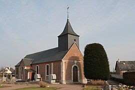 The church in Oudalle | |
 Coat of arms | |
show Location of Oudalle | |
 Oudalle | |
| Coordinates: 49°30′23″N 0°17′57″E / 49.5064°N 0.2992°ECoordinates: 49°30′23″N 0°17′57″E / 49.5064°N 0.2992°E | |
| Country | France |
| Region | Normandy |
| Department | Seine-Maritime |
| Arrondissement | Le Havre |
| Canton | Saint-Romain-de-Colbosc |
| Intercommunality | Le Havre Seine Métropole |
| Area 1 | 9.65 km2 (3.73 sq mi) |
| Population (Jan. 2018)[1] | 429 |
| • Density | 44/km2 (120/sq mi) |
| Time zone | UTC+01:00 (CET) |
| • Summer (DST) | UTC+02:00 (CEST) |
| INSEE/Postal code | 76489 /76430 |
| Elevation | 0–109 m (0–358 ft) (avg. 90 m or 300 ft) |
| 1 French Land Register data, which excludes lakes, ponds, glaciers > 1 km2 (0.386 sq mi or 247 acres) and river estuaries. | |


Oudalle is a commune in the Seine-Maritime department in the Normandy region in northern France.
Geography[]
A village with light industry in its southern sector and farming in the northern part, in the Pays de Caux, situated some 8 miles (13 km) east of Le Havre, at the junction of the A131 autoroute with junction 5 of the A29 autoroute as it crosses the canal de Tancarville, the canal du Havre and the river Seine.
Heraldry[]
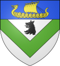 |
The arms of Oudalle are blazoned : Argent, a chevron inverted vert in chief a wolf head erased sable, and on a chief azure, a drakkar Or.
|
Population[]
| Year | Pop. | ±% p.a. |
|---|---|---|
| 1968 | 151 | — |
| 1975 | 183 | +2.78% |
| 1982 | 252 | +4.68% |
| 1990 | 330 | +3.43% |
| 1999 | 368 | +1.22% |
| 2007 | 357 | −0.38% |
| 2012 | 404 | +2.50% |
| 2017 | 440 | +1.72% |
| Source: INSEE[2] | ||
Places of interest[]
- The church of St.Pierre, dating from the eighteenth century.
See also[]
- Communes of the Seine-Maritime department
References[]
- ^ "Populations légales 2018". INSEE. 28 December 2020.
- ^ Population en historique depuis 1968, INSEE
| Wikimedia Commons has media related to Oudalle. |
| show Communes of the Seine-Maritime department |
|---|
Categories:
- Communes of Seine-Maritime
- Le Havre geography stubs