Perşembe
Perşembe | |
|---|---|
District | |
 Location of Perşembe within Turkey | |
 Perşembe Location of Perşembe | |
| Coordinates: 41°04′N 37°46′E / 41.067°N 37.767°E | |
| Country | |
| Region | Black Sea |
| Province | Ordu |
| Government | |
| • Mayor | Kemal Bahtiyar (AKP) |
| Area | |
| • District | 236.99 km2 (91.50 sq mi) |
| Elevation | 0 m (0 ft) |
| Population (2012)[2] | |
| • Urban | 9,168 |
| • District | 32,150 |
| • District density | 140/km2 (350/sq mi) |
| Time zone | UTC+2 (EET) |
| • Summer (DST) | UTC+3 (EEST) |
| Postal code | 52750 |
| Area code(s) | 0452 |
| Licence plate | 52 |
| Climate | Cfa |
| Website | www.persembe.bel.tr |

Perşembe (Turkish: Perşembe,originated from Persian word "پنج شنبه(/pændʒʃænbɛ/)" meaning Thursday) (formerly Vona, Βόνη in ancient Greek, also Heneti, ჰენეთი in Georgian and Laz languages) is a town and district of Ordu Province on the Black Sea coast of Turkey. According to the 2016 census, population of the district is 31,065, with a male population of 15,966 and female population of 15,099.[3] The district covers an area of 237 km2 (92 sq mi),[4] and the town lies at an elevation of 0 m (0 ft).
Legend and history[]
Perşembe is on the on the Black Sea coast and is held to be the point where the legendary Jason and the Argonauts were forced to land during their struggle with the storms and currents of the Black Sea.
For a long time Vona was part of the Roman Empire and its successors the Byzantine Empire and Empire of Trebizond. This era ended in 1461 when Trebizond was overturned by Sultan Mehmet II and Vona was brought into the Ottoman Empire, although there was a Turkish (Chepni Tribes) community in the town before this date. By 1520 the port of Vona was a predominantly Muslim town.
The name of the town derives from the word پنجشنبه (penc-şenbe)for Thursday.
Villages[]
The villages of Perşembe district include Alınca, Anaç, Aziziye, Bekirli, Beyli, Boğazcık, Bolatlı, Çamarası, Çaytepe, Çerli, Doğanköy, Döngeldüzü, Efirli, Ekinciler, Gündoğdu, Hacılar, İmeçli, İstanbulboğazı, Kazancılı, Kovanlı, Kurtuluş, Kutluca, Kuyluca, Mersinköy, Neneli, Okçulu, Ortatepe, Ramazan, Sarayköy, Selimiye, Sırakovancı, Soğukpınar, Şenyurt, Tarlacık, Tepecik, Tepeköy, Yarlı, Yazlık, Yeniköy, Yeniöz, Yeşilköy, and Yumrutaş.
See also[]
Notes[]
- ^ "Area of regions (including lakes), km²". Regional Statistics Database. Turkish Statistical Institute. 2002. Retrieved 2013-03-05.
- ^ "Population of province/district centers and towns/villages by districts - 2012". Address Based Population Registration System (ABPRS) Database. Turkish Statistical Institute. Retrieved 2013-02-27.
- ^ "Nüfus". www.persembe.gov.tr. Retrieved 2021-08-23.
- ^ Statoids. "Statistical information on districts of Turkey". Retrieved 2009-05-15.
References[]
- Falling Rain Genomics, Inc. "Geographical information on Perşembe, Turkey". Retrieved 2009-05-15.
External links[]
![]() Media related to Perşembe at Wikimedia Commons
Media related to Perşembe at Wikimedia Commons
- District governor's official website (in Turkish)
- District municipality's official website (in Turkish)
- Road map of Perşembe and environs
- Various images of Perşembe, Ordu
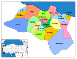
Perşembe in Ordu Province of Turkey | |||||||||||||||||||||||||||
|---|---|---|---|---|---|---|---|---|---|---|---|---|---|---|---|---|---|---|---|---|---|---|---|---|---|---|---|
| Districts | 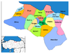 | ||||||||||||||||||||||||||
|
Metropolitan municipalities are bolded. | |||||||||||||||||||||||||||
Coordinates: 41°03′56″N 37°46′17″E / 41.06556°N 37.77139°E
This article about a Black Sea Region of Turkey location is a stub. You can help Wikipedia by . |
- Populated places in Ordu Province
- Populated coastal places in Turkey
- Districts of Ordu Province
- Cittaslow
- Black Sea Region geography stubs