Ulubey, Ordu
Ulubey | |
|---|---|
District | |
 Location of Ulubey within Turkey. | |
 Ulubey Location of Ulubey | |
| Coordinates: 40°53′N 37°44′E / 40.883°N 37.733°E | |
| Country | |
| Region | Black Sea |
| Province | Ordu |
| Government | |
| • Mayor | İsa Türkcan (AKP) |
| Area | |
| • District | 303.73 km2 (117.27 sq mi) |
| Elevation | 602 m (1,975 ft) |
| Population (2012)[2] | |
| • Urban | 5,290 |
| • District | 16,999 |
| • District density | 56/km2 (140/sq mi) |
| Time zone | UTC+2 (EET) |
| • Summer (DST) | UTC+3 (EEST) |
| Postal code | 52xxx |
| Area code(s) | 0452 |
| Licence plate | 52 |
| Climate | Cfb |
| Website | www.ulubey.bel.tr |

Ulubey is a town and district of Ordu Province in the Black Sea region of Turkey, 21 km (13 mi) south of the Black Sea in the Canik Mountains. The Melet River runs through the district. According to the 2000 census, population of the district is 29,227 of which 9,128 live in the town of Ulubey.[3] The district covers an area of 304 km2 (117 sq mi),[4] and the town lies at an elevation of 602 m (1,975 ft).
Economy[]
The economy of the district depends mainly on agriculture. Hazelnuts, beekeeping, dairy farming, corn, and kale are the main products. In recent decades the population has declined as people have migrated away to jobs in Turkey's larger cities or abroad, now mainly their grandparents remain.
Villages[]
The villages of Ulubey district include Akoluk, Akpınar, Aydınlar, Başçardak, Belenyurt, Cevizlik, Çağlayan, Çubuklu, Doğlu, Durakköy, Elmaçukuru, Eymür, Fındıklı, Güvenköy, Güvenyurt, Güzelyurt, Hocaoğlu, Kadıncık, Kalıcak, Kardeşler, Kıranyağmur, Kirazlık, Koşaca, Kumanlar, Kumrulu, Ohtamış, Oyumgürgen, Örenköy, Refahiye, Şahinkaya, Şekeroluk, Şeyhler, Uzunmahmut, Yenisayaca, and Yukarıkızılen.
Notes[]
- ^ "Area of regions (including lakes), km²". Regional Statistics Database. Turkish Statistical Institute. 2002. Retrieved 2013-03-05.
- ^ "Population of province/district centers and towns/villages by districts - 2012". Address Based Population Registration System (ABPRS) Database. Turkish Statistical Institute. Retrieved 2013-02-27.
- ^ Turkish Statistical Institute. "Census 2000, Key statistics for urban areas of Turkey" (in Turkish). Archived from the original (XLS) on 2007-07-22. Retrieved 2009-05-11.
- ^ Statoids. "Statistical information on districts of Turkey". Archived from the original on 2010-05-26. Retrieved 2009-05-11.
References[]
- Falling Rain Genomics, Inc. "Geographical information on Ulubey, Turkey". Retrieved 2009-05-11.
External links[]
- (in Turkish) District governor's official website
- (in Turkish) District municipality's official website
- Road map of Ulubey and environs
- Various images of Ulubey, Ordu
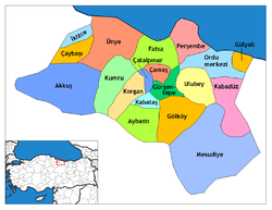
Ulubey, Ordu in Ordu Province of Turkey | |||||||||||||||||||||||||||
|---|---|---|---|---|---|---|---|---|---|---|---|---|---|---|---|---|---|---|---|---|---|---|---|---|---|---|---|
| Districts | 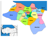 | ||||||||||||||||||||||||||
|
Metropolitan municipalities are bolded. | |||||||||||||||||||||||||||
Coordinates: 40°52′34″N 37°44′26″E / 40.87611°N 37.74056°E
This article about a Black Sea Region of Turkey location is a stub. You can help Wikipedia by . |
- Populated places in Ordu Province
- Districts of Ordu Province
- Black Sea Region geography stubs