Rolleville
Rolleville | |
|---|---|
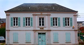 The town hall in Rolleville | |
 Coat of arms | |
show Location of Rolleville | |
 Rolleville | |
| Coordinates: 49°35′00″N 0°12′43″E / 49.5833°N 0.2119°ECoordinates: 49°35′00″N 0°12′43″E / 49.5833°N 0.2119°E | |
| Country | France |
| Region | Normandy |
| Department | Seine-Maritime |
| Arrondissement | Le Havre |
| Canton | Octeville-sur-Mer |
| Intercommunality | Le Havre Seine Métropole |
| Government | |
| • Mayor (2020–2026) | Pascal Leprettre |
| Area 1 | 7.06 km2 (2.73 sq mi) |
| Population (Jan. 2018)[1] | 1,189 |
| • Density | 170/km2 (440/sq mi) |
| Time zone | UTC+01:00 (CET) |
| • Summer (DST) | UTC+02:00 (CEST) |
| INSEE/Postal code | 76534 /76133 |
| Elevation | 27–107 m (89–351 ft) (avg. 45 m or 148 ft) |
| 1 French Land Register data, which excludes lakes, ponds, glaciers > 1 km2 (0.386 sq mi or 247 acres) and river estuaries. | |


Rolleville is a commune in the Seine-Maritime department in the Normandy region in northern France.
Geography[]
A farming village with some light industry, by the banks of the river Lézarde in the Pays de Caux, situated some 10 miles (16 km) northeast of Le Havre, on the D32 road. SNCF has a TER railway station here.
Heraldry[]
 |
The arms of Rolleville are blazoned : Vert, on a bend sinister wavy between a dovecot argent and a garb of flax Or, 3 millwheels gules.
|
Population[]
| Year | Pop. | ±% p.a. |
|---|---|---|
| 1968 | 910 | — |
| 1975 | 873 | −0.59% |
| 1982 | 1,022 | +2.28% |
| 1990 | 1,081 | +0.70% |
| 1999 | 1,131 | +0.50% |
| 2007 | 1,137 | +0.07% |
| 2012 | 1,130 | −0.12% |
| 2017 | 1,195 | +1.12% |
| Source: INSEE[2] | ||
Places of interest[]
- The nineteenth-century church of St. Hilaire.
- A sixteenth-century manorhouse.
See also[]
- Communes of the Seine-Maritime department
References[]
- ^ "Populations légales 2018". INSEE. 28 December 2020.
- ^ Population en historique depuis 1968, INSEE
External links[]
| Wikimedia Commons has media related to Rolleville. |
- An unofficial website about Rolleville (in French)
| show Communes of the Seine-Maritime department |
|---|
Categories:
- Communes of Seine-Maritime
- Le Havre geography stubs