Roxburgh County

From Wikipedia, the free encyclopedia

Map all coordinates using: OpenStreetMap 
Download coordinates as: KML
Roxburgh
New South Wales
Roxburgh NSW.PNG
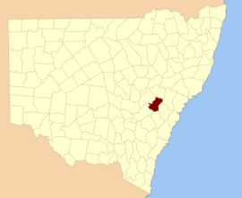
Location in New South Wales
Lands administrative divisions around Roxburgh:
Wellington Phillip Hunter
Wellington Roxburgh Cook
Bathurst Westmoreland Westmoreland
1872 map of Roxburgh County

Roxburgh County was one of the original Nineteen Counties in New South Wales and is now one of the 141 Cadastral divisions of New South Wales. It includes the area to the north east of Bathurst, lying to the north and east of the Fish River to the junction of the Turon River. It includes Sofala. The is the border to the north.

Roxburgh County named after the Scottish county of the same name. It was named in 1829.[1]

Parishes within this county[]

A full list of parishes found within this county; their current LGA and mapping coordinates to the approximate centre of each location is as follows:

Parish LGA Coordinates
City of Lithgow 33°04′54″S 150°00′04″E / 33.08167°S 150.00111°E / -33.08167; 150.00111 (Airly)
City of Lithgow 33°08′54″S 150°00′04″E / 33.14833°S 150.00111°E / -33.14833; 150.00111 (Bandamora)
Ben Bullen City of Lithgow 33°14′54″S 150°00′04″E / 33.24833°S 150.00111°E / -33.24833; 150.00111 (Ben Bullen)
Mid-Western Regional Council 32°50′54″S 149°48′04″E / 32.84833°S 149.80111°E / -32.84833; 149.80111 (Bocoble)
Bathurst Regional Council 33°05′54″S 149°26′04″E / 33.09833°S 149.43444°E / -33.09833; 149.43444 (Bruinbun)
Mid-Western Regional Council 32°50′54″S 150°06′04″E / 32.84833°S 150.10111°E / -32.84833; 150.10111 (Burrowoury)
Capertee City of Lithgow 32°59′54″S 150°06′04″E / 32.99833°S 150.10111°E / -32.99833; 150.10111 (Capertee)
Bathurst Regional Council 33°20′54″S 149°51′04″E / 33.34833°S 149.85111°E / -33.34833; 149.85111 (Castleton)
Clandulla City of Lithgow 32°57′54″S 150°00′04″E / 32.96500°S 150.00111°E / -32.96500; 150.00111 (Clandulla)
City of Lithgow 33°09′54″S 150°02′04″E / 33.16500°S 150.03444°E / -33.16500; 150.03444 (Coco)
City of Lithgow 33°18′54″S 149°55′04″E / 33.31500°S 149.91778°E / -33.31500; 149.91778 (Coolamigal)
Mid-Western Regional Council 32°59′54″S 149°41′04″E / 32.99833°S 149.68444°E / -32.99833; 149.68444 (Crudine)
Cullen Bullen City of Lithgow 33°17′54″S 149°59′04″E / 33.29833°S 149.98444°E / -33.29833; 149.98444 (Cullen Bullen)
City of Lithgow 33°09′54″S 149°49′04″E / 33.16500°S 149.81778°E / -33.16500; 149.81778 (Dulabree)
Bathurst Regional Council 33°15′54″S 149°34′04″E / 33.26500°S 149.56778°E / -33.26500; 149.56778 (Duramana)
Bathurst Regional Council 33°20′54″S 149°44′04″E / 33.34833°S 149.73444°E / -33.34833; 149.73444 (Eskdale)
Bathurst Regional Council 33°27′54″S 149°52′04″E / 33.46500°S 149.86778°E / -33.46500; 149.86778 (Eusdale)
City of Lithgow 33°22′54″S 149°57′04″E / 33.38167°S 149.95111°E / -33.38167; 149.95111 (Falnash)
Mid-Western Regional Council 32°51′54″S 150°12′04″E / 32.86500°S 150.20111°E / -32.86500; 150.20111 (Ganguddy)
City of Lithgow 32°54′54″S 150°06′04″E / 32.91500°S 150.10111°E / -32.91500; 150.10111 (Goongal)
Mid-Western Regional Council 33°01′54″S 149°54′04″E / 33.03167°S 149.90111°E / -33.03167; 149.90111 (Hearne)
Bathurst Regional Council 33°20′54″S 149°33′04″E / 33.34833°S 149.55111°E / -33.34833; 149.55111 (Jedburgh)
Bathurst Regional Council 33°15′54″S 149°44′04″E / 33.26500°S 149.73444°E / -33.26500; 149.73444 (Jesse)
Kelso Bathurst Regional Council 33°26′54″S 149°37′04″E / 33.44833°S 149.61778°E / -33.44833; 149.61778 (Kelso)
Bathurst Regional Council 33°07′54″S 149°30′04″E / 33.13167°S 149.50111°E / -33.13167; 149.50111 (Macquarie)
Mid-Western Regional Council 32°55′54″S 149°54′04″E / 32.93167°S 149.90111°E / -32.93167; 149.90111 (Mead)
Bathurst Regional Council 33°26′54″S 149°43′04″E / 33.44833°S 149.71778°E / -33.44833; 149.71778 (Melrose)
Bathurst Regional Council 33°10′54″S 149��36′04″E / 33.18167°S 149.60111°E / -33.18167; 149.60111 (Millah Murrah)
City of Lithgow 33°04′54″S 150°07′04″E / 33.08167°S 150.11778°E / -33.08167; 150.11778 (Morundurey)
Peel Bathurst Regional Council 33°20′54″S 149°39′04″E / 33.34833°S 149.65111°E / -33.34833; 149.65111 (Peel)
Bathurst Regional Council 33°15′54″S 149°27′04″E / 33.26500°S 149.45111°E / -33.26500; 149.45111 (Piper)
Rylstone Mid-Western Regional Council 32°50′54″S 150°00′04″E / 32.84833°S 150.00111°E / -32.84833; 150.00111 (Rylstone)
Sofala Bathurst Regional Council 33°06′54″S 149°44′04″E / 33.11500°S 149.73444°E / -33.11500; 149.73444 (Sofala)
Stewart Mid-Western Regional Council 33°04′54″S 149°52′04″E / 33.08167°S 149.86778°E / -33.08167; 149.86778 (Stewart)
Mid-Western Regional Council 32°54′54″S 149°48′04″E / 32.91500°S 149.80111°E / -32.91500; 149.80111 (Tabrabucca)
City of Lithgow 32°55′54″S 150°13′04″E / 32.93167°S 150.21778°E / -32.93167; 150.21778 (Tayar)
City of Lithgow 33°29′54″S 149°58′04″E / 33.49833°S 149.96778°E / -33.49833; 149.96778 (Thornshope)
City of Lithgow 33°16′54″S 149°50′04″E / 33.28167°S 149.83444°E / -33.28167; 149.83444 (Turon)
City of Lithgow 32°59′54″S 150°13′04″E / 32.99833°S 150.21778°E / -32.99833; 150.21778 (Umbiella)
Mid-Western Regional Council 33°01′54″S 149°46′04″E / 33.03167°S 149.76778°E / -33.03167; 149.76778 (Walberton)
Bathurst Regional Council 33°16′54″S 149°31′04″E / 33.28167°S 149.51778°E / -33.28167; 149.51778 (Waltham)
Mid-Western Regional Council 32°59′54″S 149°50′04″E / 32.99833°S 149.83444°E / -32.99833; 149.83444 (Warrangunia)
Bathurst Regional Council 33°04′54″S 149°35′04″E / 33.08167°S 149.58444°E / -33.08167; 149.58444 (Waterbeach)
Bathurst Regional Council 33°19′54″S 149°27′04″E / 33.33167°S 149.45111°E / -33.33167; 149.45111 (Watton)
Mid-Western Regional Council 32°49′54″S 149°54′04″E / 32.83167°S 149.90111°E / -32.83167; 149.90111 (Wells)
Bathurst Regional Council 33°14′54″S 149°41′04″E / 33.24833°S 149.68444°E / -33.24833; 149.68444 (Wiagdon)
Bathurst Regional Council 33°16′54″S 149°39′04″E / 33.28167°S 149.65111°E��� / -33.28167; 149.65111 (Winburn)
Yetholme Bathurst Regional Council 33°28′54″S 149°47′04″E / 33.48167°S 149.78444°E / -33.48167; 149.78444 (Yetholme)

References[]

  1. ^ "Roxburgh". Geographical Names Register (GNR) of NSW. Geographical Names Board of New South Wales. Edit this at Wikidata
Map all coordinates using: OpenStreetMap 
Download coordinates as: KML
Retrieved from ""