Thaumiers
Thaumiers | |
|---|---|
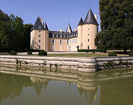 The Château of La Forêt | |
show Location of Thaumiers | |
 Thaumiers | |
| Coordinates: 46°49′20″N 2°39′21″E / 46.8222°N 2.6558°ECoordinates: 46°49′20″N 2°39′21″E / 46.8222°N 2.6558°E | |
| Country | France |
| Region | Centre-Val de Loire |
| Department | Cher |
| Arrondissement | Saint-Amand-Montrond |
| Canton | Dun-sur-Auron |
| Intercommunality | CC Le Dunois |
| Government | |
| • Mayor (2008–2014) | Philippe de Bonneval |
| Area 1 | 27.33 km2 (10.55 sq mi) |
| Population (Jan. 2018)[1] | 418 |
| • Density | 15/km2 (40/sq mi) |
| Time zone | UTC+01:00 (CET) |
| • Summer (DST) | UTC+02:00 (CEST) |
| INSEE/Postal code | 18261 /18210 |
| Elevation | 165–236 m (541–774 ft) (avg. 181 m or 594 ft) |
| 1 French Land Register data, which excludes lakes, ponds, glaciers > 1 km2 (0.386 sq mi or 247 acres) and river estuaries. | |


Thaumiers is a commune in the Cher department in the Centre-Val de Loire region of France.
Geography[]
An area of forestry and farming comprising the village and several hamlets situated about 21 miles (34 km) southeast of Bourges at the junction of the D41 with the D92 and D943 roads. The Auron River forms the western and southern boundaries of the commune.
Population[]
| Year | Pop. | ±% |
|---|---|---|
| 1962 | 487 | — |
| 1968 | 512 | +5.1% |
| 1975 | 427 | −16.6% |
| 1982 | 397 | −7.0% |
| 1990 | 383 | −3.5% |
| 1999 | 382 | −0.3% |
| 2008 | 416 | +8.9% |
Sights[]
- The eighteenth-century chateau of Thaumiers.
- The church of St. Saturnin, dating from the twelfth century.
- Some Roman remains: walls, tombs, vases, sculptures and an aqueduct.
- The fifteenth-century chateau of La Forêt.
- Ruins of the priory of Grandmont at Fontguédon.
See also[]
- Communes of the Cher department
References[]
- ^ "Populations légales 2018". INSEE. 28 December 2020.
External links[]
| Wikimedia Commons has media related to Thaumiers. |
- Annuaire Mairie website (in French)
| show Communes of the Cher department |
|---|
| show Authority control |
|---|
Categories:
- Communes of Cher (department)