Val-de-la-Haye
Val-de-la-Haye | |
|---|---|
 Coat of arms | |
show Location of Val-de-la-Haye | |
 Val-de-la-Haye | |
| Coordinates: 49°22′41″N 1°00′07″E / 49.378°N 1.002°ECoordinates: 49°22′41″N 1°00′07″E / 49.378°N 1.002°E | |
| Country | France |
| Region | Normandy |
| Department | Seine-Maritime |
| Arrondissement | Rouen |
| Canton | Canteleu |
| Intercommunality | Métropole Rouen Normandie |
| Government | |
| • Mayor (2014-2020) | Étienne Hebert |
| Area 1 | 10.16 km2 (3.92 sq mi) |
| Population (Jan. 2018)[1] | 715 |
| • Density | 70/km2 (180/sq mi) |
| Time zone | UTC+01:00 (CET) |
| • Summer (DST) | UTC+02:00 (CEST) |
| INSEE/Postal code | 76717 /76380 |
| Elevation | 2–119 m (6.6–390.4 ft) (avg. 15 m or 49 ft) |
| 1 French Land Register data, which excludes lakes, ponds, glaciers > 1 km2 (0.386 sq mi or 247 acres) and river estuaries. | |


Val-de-la-Haye is a commune in the Seine-Maritime department in the Normandy region in north-western France.
Geography[]
A forestry and light industrial village situated by the banks of the Seine, some 6 miles (9.7 km) southwest of Rouen on the D 51 road. A car ferry connects with the commune of Petit-Couronne on the opposite bank.
Heraldry[]
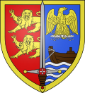 |
The arms of the commune of Val-de-la-Haye are blazoned : Per pale 1: gules, 2 demi-leopards issuant from the line of division and 2: azure, a boat proper issuant from sinister sailing on a base barry wavy azure and argent, and in chief an imperial French eagle Or grasping a lightning bolt argent; over the per pale line of division, a sword throughout argent garnished proper, the guard has argent blobs at the tips, and is charged with a lozenge argent charged with a Maltese cross; and the pommel is charged with a torteau [gules]; the entire shield fimbriated Or.
|
Population[]
| Year | Pop. | ±% |
|---|---|---|
| 1793 | 775 | — |
| 1800 | 700 | −9.7% |
| 1806 | 707 | +1.0% |
| 1821 | 595 | −15.8% |
| 1831 | 602 | +1.2% |
| 1836 | 601 | −0.2% |
| 1841 | 552 | −8.2% |
| 1846 | 519 | −6.0% |
| 1851 | 519 | +0.0% |
| 1856 | 497 | −4.2% |
| 1861 | 478 | −3.8% |
| 1866 | 468 | −2.1% |
| 1872 | 385 | −17.7% |
| 1876 | 384 | −0.3% |
| 1881 | 393 | +2.3% |
| 1886 | 417 | +6.1% |
| 1891 | 382 | −8.4% |
| 1896 | 367 | −3.9% |
| 1901 | 359 | −2.2% |
| 1906 | 331 | −7.8% |
| 1911 | 372 | +12.4% |
| 1921 | 397 | +6.7% |
| 1926 | 370 | −6.8% |
| 1931 | 437 | +18.1% |
| 1936 | 434 | −0.7% |
| 1946 | 582 | +34.1% |
| 1954 | 765 | +31.4% |
| 1962 | 729 | −4.7% |
| 1968 | 754 | +3.4% |
| 1975 | 669 | −11.3% |
| 1982 | 715 | +6.9% |
| 1990 | 805 | +12.6% |
| 1999 | 789 | −2.0% |
| 2006 | 751 | −4.8% |
| 2007 | 746 | −0.7% |
| 2008 | 732 | −1.9% |
| 2009 | 723 | −1.2% |
| 2010 | 720 | −0.4% |
| 2011 | 718 | −0.3% |
| 2012 | 716 | −0.3% |
| 2013 | 705 | −1.5% |
| 2014 | 694 | −1.6% |
Places of interest[]
- The church of St. Jean-Baptiste, dating from the twentieth century.
- Vestiges of the thirteenth-century Templars’ Sainte-Vaubourg commandery.
- A commemorative stone column topped with a bronze eagle, built in 1846.
See also[]
- Communes of the Seine-Maritime department
References[]
- ^ "Populations légales 2018". INSEE. 28 December 2020.
External links[]
| Wikimedia Commons has media related to Val-de-la-Haye. |
- Official town website (in French)
| show Communes of the Seine-Maritime department |
|---|
Categories:
- Communes of Seine-Maritime
- Rouen geography stubs