Yport
This article includes a list of references, related reading or external links, but its sources remain unclear because it lacks inline citations. (August 2014) |
Yport | |
|---|---|
 The upstream cliffs | |
 Coat of arms | |
show Location of Yport | |
 Yport | |
| Coordinates: 49°44′19″N 0°18′50″E / 49.7386°N 0.3139°ECoordinates: 49°44′19″N 0°18′50″E / 49.7386°N 0.3139°E | |
| Country | France |
| Region | Normandy |
| Department | Seine-Maritime |
| Arrondissement | Le Havre |
| Canton | Fécamp |
| Intercommunality | Fécamp Caux Littoral |
| Government | |
| • Mayor (2014-2020) | Alain Charpy |
| Area 1 | 2.07 km2 (0.80 sq mi) |
| Population (Jan. 2018)[1] | 762 |
| • Density | 370/km2 (950/sq mi) |
| Time zone | UTC+01:00 (CET) |
| • Summer (DST) | UTC+02:00 (CEST) |
| INSEE/Postal code | 76754 /76111 |
| Elevation | 0–96 m (0–315 ft) (avg. 30 m or 98 ft) |
| 1 French Land Register data, which excludes lakes, ponds, glaciers > 1 km2 (0.386 sq mi or 247 acres) and river estuaries. | |


Yport is a commune in the Seine-Maritime department in the Normandy region in northern France. The residents are known as Yportais or Yportaises.
Location[]
Yport is located on the D104 road, about 19 miles (31 km) north of Le Havre, on the coast of the English Channel.
Population[]
| Year | Pop. | ±% |
|---|---|---|
| 2004 | 1,035 | — |
| 2006 | 1,034 | −0.1% |
| 2007 | 1,005 | −2.8% |
| 2008 | 976 | −2.9% |
| 2009 | 947 | −3.0% |
| 2010 | 949 | +0.2% |
| 2011 | 963 | +1.5% |
| 2012 | 923 | −4.2% |
| 2013 | 884 | −4.2% |
| 2014 | 845 | −4.4% |
| 2015 | 838 | −0.8% |
| 2016 | 834 | −0.5% |
History[]
The site was probably occupied during the neolithic period, and later the Pays de Caux was inhabited by the Calates. During the Roman time, a road connecting Fécamp to Étretat passed through the locality at Pitron Fund from where a junction towards the village existed. The current D940 follows the route of this Roman road. The Roman presence was discovered following various archaeological excavations but nothing proves that it was permanently inhabited. It may have been only a fishing site. Starting from the early Middle Ages the village was attached to Criquebeuf-en-Caux, where the church, the cemetery and the school were located, several kilometres away from Yport. Only in the 19th century did the commune of Yport come into existence, primarily because of the construction of the church. Officially, the commune of Yport was created on January 1, 1843 and its first mayor was Jean-Baptiste Feuilloley. The 19th century marked the beginning of the rise of sea-fishing. Many people were attracted to the area by the work and the population reached 1800. The sea front evolved considerably during this period. As a working port, the sea front had fishing-smacks, skiffs, caïques and other vessels moored up to the bollards.

During the 19th century, sea-bathing came into fashion, and Yport did not escape from it. In 1849 and 1884, the village was hit by cholera epidemics. Later, in the 1960s, fishing disappeared, like everywhere on the Côte d'Albâtre. The pace of life in the fishing village changed only very little. Yport is nowadays primarily a tourist town, with the casino, the beach and many quality restaurants. A large car-park has now replaced most of the fishing boats at the sea-front.
Heraldry[]
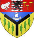 |
The arms of Yport are blazoned : Tierced per pall, 1: Azure, a ship argent, 2 &3: Or, 3 poplars vert, all around a pall sable; and a chief tierced per pale: 1: Gules, a frog contourny argent, 2: barry argent and gules, a lion sable, 3: Gules, 3 hammers Or.
|
Tourism[]
- Cliffs
- Pebble beach
- St. Martin's church: building started in 1838, it was finished only in 1876 after many modifications.
- Casino
- Yport is the place where Guy de Maupassant set his novel Une Vie
Festivals[]
- Torch-light parade on July 13.
- Festival of the sea and painting on August 15 (mass, blessing, holy procession). An exhibition of paintings, painters and sculptors in the streets and on the beach, auction sale at 5pm of the art created during the course of the day.
See also[]
- Communes of the Seine-Maritime department
References[]
- ^ "Populations légales 2018". INSEE. 28 December 2020.
External links[]
| Wikimedia Commons has media related to Yport. |
- Tourisme à Yport (in Japanese)
- Yport on the Insee website (in French)
| show Communes of the Seine-Maritime department |
|---|
| show Authority control |
|---|
- Communes of Seine-Maritime
- Seaside resorts in France