Şenpazar
Şenpazar | |
|---|---|
District | |
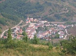 A panorama of Şenpazar | |
 Location of Şenpazar within Turkey. | |
 Şenpazar Location of Şenpazar | |
| Coordinates: 41°48′N 33°16′E / 41.800°N 33.267°E | |
| Country | |
| Region | Black Sea |
| Province | Kastamonu |
| Government | |
| • Mayor | Cem Çınar (AKP) |
| Area | |
| • District | 215.63 km2 (83.26 sq mi) |
| Elevation | 957 m (3,140 ft) |
| Population (2012)[2] | |
| • Urban | 1,623 |
| • District | 4,984 |
| • District density | 23/km2 (60/sq mi) |
| Time zone | UTC+2 (EET) |
| • Summer (DST) | UTC+3 (EEST) |
| Postal code | 37xxx |
| Area code(s) | 366 |
| Licence plate | 37 |
| Climate | Cfb |
| Website | www.senpazar.bel.tr |

Şenpazar, formerly Şarbana, is a town and district of the Kastamonu Province in the Black Sea region of Turkey. According to the 2015 census, population of the district is 5,176 of which 2,258 live in the town of Şenpazar.[3] The district covers an area of 216 km2 (83 sq mi),[4] and the town lies at an elevation of 957 m (3,140 ft).

Alancık village in Şenpazar
Notes[]
- ^ "Area of regions (including lakes), km²". Regional Statistics Database. Turkish Statistical Institute. 2002. Retrieved 2013-03-05.
- ^ "Population of province/district centers and towns/villages by districts - 2012". Address Based Population Registration System (ABPRS) Database. Turkish Statistical Institute. Retrieved 2013-02-27.
- ^ Turkish Statistical Institute. "Census 2000, Key statistics for urban areas of Turkey" (in Turkish). Archived from the original (XLS) on 2007-09-27. Retrieved 2008-11-11.
- ^ Statoids. "Statistical information on districts of Turkey". Archived from the original on 2010-07-24. Retrieved 2008-11-28.
References[]
- Falling Rain Genomics, Inc. "Geographical information on Şenpazar, Turkey". Archived from the original on 2012-10-26. Retrieved 2008-11-11.
External links[]
| Wikimedia Commons has media related to Şenpazar. |
Coordinates: 41°48′N 33°16′E / 41.800°N 33.267°E
This geographical article about a location in Kastamonu Province, Turkey is a stub. You can help Wikipedia by . |
Categories:
- Populated places in Kastamonu Province
- Şenpazar District
- Kastamonu Province geography stubs