Abana, Kastamonu
Abana | |
|---|---|
District | |
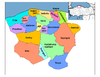
 Location of Abana within Turkey. | |
 Abana Location of Abana | |
| Coordinates: 41°59′N 34°01′E / 41.983°N 34.017°E | |
| Countryxalin | |
| Region | Black Sea |
| Province | Kastamonu |
| Government | |
| • Mayor | Yunus Akgül (AKP) |
| Area | |
| • District | 32.22 km2 (12.44 sq mi) |
| Population (2012)[2] | |
| • Urban | 2,889 |
| • District | 3,584 |
| • District density | 110/km2 (290/sq mi) |
| Time zone | UTC+2 (EET) |
| • Summer (DST) | UTC+3 (EEST) |
| Postal code | 37xxx |
| Area code(s) | 366 |
| Licence plate | 37 |
| Climate | Cfa |
| Website | www.abana-bld.gov.tr |

Abana is a town and district of the Kastamonu Province in the Black Sea region of Turkey. It is to the north-east of the province, on the shore of the Black Sea. According to the 2010 census, population of the district is 3583 of which 2,872 live in the town of Abana.[3] The district covers an area of 32 km2 (12 sq mi),[4] and the highest elevation is 300 m (984 ft).
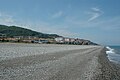
Abana's coastline is 11 km long, of which 7 km is a natural sand beach, making the district a popular summer resort for the region. On January 14, 2021, a temperature of 31.6 °C (88.9 °F) was recorded, the highest temperature in January in Turkey.[5]
History[]
Abana is the oldest town of Kastamonu,[citation needed] once a part of Paphlagonia, the town was ruled by the Danishmends, the Seljuk Turks, the Jandarid dynasty, and finally Ottomans. It was made a district of the Kastamonu province in 1945.
Transportion[]
Abana can be easily reached from Kastamonu via Devrakani and Bozkurt.
Neighbourhoods[]
- Akçam 41°56′13″N 34°05′20″E / 41.93694°N 34.08889°E
- Altıkulaç 41°57′39″N 34°05′09″E / 41.96083°N 34.08583°E
- Denizbükü 41°57′58″N 34°06′07″E / 41.96611°N 34.10194°E
- Elmaçukuru 41°56′27″N 34°04′09″E / 41.94083°N 34.06917°E
- Göynükler 41°57′36″N 34°04′08″E / 41.96000°N 34.06889°E
- Kadıyusuf 41°56′54″N 34°03′40″E / 41.94833°N 34.06111°E
- Yakabaşı 41°58′04″N 34°05′31″E / 41.96778°N 34.09194°E
- Yemeni 41°56′54″N 34°04′46″E / 41.94833°N 34.07944°E
- Yeşilyuva 41°58′32″N 34°04′17″E / 41.97556°N 34.07139°E
- Çampınar 41°58′15″N 34°03′32″E / 41.97083°N 34.05889°E
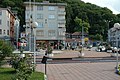
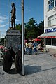
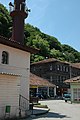
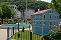
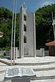
Gallery[]
Abana in 2005

Abana in 2005

Abana in 2005
Abana in 2005
Abana in 2005
Abana in 2005
Abana in 2005
Abana in 2005

Abana in 2005


References[]
- ^ "Area of regions (including lakes), km²". Regional Statistics Database. Turkish Statistical Institute. 2002. Retrieved 2013-03-05.
- ^ "Population of province/district centers and towns/villages by districts - 2012". Address Based Population Registration System (ABPRS) Database. Turkish Statistical Institute. Retrieved 2013-02-27.
- ^ Statistical Institute[permanent dead link]
- ^ Statoids. "Statistical information on districts of Turkey". Archived from the original on 2010-05-26. Retrieved 2008-11-22.
- ^ @extremetemps (13 January 2021). "Historic warmth in the Black Sea area:3 national records of highest January temperature fell: #Turkey with 31.6C at…" (Tweet) – via Twitter.
External links[]
- District governor's official website (in Turkish)
| show Abana, Kastamonu in Kastamonu Province of Turkey |
|---|
| show |
|---|
Coordinates: 41°58′33″N 34°00′41″E / 41.97583°N 34.01139°E
- Populated places in Kastamonu Province
- Fishing communities in Turkey
- Districts of Kastamonu Province