Brandeville
Brandeville | |
|---|---|
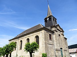 The church in Brandeville | |
 Coat of arms | |
show Location of Brandeville | |
 Brandeville | |
| Coordinates: 49°23′34″N 5°18′17″E / 49.3928°N 5.3047°ECoordinates: 49°23′34″N 5°18′17″E / 49.3928°N 5.3047°E | |
| Country | France |
| Region | Grand Est |
| Department | Meuse |
| Arrondissement | Verdun |
| Canton | Montmédy |
| Government | |
| • Mayor (2020–2026) | Luc Bourtembourg[1] |
| Area 1 | 12.14 km2 (4.69 sq mi) |
| Population (Jan. 2018)[2] | 182 |
| • Density | 15/km2 (39/sq mi) |
| Time zone | UTC+01:00 (CET) |
| • Summer (DST) | UTC+02:00 (CEST) |
| INSEE/Postal code | 55071 /55150 |
| Elevation | 193–377 m (633–1,237 ft) (avg. 235 m or 771 ft) |
| 1 French Land Register data, which excludes lakes, ponds, glaciers > 1 km2 (0.386 sq mi or 247 acres) and river estuaries. | |


Brandeville is a commune in the Meuse department in Grand Est in northeastern France.
Population[]
| Year | Pop. | ±% |
|---|---|---|
| 1962 | 237 | — |
| 1968 | 245 | +3.4% |
| 1975 | 204 | −16.7% |
| 1982 | 175 | −14.2% |
| 1990 | 136 | −22.3% |
| 1999 | 141 | +3.7% |
| 2009 | 169 | +19.9% |
See also[]
References[]
- ^ "Répertoire national des élus: les maires". data.gouv.fr, Plateforme ouverte des données publiques françaises (in French). 2 December 2020.
- ^ "Populations légales 2018". INSEE. 28 December 2020.
| Wikimedia Commons has media related to Brandeville. |
This Meuse geographical article is a stub. You can help Wikipedia by . |
Categories:
- Communes of Meuse (department)
- Meuse (department) geography stubs