Clinton, Louisiana
Clinton, Louisiana | |
|---|---|
Town | |
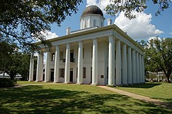 East Feliciana Courthouse in Clinton | |
 Location of Clinton in East Feliciana Parish, Louisiana. | |
 Location of Louisiana in the United States | |
| Coordinates: 30°51′47″N 91°00′57″W / 30.86306°N 91.01583°WCoordinates: 30°51′47″N 91°00′57″W / 30.86306°N 91.01583°W | |
| Country | |
| State | |
| Parish | East Feliciana |
| Government | |
| • Mayor | Lori Ann Bell (D) (elected 2012) |
| Area | |
| • Total | 2.76 sq mi (7.14 km2) |
| • Land | 2.74 sq mi (7.10 km2) |
| • Water | 0.02 sq mi (0.04 km2) |
| Elevation | 217 ft (66 m) |
| Population (2010) | |
| • Total | 1,653 |
| • Estimate (2019)[2] | 1,502 |
| • Density | 548.18/sq mi (211.66/km2) |
| Time zone | UTC-6 (CST) |
| • Summer (DST) | UTC-5 (CDT) |
| Zip Code | 70722 |
| Area code(s) | 225 |
| FIPS code | 22-15990 |
| Website | www |

Clinton is a town in, and the parish seat of, East Feliciana Parish, Louisiana, United States.[3] The town was named for New York Governor DeWitt Clinton.[4] The population was 1,653 at the 2010 census. It is part of the Baton Rouge Metropolitan Statistical Area.
History[]
In 1824, when Feliciana Parish was split into East and West, Clinton became the seat of East Feliciana Parish's government, replacing the town of Jackson in this capacity.
Several military engagements occurred during the American Civil War which involved Clinton. Union General Benjamin Grierson occupied Clinton on June 7, 1863, one month before the fall of Vicksburg, Mississippi. Grierson found the town deserted, as Confederates had withdrawn ten miles to the north. According to the historian John D. Winters in The Civil War in Louisiana (1863), the Union "burned a railroad depot, a warehouse containing several hundred hides, a small supply of corn, a machine shop, a locomotive, a crude woolen mill, a cartridge factory, a supply of ammunition, and several barrels of Louisiana rum."[5]
On September 5, 1864, Union General Albert L. Lee left Baton Rouge to make another raid on Clinton and destroyed a tannery at nearby Greensburg containing two thousand sides of leather.[6] On March 5, 1865, with only a few weeks remaining in the war, Union General Francis J. Herron moved from Baton Rouge toward Clinton and defeated a weak Confederate force. The Federal cavalry pushed twenty miles north of Clinton to discourage remaining Confederate activity in the area.[7]
In mid October 1948, an Air Force transport plane with 34 people aboard made a forced landing near the town, killing four.[8]
Geography[]
Clinton is located at 30°51′47″N 91°0′57″W / 30.86306°N 91.01583°W (30.863050, -91.015789).[9]
According to the United States Census Bureau, the town has a total area of 2.8 square miles (7.3 km2), of which 2.7 square miles (7.0 km2) is land and 0.04 square miles (0.10 km2) (0.72%) is water.
Demographics[]
| Historical population | |||
|---|---|---|---|
| Census | Pop. | %± | |
| 1870 | 930 | — | |
| 1880 | 112 | −88.0% | |
| 1890 | 974 | 769.6% | |
| 1900 | 960 | −1.4% | |
| 1910 | 918 | −4.4% | |
| 1920 | 701 | −23.6% | |
| 1930 | 702 | 0.1% | |
| 1940 | 998 | 42.2% | |
| 1950 | 1,383 | 38.6% | |
| 1960 | 1,568 | 13.4% | |
| 1970 | 1,884 | 20.2% | |
| 1980 | 1,919 | 1.9% | |
| 1990 | 1,904 | −0.8% | |
| 2000 | 1,998 | 4.9% | |
| 2010 | 1,653 | −17.3% | |
| 2019 (est.) | 1,502 | [2] | −9.1% |
| U.S. Decennial Census[10] | |||
As of the census[11] of 2000, there were 1,998 people, 670 households, and 481 families residing in the town. The population density was 729.0 people per square mile (281.5/km2). There were 771 housing units at an average density of 281.3 per square mile (108.6/km2). The racial makeup of the town was 40.74% White, 58.26% African American, 0.05% Native American, 0.15% Asian, 0.10% from other races, and 0.70% from two or more races. Hispanic or Latino of any race were 1.75% of the population.
There were 670 households, out of which 34.3% had children under the age of 18 living with them, 41.2% were married couples living together, 26.1% had a female householder with no husband present, and 28.1% were non-families. 26.6% of all households were made up of individuals, and 11.9% had someone living alone who was 65 years of age or older. The average household size was 2.71 and the average family size was 3.30.
In the town, the population was spread out, with 30.0% under the age of 18, 9.0% from 18 to 24, 27.5% from 25 to 44, 21.8% from 45 to 64, and 11.7% who were 65 years of age or older. The median age was 34 years. For every 100 females, there were 96.1 males. For every 100 females age 18 and over, there were 91.1 males.
The median income for a household in the town was $27,016, and the median income for a family was $29,444. Males had a median income of $32,500 versus $20,268 for females. The per capita income for the town was $13,353. About 25.3% of families and 33.6% of the population were below the poverty line, including 44.6% of those under age 18 and 23.7% of those age 65 or over.
Education[]
East Feliciana Parish School Board serves Clinton. Public schools within Clinton and serving Clinton include:
- Clinton Middle School
- Clinton Elementary School
This was changed in the Fall of 2010, when Clinton and Jackson High Schools merged to be housed at the old Jackson High/Middle School building in Jackson. Clinton Middle School was merged with Jackson Middle School and housed at the Clinton High School site.
Silliman Institute is the main private school in the area. Slaughter Community Charter School is the only charter school in the area.
Notable people[]
- John D. Travis, state representative for District 62 from 1984 to 2000; born in Clinton in 1940
- Shannon Dawson, college football coach
Media[]
- The 2005 film The Dukes of Hazzard was filmed in and around Clinton.[12]
- A 1972 made-for-TV movie, "Moon of the Wolf", was filmed in and around Clinton. Many scenes utilize the Courthouse square, the old hospital, the jail and homes in the area. This werewolf film starred David Janssen and Barbara Rush.
- The HBO hit series True Blood currently has a five-year contract with the town.[13]
- The 2016 film The Free State of Jones was filmed partly in Clinton.[14]
References[]
- ^ "2019 U.S. Gazetteer Files". United States Census Bureau. Retrieved July 25, 2020.
- ^ Jump up to: a b "Population and Housing Unit Estimates". United States Census Bureau. May 24, 2020. Retrieved May 27, 2020.
- ^ "Find a County". National Association of Counties. Archived from the original on 2011-05-31. Retrieved 2011-06-07.
- ^ "Profile for Clinton, Louisiana". ePodunk. Retrieved 2010-04-26.
- ^ John D. Winters, The Civil War in Louisiana, Baton Rouge: Louisiana State University Press, 1963, ISBN 0-8071-0834-0, p. 264
- ^ Wintrs, p. 397
- ^ Winters, p. 413
- ^ "4 Die as AF Plane Makes Crash Landing". Abilene Reporter News. 17 October 1948. Retrieved 21 November 2020.
- ^ "US Gazetteer files: 2010, 2000, and 1990". United States Census Bureau. 2011-02-12. Retrieved 2011-04-23.
- ^ "Census of Population and Housing". Census.gov. Retrieved June 4, 2015.
- ^ "U.S. Census website". United States Census Bureau. Retrieved 2008-01-31.
- ^ "The Dukes of Hazzard". Archived from the original on 2007-06-11. Retrieved 2007-05-20.
- ^ http://www.katc.com/Global/story.asp?S=10716470[permanent dead link]
- ^ WARREN, STEPHANIE (March 4, 2015). "Major motion picture to be filmed in Clinton". theadvocate.com. Retrieved March 7, 2015.
External links[]
| Wikimedia Commons has media related to Clinton, Louisiana. |
| show Municipalities and communities of East Feliciana Parish, Louisiana, United States |
|---|


| Authority control |
|---|
- Towns in East Feliciana Parish, Louisiana
- Towns in Louisiana
- Parish seats in Louisiana
- Towns in Baton Rouge metropolitan area