Dagonville
Dagonville | |
|---|---|
 Coat of arms | |
show Location of Dagonville | |
 Dagonville | |
| Coordinates: 48°47′33″N 5°23′50″E / 48.7925°N 5.3972°ECoordinates: 48°47′33″N 5°23′50″E / 48.7925°N 5.3972°E | |
| Country | France |
| Region | Grand Est |
| Department | Meuse |
| Arrondissement | Commercy |
| Canton | Vaucouleurs |
| Intercommunality | |
| Government | |
| • Mayor (2020–2026) | Dominique Wentz[1] |
| Area 1 | 13.01 km2 (5.02 sq mi) |
| Population (Jan. 2018)[2] | 84 |
| • Density | 6.5/km2 (17/sq mi) |
| Time zone | UTC+01:00 (CET) |
| • Summer (DST) | UTC+02:00 (CEST) |
| INSEE/Postal code | 55141 /55500 |
| Elevation | 284–387 m (932–1,270 ft) (avg. 300 m or 980 ft) |
| 1 French Land Register data, which excludes lakes, ponds, glaciers > 1 km2 (0.386 sq mi or 247 acres) and river estuaries. | |


Dagonville (French pronunciation: [daɡɔ̃vil]) is a commune in the Meuse department in Grand Est in north-eastern France.
Population[]
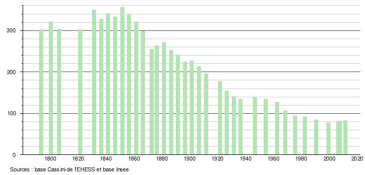
The population of Dagonville has slowly declined since the beginning of census-taking in 1793; whereas the commune once housed as many as 356 people, as of 2011 it housed only 82. A more detailed list exists below, according to the École des Hautes Études en Sciences Sociales, a major French graduate school specializing in social sciences.
Graphical representation of the population of Dagonville
| Year | Pop. | ±% |
|---|---|---|
| 2006 | 81 | — |
| 2007 | 81 | +0.0% |
| 2008 | 81 | +0.0% |
| 2009 | 82 | +1.2% |
| 2010 | 82 | +0.0% |
| 2011 | 82 | +0.0% |
| 2012 | 82 | +0.0% |
| 2013 | 82 | +0.0% |
| 2014 | 82 | +0.0% |
| 2015 | 83 | +1.2% |
| 2016 | 84 | +1.2% |
See also[]
References[]
- ^ "Répertoire national des élus: les maires". data.gouv.fr, Plateforme ouverte des données publiques françaises (in French). 2 December 2020.
- ^ "Populations légales 2018". INSEE. 28 December 2020.
| Wikimedia Commons has media related to Dagonville. |
This Meuse geographical article is a stub. You can help Wikipedia by . |
Categories:
- Communes of Meuse (department)
- Meuse (department) geography stubs