Gerberoy
From Wikipedia, the free encyclopedia
Commune in Hauts-de-France, France
Gerberoy | |
|---|---|
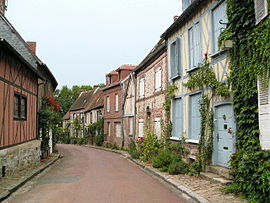 The main street in Gerberoy | |
 Coat of arms | |
 Gerberoy  Gerberoy | |
Coordinates:  49°32′06″N 1°51′02″E / 49.535°N 1.8506°E / 49.535; 1.8506Coordinates: 49°32′06″N 1°51′02″E / 49.535°N 1.8506°E / 49.535; 1.8506 49°32′06″N 1°51′02″E / 49.535°N 1.8506°E / 49.535; 1.8506Coordinates: 49°32′06″N 1°51′02″E / 49.535°N 1.8506°E / 49.535; 1.8506 | |
| Country | France |
| Region | Hauts-de-France |
| Department | Oise |
| Arrondissement | Beauvais |
| Canton | Grandvilliers |
| Intercommunality | Picardie Verte |
| Government | |
| • Mayor (2020–2026) | Pierre Chavonnet |
| Area 1 | 4.51 km2 (1.74 sq mi) |
| Population (Jan. 2018)[1] | 88 |
| • Density | 20/km2 (51/sq mi) |
| Time zone | UTC+01:00 (CET) |
| • Summer (DST) | UTC+02:00 (CEST) |
| INSEE/Postal code | 60271 /60380 |
| Elevation | 111–201 m (364–659 ft) (avg. 204 m or 669 ft) |
| 1 French Land Register data, which excludes lakes, ponds, glaciers > 1 km2 (0.386 sq mi or 247 acres) and river estuaries. | |

Gerberoy (French pronunciation: [ʒɛʁbəʁwa]) is a commune in the Oise department in northern France, in the old pays of Beauvaisis.
Contents
Toponymy[]
Gerboredum 11th Century. Germanic masculine name Gerbold and Old North French roy 'ford' (Celtic rito-, Old Welsh rit > Welsh rhyd)
A ford in the Thérain stream.
History[]
The old village with many half-timbered houses, and traces of the medieval castle, is listed in the plus beaux villages de France (Most beautiful French villages).
The siege and battle of Gerberoy was fought between William the Conqueror and his son Robert Curthose in the winter of 1078–79.
See also[]
References[]
- ^ "Populations légales 2018". INSEE. 28 December 2020.
| Wikimedia Commons has media related to Gerberoy. |
show
| |
|---|---|
| Prefecture |
|
| Subprefectures |
|
| Other |
|
show
Villages in the association Les Plus Beaux Villages de France | |
|---|---|
| Auvergne-Rhône-Alpes |
|
| Bourgogne-Franche-Comté |
|
| Brittany |
|
| Centre-Val de Loire |
|
| Corsica |
|
| Grand Est |
|
| Hauts-de-France |
|
| Île-de-France |
|
| Normandy |
|
| Nouvelle-Aquitaine |
|
| Occitanie |
|
| Pays de la Loire |
|
| Provence-Alpes-Côte d'Azur |
|
| Réunion | |
This Oise geographical article is a stub. You can help Wikipedia by . |
- v
- t
Retrieved from ""
Categories:
- Communes of Oise
- Plus Beaux Villages de France
- Oise geography stubs
Hidden categories:
- Articles with short description
- Short description is different from Wikidata
- Coordinates on Wikidata
- Pages using infobox settlement with image map1 but not image map
- Commons category link is on Wikidata
- Articles with GND identifiers
- Articles with VIAF identifiers
- Articles with BNF identifiers
- Articles with LCCN identifiers
- Articles with MusicBrainz area identifiers
- Articles with WorldCat-VIAF identifiers
- All stub articles
- Pages using the Kartographer extension