Gratentour
Gratentour | |
|---|---|
 A general view of Gratentour | |
 Coat of arms | |
show Location of Gratentour | |
 Gratentour | |
| Coordinates: 43°43′19″N 1°25′56″E / 43.7219°N 1.4322°ECoordinates: 43°43′19″N 1°25′56″E / 43.7219°N 1.4322°E | |
| Country | France |
| Region | Occitanie |
| Department | Haute-Garonne |
| Arrondissement | Toulouse |
| Canton | Castelginest |
| Intercommunality | Toulouse Métropole |
| Government | |
| • Mayor (2020–2026) | Patrick Delpech[1] |
| Area 1 | 4.09 km2 (1.58 sq mi) |
| Population (Jan. 2018)[2] | 4,272 |
| • Density | 1,000/km2 (2,700/sq mi) |
| Time zone | UTC+01:00 (CET) |
| • Summer (DST) | UTC+02:00 (CEST) |
| INSEE/Postal code | 31230 /31150 |
| Elevation | 123–194 m (404–636 ft) (avg. 170 m or 560 ft) |
| 1 French Land Register data, which excludes lakes, ponds, glaciers > 1 km2 (0.386 sq mi or 247 acres) and river estuaries. | |


Gratentour (French pronunciation: [ɡʁatɛ̃tuʁ]; Occitan: Gratentorn) is a commune in the Haute-Garonne department in southwestern France.
Population[]
| Year | Pop. | ±% |
|---|---|---|
| 1962 | 388 | — |
| 1968 | 646 | +66.5% |
| 1975 | 924 | +43.0% |
| 1982 | 1,574 | +70.3% |
| 1990 | 2,518 | +60.0% |
| 1999 | 3,035 | +20.5% |
| 2008 | 3,626 | +19.5% |
Monument[]

Town hall

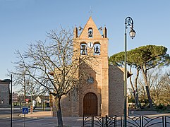
Sainte Quitterie church
Bell gabel of Sainte Quitterie church


See also[]
References[]
- ^ "Répertoire national des élus: les maires". data.gouv.fr, Plateforme ouverte des données publiques françaises (in French). 2 December 2020.
- ^ "Populations légales 2018". INSEE. 28 December 2020.
| Wikimedia Commons has media related to Gratentour. |
This Haute-Garonne geographical article is a stub. You can help Wikipedia by . |
Categories:
- Communes of Haute-Garonne
- Haute-Garonne geography stubs