Latoue
Latoue | |
|---|---|
 Chateau | |
show Location of Latoue | |
 Latoue | |
| Coordinates: 43°10′12″N 0°47′11″E / 43.17°N 0.7864°ECoordinates: 43°10′12″N 0°47′11″E / 43.17°N 0.7864°E | |
| Country | France |
| Region | Occitanie |
| Department | Haute-Garonne |
| Arrondissement | Saint-Gaudens |
| Canton | Cazères |
| Intercommunality | CC Cœur et Coteaux du Comminges |
| Government | |
| • Mayor (2020–2026) | Pierre Bosc |
| Area 1 | 17.62 km2 (6.80 sq mi) |
| Population (Jan. 2018)[1] | 320 |
| • Density | 18/km2 (47/sq mi) |
| Time zone | UTC+01:00 (CET) |
| • Summer (DST) | UTC+02:00 (CEST) |
| INSEE/Postal code | 31278 /31800 |
| Elevation | 333–488 m (1,093–1,601 ft) (avg. 350 m or 1,150 ft) |
| 1 French Land Register data, which excludes lakes, ponds, glaciers > 1 km2 (0.386 sq mi or 247 acres) and river estuaries. | |


Latoue is a commune in the Haute-Garonne department in southwestern France.
Population[]
| Year | Pop. | ±% |
|---|---|---|
| 1962 | 312 | — |
| 1968 | 379 | +21.5% |
| 1975 | 327 | −13.7% |
| 1982 | 323 | −1.2% |
| 1990 | 294 | −9.0% |
| 1999 | 284 | −3.4% |
| 2008 | 308 | +8.5% |
Sights[]
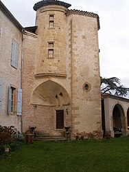
The Château de Latoue is a castle first built in the 12th century, with major additions and alterations in the 13th, 16th and 18th centuries. Privately owned, it has been listed since 1979 as a historic site by the French Ministry of Culture.[2]
See also[]
References[]
- ^ "Populations légales 2018". INSEE. 28 December 2020.
- ^ Base Mérimée: Château, Ministère français de la Culture. (in French)
| Wikimedia Commons has media related to Latoue. |
This Haute-Garonne geographical article is a stub. You can help Wikipedia by . |
Categories:
- Communes of Haute-Garonne
- Haute-Garonne geography stubs